Given a recent business trip to Australia and New Zealand in the second half of October 2014, MoMI took advantage of an opportunity to document a small portion of these two fascinating countries. Presented below is a photographic narrative of the sights and scenes encountered on this whirlwind visit.
17-23 October 2014: Wellington, New Zealand
 |
| An Air New Zealand boarding pass for an Auckland-Wellington flight (NZ 477) on 17 October 2014. |
Upon arrival in New Zealand's capital city late on Friday, 17 October, the #91 Airport Flyer bus provided an easy and affordable ($9) way to get to the Bolton Hotel, located next to the parliamentary district.
 |
| The bedroom of room 1308 at the Bolton Hotel. |
 |
| A spacious bathroom in Room 1308. |
 |
| The Bolton Hotel provides guests with an assortment of upmarket toiletries. |
 |
| A comfortable sitting area includes a dining set, at right. |
 |
| A well-appointed full kitchen with stainless steel countertop, a full complement of dishes and utensils, and even a combo laundry washer/dryer. |
 |
| The front and reverse sides of a Dilmah English Breakfast tea sachet provided as part of the tea service in Room 1308 of the Bolton Hotel, Wellington. |
 |
| The door hanger menu for the Bolton Hotel's room service. |
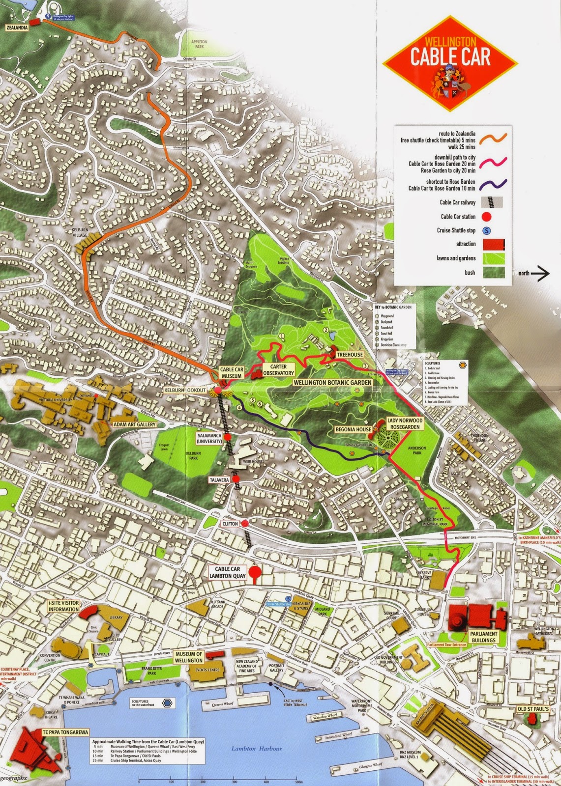
Above and below: A free map available at the Wellington Visitors' Centre, depicting the Wellington region and, below, the city centre, including attractions and notable sights.
 |
| The historic Turnbull House on Bowen Street, built in 1918 for Alexander Turnbull. When Turnbull died in 1919, he left this house and his large collection of maps, pictures, documents, and over 55,000 books to the Crown. The Alexander Turnbull Library opened in 1920 and closed in 1973, when the collection was moved to the National Library of New Zealand. Turnbull House now serves as a meeting and function venue. |
 |
| The Beehive, the executive wing of the New Zealand Parliament Buildings. Built in stages between 1969 and 1979, the Beehive was opened by Queen Elizabeth II in 1977. The ten-story building houses the Cabinet room and Prime Minister's office on the ninth floor, while other Cabinet ministers' offices are located on other floors. |
 |
| Parliament House (right) and the Beehive (left). Parliament House, the main building in the parliamentary complex, houses the Debating Chamber, Speaker's office, Visitors' Centre, and committee rooms. Construction of Parliament House began in 1914 and was not finally completed until 1922, although Members of Parliament had moved into the unfinished building in 1918. Queen Elizabeth II opened Parliament House in 1995 after an extensive renovation and strengthening. |
 |
| The Parliamentary Library, built in the Gothic Revival style in 1899. It is the oldest of the Parliament Buildings, having survived a devastating 1907 fire that destroyed the original wooden Parliament House. A fireproof iron door separates the library from the main entrance and was instrumental in saving the library collection in 1907. |
 |
| The National Library of New Zealand, at the corner of Aitken and Molesworth Streets. The building opened in August 1987. |
 |
| St. Paul's Cathedral, the cathedral church of the Anglican Archdiocese of Wellington. Given lessons learned from the 1931 earthquake in Napier, New Zealand, St. Paul's Cathedral was constructed out of reinforced concrete, construction commencing in 1955. Despite not being officially completed until 1998, it began functioning as a cathedral in 1964. |
 |
| New Zealand Rugby House, home of the New Zealand Rugby Union (NZRU). The NZRU is responsible for administering the game of rugby union at the national level and fostering, developing, administering, promoting, and representing the game of rugby in New Zealand. |
 |
| Old St. Paul's, the cathedral church of the Anglican Diocese of Wellington between 1866 and 1964. Designed in the Gothic Revival style, but constructed out of native timber, Old St. Paul's was saved from demolition after the opening of the new St. Paul's Cathedral in 1964 and purchased by the Government of New Zealand. Restored by the Ministry of Works, Old St. Paul's is now a publicly-accessible historic site. |
 |
| Despite these prominent signs posted in various parts of the city, empty beer bottles and cans were evident in several locations, including parks. |
 |
| Wellington Railway Station, the terminus of the North Island Main Trunk, Wairarapa Line, and Johnsonville Line railways. The station was built between 1934 and 1937 on 68 hectares of land reclaimed from the sea, and opened on 19 June 1937 by the Governor General of New Zealand, Viscount Galway. |
 |
| Although Wellington Station is New Zealand's busiest railway station, this is not apparent on a quiet Saturday afternoon. |
 |
| Entrances to some of the platforms served by 390 trains every day, carrying an estimated 29,000 people. |
 |
| A view down Platform 8. |
 |
| A Steam Incorporated historic train at Platform 9. |
 |
| A historic steam train sits next to a modern commuter train at Wellington Railway Station. The restored historic ex-New Zealand Government Railways train on the right is preparing to depart on the Heartland Rail Tour 2014, a special excursion for rail fans. |
 |
| Government Buildings Historic Reserve (also called the 'Old Government Buildings'), built in 1876 and now home to Victoria University's Law School. |
 |
| Built out of wood due to the high cost of concrete in the 1870s, the Old Government Buildings were designed in the Italianate, Neo-Renaissance style and made to look like stone. The building was constructed largely with native New Zealand kauri timber. Harvesting of kauri trees is now prohibited due to the near loss of all of New Zealand's once-plentiful kauri forests. The trees seen flanking each side of the building's entrance are kauri. The kauri tree is known for growing tall and straight, with no knots and an easily-worked honey-coloured wood; some kauri trees have survived 2,000 years, growing up to 60 metres in height. |
 |
| The Supreme Court of New Zealand's new home, opened on 18 January 2010 by Prince William. The building cost $80.7 million. |
 |
| A view up Lambton Quay, the main street through Wellington's Central Business District. Once the high-water mark of Wellington harbour and the site of the original settlement in 1840, the 1855 Wairarapa earthquake caused land to rise out of the harbour, leaving Lambton Quay 250 metres from the current shoreline. Originally named Beach Street, Lambton Quay was renamed after John Lambton, 1st Earl of Durham, first chairman of the directors of the New Zealand Company, which colonised New Zealand. |
 |
| The Public Trust building, built in 1908 at the corner of Lambton Quay and Stout Street. The first building in Wellington constructed using a steel skeleton, the granite-faced building was designed to resist fires and earthquakes. The Public Trust housed important papers, including wills, estates, and probates. |
 |
| The Kirkcaldie & Stains department store at the corner of Lambton Quay and Brandon Street. This iconic department store opened at this location in 1868. |
 |
| The Harbour City Centre Shopping Centre. |
 |
| The Mutual Life & Citizens Assurance Company Ltd. Building, also known as Richard Ellis House or the MLC building, located at the intersection of Lambton Quay, Hunter Street, and Featherston Street. Constructed in 1940 for the Australian-based Mutual Life & Citizens Assurance Company, the building served as the headquarters for the New Zealand branch of the company until 1985. The clock was installed in 1953. |
 |
| Looking south on Lambton Quay, Wellington's main commercial avenue. |
 |
The Old Bank Arcade (1901), a shopping centre housed in the former headquarters of The Bank of New Zealand. Left empty after the bank moved out, the building was restored between 1997 and 1999. During the restoration, the remains of a three-masted sailing ship deposited on the site during the major 1855 earthquake that rocked Wellington were unearthed; the bow section can now be seen under the floor in the old bank vaults.
|
 |
| Civic Square, completed between 1987 and 1992. The open public space houses the City Gallery, Wellington Central Library, Town Hall, City Council buildings, and a visitors information centre. The large silver sphere is a sculpture suspended in mid-air on cables anchored on the surrounding buildings. |
 |
| City Gallery Wellington, housed in the former Wellington Central Library. The gallery lacks a permanent collection and mounts rotating exhibitions. The building was built in 1940, and the City Gallery Wellington moved in in 1993. |
 |
| Looking up Jervois Quay, a high-capacity boulevard running through downtown Wellington, next to the harbour. |
 |
| Frank Kitts Park, named after a former city mayor and situated on Wellington harbour, with office towers and residential highrises located in the background. |
 |
| A fountain on the edge of Frank Kitts Park, overlooking the basin used by rowing clubs. |
 |
| The Michael Fowler Centre, the city's pre-eminent concert hall and convention centre, built between 1980 and 1983 and named after a former Wellington mayor. The main auditorium seats up to 2,210 people and is home to the New Zealand Symphony Orchestra. |
 |
| Looking south on Victoria Street at Wakefield Street. |
 |
| The Wellington Harbour Board Wharf Office Building, also known as Shed 7, located at Queens Wharf, just off Jervois Quay. The building houses the New Zealand Academy of Fine Arts. |
 |
| Queens Wharf, an entertainment district on the Wellington waterfront. Comprising a mix of restored and new buildings, Queens Wharf is home to various bars and restaurants, the New Zealand Academy of Fine Arts, the Museum of Wellington City & Sea, and the TSB Bank Arena. |
 |
| A quiet morning at Bin 44 Restaurant and Bar, located on Queens Wharf. |
 |
| A historic port crane left as an iconic reminder of Wellington harbour's industrial past. |
 |
| The Bluebridge roll-on/roll-off ferry Santa Regina. Built in France in 1985 for the Marseille-Corsica overnight run, the 449 foot, 14,588 gross ton flagship of Bluebridge Line now crosses the Cook Strait between New Zealand's North and South Islands. |
 |
| A tourist sightseeing helicopter swoops past after taking off from its helipad on an old jetty in Wellington harbour. |
 |
| Wellington's self-described premier seafood restaurant, Shed 5 occupies one of Wellington harbour's oldest buildings. The former woolshed now houses both the Shed 5 restaurant and the Crab Shack seafood restaurant. Shed 5 has its own on-site fishmonger. |
 |
| The Museum of Wellington City & Sea, housed in the former Wellington Harbour Board Head Office and Bond Store. Built to replace an older wooden building from the 1860s, this building was designed in the French Second Empire style and completed in 1892. It now houses three floors of exhibits and artefacts related to the history of Wellington. |
 |
| Visitors enter the museum galleries through a recreation of what the Bond Store would have looked like in its heyday, piled high with barrels, bales, and sacks of goods offloaded from freighters. |
 |
A recreated bookkeeper's desk.
|
 |
| As a bonded cargo warehouse, the Bond House stored cargo requiring the payment of customs duty before being released to importers. |
 |
| The ground floor gallery, Telling Tales, recounts one story of Wellington's history for each year from 1900 to the present. |
 |
| Telling Tales features a diverse range of artefacts on display, from statues, clothing, and models to personal affects, furniture, and documents. |
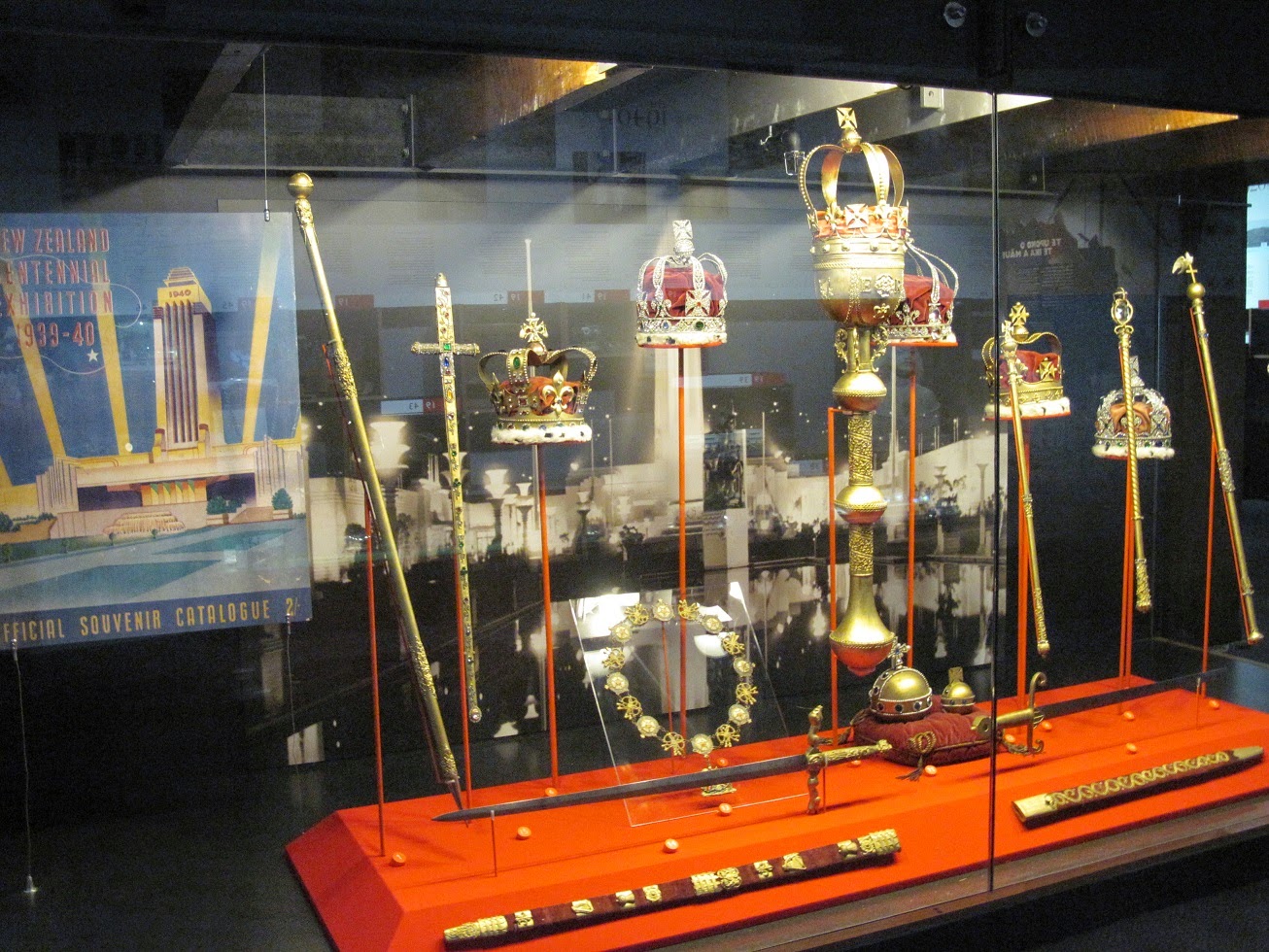 |
| A replica set of the British Crown jewels, created for the New Zealand Centennial Exhibition in 1939. |
 |
| The boardroom of the Wellington Harbour Board, with a giant framed map of Wellington harbour mounted on the wall behind the Chairman's seat. |
 |
| A large model of the steel, four-masted barque Pamir. The ship was built in Germany in 1905 and used to haul nitrates from Chile to Europe and, later, grain from South Australia to Europe via Cape Horn. Seized by the New Zealand government as a war prize whilst in Wellington harbour in August 1941, the ship was used by New Zealand's Union Steamship Line to carry cargo to San Francisco, Vancouver, and Sydney, as well as make a circumnavigation of the globe to London and Antwerp. Returned to her original German owners in 1948, Pamir served as a cargo-carrying auxiliary training ship before foundering in the North Atlantic during Hurricane Carrie on 21 September 1957. Eighty of the eighty-six crewmen aboard died. The brass binnacle cover on the left is from the steam-powered grab dredger Kerimoana (1938-1981). |
 |
| A model of the 8,303 gross ton passenger and vehicle ferry TEV Maori. Built at Newcastle-on-Tyne, UK in 1953, Maori could carry 966 passengers and 70-80 cars, as built. Modified to a roll-on/roll-off configuration in 1965, Maori's new capacity was 790 passengers and 100 cars. Withdrawn from service in 1972, Maori was sold for scrapping and broken up at Kaohsiung, Taiwan in 1974. Over its service life, Maori steamed 1,082,134 nautical miles, made approximately 6,000 crossings of the Cook Strait, and carried 1,239,772 passengers. |
 |
| A recreated ship's cabin installed in the museum. |
 |
| Models and artefacts from various ferries serving the inter-island route from Wellington to New Zealand's South Island. |
 |
| A diorama depicting the sinking of the Union Steamship Company roll-on/roll-off passenger and vehicle ferry Wahine on 10 April 1968. The Wahine foundered on Barrett Reef at the entrance to Wellington harbour during a severe storm and sank, killing 53 of the 610 passengers and 123 crew aboard. The disaster occurred a short distance from the shores of Wellington's eastern suburbs and was extensively covered by the media at the time. |
 |
| Artefacts and memorabilia from the Wahine. |
 |
| The Museum of Wellington City & Sea covers three floors of the former Bond House. The building's original wooden pillars and floors and iron fasteners are well preserved. |
 |
| The top floor of the museum features galleries devoted to the history of Wellington, covering the city's early political, economic, educational, and social history. |
 |
| A display on haberdashery profiles Wellington's Hill and Sons Hat and Cap Manufacturers, established in 1875. Sold by the Hill family in 1955, the company is still producing hats today. |
 |
| A Maori sculpture incorporating intricate wood carving and woven fabric. |
 |
| A sunny day on the Wellington waterfront. The tall, yellow object is the mast of the ferry Wahine, which sank outside Wellington harbour on 10 April 1968. The mast was salvaged and erected in Frank Kitts Park on the waterfront as a memorial to the 53 people who died in the Wahine disaster. |
 |
| A Wellington cable car enters the Lambton Quay station, located on Cable Car Lane. |
 |
| Front and reverse sides of a return ticket on the Wellington Cable Car, purchased at the Lambton Quay terminus on 18 October 2014. |
Below: A useful guide briefly outlines the story and engineering details of the Wellington Cable Car.
 |
| An iconic symbol of Wellington, the funicular railway traverses 2,008 feet of track, rising 394 feet from the Central Business District at Lambton Quay to the suburb of Kelburn Hills, overlooking the city. The track's grade is 17.86%. |
 |
| The interior of one of the two Wellington cable cars. |
 |
| Between the Lambton Quay and Kelburn terminals, the cable car stops at three stations (Clifton, Talavera, and Salamanca) named after nearby streets. |
 |
| Passengers board for the return trip to the city. Around 1 million passengers use the cable car each year, including local residents commuting from Kelburn to the city, tourists, and students attending Victoria University, whose campus is located near the Salamanca station. |
 |
| The Wellington Cable Car offers spectacular views of the city and Wellington harbour in the distance. Opened in February 1902, the cable car operated with few changes until the current Swiss designed cars were purchased in 1978. |
 |
| The Kelburn terminal, at the entrance to the Wellington Botanic Garden. |
 |
| Native New Zealand cabbage trees frame a stunning view of Wellington harbour from the lookout located next to the Kelburn cable car station. |
 |
| Looking southeast over Wellington from Kelburn. |
 |
| Looking northeast at the expanse of Wellington harbour. |
 |
| The Wellington Cable Car Museum, a free museum devoted to telling the history of the city's funicular railway. The museum is located in the original Winding House, built in 1902, to house the steam engine and winding gear, as well as serve as a maintenance depot for the cable cars. |
 |
| The 100+ year old Grip Car 1, conserved as it looked in the mid-1970s, and placed on display in the Wellington Cable Car Museum. |
 |
| Informative panels lining the walls around Grip Car 1 tell the history of the Wellington Cable Car. These panels describe the replacement of the original, 76-year old grip cars with the present Swiss-designed cars on 22 September 1978. |
 |
| The restored Grip Car 3, now on display in the Wellington Cable Car Museum. Brought into service in 1904, Grip Car 3 was retired in January 1975 and restored in the mid-2000s. |
 |
| The original winding gear for the Wellington Cable Car is now an exhibit in the museum. |
 |
| The entrance to the Wellington Botanic Garden's 25 hectares of protected native forest, specialised plant collections, and floral displays. |
 |
| The Dominion Observatory Building, built in the Botanic Garden in 1907 to track New Zealand Standard Time. Seismic measurements were first recorded here in 1916 and automated equipment continues to monitor seismological activity in the Wellington area today. The observatory was built atop the magazine of the 1896 Garden Battery gun position. |
 |
| A Krupp gun manufactured in 1907 and captured near La Vacquerie, France by the New Zealand Division on 29 September 1918 during an attack on the Germans' Hindenburg Line. Sent back to New Zealand as a war trophy, the gun was donated to the City of Wellington in 1920 in recognition of the soldiers of the Wellington District. This gun is believed to be the only surviving example of its type of 190 manufactured by Friedrich Krupp AG of Essen, Germany. |
 |
| The Botanic Garden houses a large variety of trees and plants from various parts of the world. Here, a sign announces the start of the Australian Garden. |
 |
| Giant tree ferns and other sub-tropical plants tower over a ravine in the Wellington Botanic Garden. |
 |
| A coral tree (Erythrina crista-galli), native to Uruguay, Brazil, Paraguay, and Argentina. |
 |
| Walking paths and hiking trails criss-cross the Wellington Botanic Garden. |
 |
| The succulent garden showcases a broad range of these thick, fleshy species. |
 |
| A monkey puzzle tree (Araucaria araucana), native to central and southern Chile and western Argentina. |
 |
| Looking down on the duck pond from the deck of the Treehouse, a visitor centre located in the Wellington Botanic Garden. |
 |
| A vivid, pink flower on a tea tree (camellia sinensis). |
 |
| A bed of Gerrit Vander Valk tulips. |
 |
| A small waterfall and creek cuts through the leafy sub-tropical plants on display in the Wellington Botanic Garden. |
 |
| A gazebo overlooks the duck pond in the Wellington Botanic Garden. |
 |
| Various species of native pines grow tall on either side of the Pine Hill Path in the Wellington Botanic Garden. |
 |
| The Herb Garden, displaying a variety of culinary, fragrant, and medicinal herbs. |
 |
| The Lady Norwood Rose Garden, as seen from the ridge above, en route from the Herb Garden. |
 |
| Lemon trees growing outside the Begonia House in the Lady Norwood Rose Garden. |
 |
| A rare kauri tree. Forests of these conifers once blanketed New Zealand but most were chopped down for timber and harvesting of the species has been prohibited since 1985. |
 |
| Dappled sunlight penetrates the Serpentine Way path leading away from the Lady Norwood Rose Garden. |
 |
| Looking up Cuba Street, well-known for its bohemian character and eclectic boutiques, galleries, bars, and eateries. Named after the Cuba, an early settler ship to New Zealand, the street's middle section is closed to traffic. |
 |
| Cuba Street's iconic bucket fountain sculpture, installed in 1969. Water fills the tiered buckets until they tip and spill their contents into buckets underneath and the fountain pool. |
 |
| Another view of Cuba Street, one of Wellington's busiest pedestrians areas. |
 |
| The main entrance to the Museum of New Zealand Te Papa Tongarewa ('the place of treasures of this land'), referred to locally simply as Te Papa. This national museum and gallery opened on 14 February 1998 and recognises the bicultural makeup of New Zealand (English and Maori). |
 |
| The main atrium of Te Papa. The museum spans six floors, and includes numerous galleries and exhibitions devoted to New Zealand geology, flora and fauna, history, culture, and art, as well as gift shops and restaurants. |
 |
| The Mountains to Sea gallery on Level 2 features a diverse collection of 2,500 animal, fish, bird, insect, and plant species native to New Zealand, as well as the skeletons of various whales and sharks found in local waters. A focal point of the collection is the world's largest specimen of a colossal squid, caught by New Zealand fishermen in Antarctica's Ross Sea. The squid was donated to Te Papa in March 2007 and is 14 feet long and 1,091 pounds. |
 |
| The skeleton of a 21-metre long pygmy blue whale hangs from the ceiling in the Mountains to Sea exhibition. |
 |
| The aquatic section of the exhibit features examples of the whales, sharks, and porpoises that call New Zealand waters home. |
 |
| One of ten cast iron cannons, dating from around 1750, that were carried aboard Lieutenant James Cook's ship, His Majesty's Barque Endeavour. This cannon was thrown overboard on 11 June 1770 to lighten Endeavour after it became stuck on the Great Barrier Reef during Cook's 1768-1771 voyage to chart the east coast of Australia. The cannon was retrieved in 1970, cleaned and restored by the Government of Australia, and presented to New Zealand on the 200-year anniversary of Cook's visit to New Zealand. |
 |
| The Te Papa Museum's Signs of a Nation permanent exhibit, telling the story of the 1840 Treaty of Waitangi. A giant glass replica of the treaty (left), and panels containing the English and Maori text of the original document, are complemented by the vertical posts, from which emanate recorded voices of New Zealanders providing perspectives and opinions on the Treaty of Waitangi from 1840 to the present day. |
 |
The central atrium of the Te Papa Museum.
|
 |
| Awesome Forces, an exhibition on Level 2, tells the story of New Zealand's geologic and seismic history, as well as the unique prehistoric species that developed on New Zealand following its separation from the Gondwanaland supercontinent 85 million years ago. The exhibition also has an audio-visual presentation on the Maori creation tale and displays on the work of New Zealand's Earthquake Commission. |
 |
| A giant moa bird is attacked by a prehistoric eagle species in this display within the Awesome Forces exhibition. The moa were hunted to extinction by Maori settlers within 50 years of their arrival on New Zealand. |
 |
| A wooden walkway snakes through Bush City, a recreated native New Zealand landscape, featuring rainforest and volcanic zones. |
 |
| A swing-bridge crosses a gully in Bush City. |
 |
| A cave complex showcases stalactites and geological features common in New Zealand. |
 |
| A waterfall cascades down a rock wall, creating a humid environment for local plants. |
 |
| A view of the layout of several of Te Papa's exhibitions on Level 4. |
 |
| One of the displays inside Slice of Heaven: 20th Century Aotearoa, a permanent exhibition that tells the story of New Zealand from 1900. Here, artefacts associated with New Zealanders' fervent emotional attachment to the British Empire are displayed, including items celebrating the Diamond Jubilee of Queen Victoria and the commissioning of the battlecruiser HMS New Zealand in 1912. |
 |
| A display on New Zealand's agricultural heritage, including its famous dairy industry. The glass case contains a stuffed and mounted Jersey cow designed for New Zealand dairy industry demonstrations at agricultural fairs in the United Kingdom. Liquid could be poured through a zippered access point in the cow's neck, with demonstrators 'milking' the cow's udder to show urban audiences how milk was produced. |
 |
| A DeHavilland DH82a Tiger Moth biplane (registration ZK-AJO) used for crop dusting. This aircraft, like many similar planes declared surplus after the Second World War, were modified and used to spread agricultural chemicals. Flown from the back seat, the front seat and instrument panel were stripped out and replaced with a hopper and release mechanism for the chemicals. |
 |
| The Tangata o le Moana exhibition dedicated to the history and culture of Pacific Islanders. |
 |
| A display on Pacific Islanders' weapons and tools. |
 |
| The Mana Whenua ('power of the land') gallery commemorates the history and culture of the Maori people through artefacts, documents, and oral histories. |
 |
| A replica Maori waka (voyaging canoe) on display in Te Papa's Mana Whenua gallery. |
 |
| New Zealand's national art collection is housed in 11 galleries on the museum's Level 5. |
 |
| The Amora Hotel, located near Wellington harbour on Wakefield Street. |

Above and below: Amora Hotel brochure, outlining amenities and services offered.
 |
| Keycard envelope, Room 512, Amora Hotel, Wellington. |
 |
| Front and reverse sides of the Room 512 keycard. |
 |
| Waxed paper coaster, Amora Hotel, Wellington. |
 |
| Room 512 at the Amora Hotel, recently renovated. |
 |
| The comfortable room features a large wardrobe, desk, flatscreen television and tea service. |
 |
| Provided by the Amora Hotel, these large bath and smaller hand soaps are made in Malaysia. |
 |
| The view from Room 512 of the Amora Hotel. |
 |
| Wellington's Central Fire Station in Oriental Bay, built in the Art Deco style in 1939. |
 |
| The Mt. Vic Chippery, located at 5 Marjoribanks Street in Wellington. This busy little restaurant allows patrons to choose their type of fish, batter, sauce, and cut of chip (e.g. wedges, shoestring, crinkle cut, etc.). |
 |
| Brisk business at the Mt. Vic Chippery as some patrons line up to order and others wait for their orders to be prepared and served up in a unique cardboard box. |
 |
| Pleasure craft moored at a marina in Wellington harbour. |
 |
| The Interislander vehicle and rail ferry Aratere manoeuvres in Wellington harbour. The 602 foot-long, 12,596 ton vessel carries 670 passengers, 230 cars or 30 trucks, and 32 rail cars through the Cook Strait from Wellington to the South Island terminus at Picton. |
 |
| The pedestrian route along Oriental Parade offers stunning views of Wellington harbour. |
 |
| Oriental Parade features the closest beaches to Wellington's Central Business District, and is a popular neighbourhood due to its proximity to downtown and its many leisure and recreational amenities. |
 |
| Houses perched on the cliffs of Mount Victoria provide stunning views of the inner harbour and city. |
 |
| One of the many footpaths that wind around Mount Victoria in Wellington's eastern suburbs, near Oriental Bay. |
 |
| Central Wellington, seen from about halfway up the slope of Mount Victoria. |
 |
| A cyclist rides past a pine forest, along one of the many bike paths that snake through the parkland comprising Mount Victoria. |
 |
| A cannon hauled up to the top of Mount Victoria in the late 1800s to fire the noonday gun. |
 |
| People climb the steps to reach the Mount Victoria Lookout. |
 |
| A spectacular view of Wellington from the top of Mount Victoria. |
 |
| Looking south from the Mount Victoria Lookout. The water in the distance is the Cook Strait separating New Zealand's North and South Islands. |
 |
| A view of Wellington harbour from the Mount Victoria Lookout. |
 |
| A closeup of Wellington, taken from the top of Mount Victoria. |
 |
| A view of Westpac Stadium and Wellington's container port, as seen from the top of Mount Victoria. The stadium opened on 3 January 2000 and is home to the Wellington Lions ITM Cup rugby team and the Super Rugby Hurricanes, as well as hosting frequent matches by the New Zealand national rugby union team (the 'All Blacks'). Due to the shape and metallic walls, Westpac Stadium is often called 'The Cake Tin' by locals. |
 |
| An aerial view of the Te Papa Museum. |
 |
| An Air New Zealand plane lands at Wellington Airport, as seen from the top of Mount Victoria. |
 |
| The New Zealand National Memorial to Rear Admiral Richard E. Byrd, who used New Zealand as his base for expeditions to Antarctica for over 27 years. The memorial, unveiled on 11 March 1962, five years after Byrd's death, is designed to resemble a polar tent. The front of the memorial is clad in rocks from Antarctica and a bronze bust of Byrd. |
 |
| Sunset at the Mount Victoria Lookout. |
 |
| Dusk falls over Wellington harbour and the homes of Oriental Bay. |
 |
Looking down the steep Marjoribanks Street.
|
 |
| The intersection of Cambridge Terrace and Courtenay Place. Courtenay Place is a thriving entertainment district, with a number of restored, historic theatres, restaurants, bars, and stores. |
 |
| A paper napkin obtained at Nando's (global piri-piri chicken chain restaurant) on Courtenay Place, Wellington. |
 |
| Art Deco buildings along the Wellington waterfront. The foreground building is the former base for the Wellington Free Ambulance, a charitable organisation providing free ambulance services in the Wellington District. The Free Ambulance moved out of this building in the early 1990s, and it was converted to offices and a restaurant/bar. |
 |
| The Te Raukura Wharewaka Function Centre, which contains the 100-seat Karaka Cafe. |
 |
| While Wellington has worked to preserve many historic buildings on its waterfront, a number of new buildings have been added, featuring a distinctive New Zealand architectural style. |
 |
| A battered tug tied up alongside a warehouse in Wellington harbour. |
 |
| Ex-HMNZS Wakakura, a Moa-class inshore patrol vessel built in 1985 for the Naval Volunteer Reserve and decommissioned 11 December 2007. The vessel has been tied up at Queen's Wharf in Wellington since being taken out of service. |
 |
| A line of tugboats moored near the Bluebridge Cook Strait Ferry Terminal at dusk. |
 |
| The Art Deco-styled former Hotel Waterloo, opened on 16 October 1937. Closed in 1987 and restored in 1991, the hotel has been extensively restored since 1997 by its current owners and, rebranded as Waterloo Hotel and Backpapers in 2014, now has a capacity for 270 guests. |
23-24 October 2014: Canberra, Australia
Flying out of Wellington at 6:40am on 23 October aboard Qantas flight QF 162, we arrived at the Domestic Terminal of Sydney's Kingsford Smith International Airport for the connecting flight to Canberra (QF 1419).
 |
| Qantas JetConnect boarding pass for flight QF 162, from Wellington, New Zealand to Sydney, Australia. |
 |
| Qantas-branded sugar packet provided with a cup of hot tea with milk. |
 |
| Qantas 737-800, registration VH-XZD, sits at a gate at the Domestic Terminal of Sydney's Kingsford Smith International Airport, 23 October. |
 |
| A QantasLink Q400 turboprop prepares to take on fuel at the Domestic Terminal of Kingsford Smith International Airport. |
 |
The concourse at the Domestic Terminal.
|
 |
| Another view of the Domestic Terminal retail concourse. |
 |
| Passengers can enjoy a number of food and beverage outlets, or peruse a wide selection of gifts and other merchandise at the many shops in the Domestic Terminal. |
 |
| The spacious atrium inside the East Hotel in Canberra, featuring modernist architecture, design, and furnishings. |
 |
| Keycard envelope, Room 527, East Hotel, Canberra. |
 |
| The front and reverse sides of the keycard for Room 527, East Hotel, Canberra. |
 |
| Room 527 at the East Hotel in Canberra's Kingston district. |
 |
| The modernist and well-appointed bathroom in Room 527. |
 |
| A selection of natural, organic skincare products manufactured by local company Appelles Apothecary & Lab is provided for East Hotel guests. |
 |
| Rooms feature a full kitchen with sink, refrigerator, microwave, and a comprehensive set of dishes, cutlery, and cookware, including a kettle and tea service. |
 |
| Front and reverse sides of a Tea Tonic teabag sachet provided by the East Hotel as part of the tea service in Room 527. |
 |
| Cardboard coaster, East Hotel, Canberra. |
 |
| The elevator lobby on the 5th Floor of the East Hotel. As part of its commitment to energy efficiency and minimising the environmental footprint of the hotel's operations, lights in the corridors are controlled by sensors and turn on when movement is detected. |
 |
| Parliament House on Capital Hill, at the heart of Canberra's government district. |
 |
| An ominous grey sky builds over the main entrance to Parliament House. Begun in 1981 and opened on 9 May 1988 by Queen Elizabeth II, the 'new' Parliament House was designed in the shape of two boomerangs and cost A$1.1 billion to construct. |
 |
| The Australian flag flies from the 266 foot tall flagpole towering over Parliament House at dusk, 23 Oct 2014. |
 |
| Parliament House, the Old Parliament House, and the Australian War Memorial are perfectly aligned along an axis stretching 3.5 kilometers. The view from the Prime Minister's office in Parliament House is approximately the same as the view above. |
 |
| Old Parliament House, known as Provisional Parliament House prior to the opening of the current Parliament House in 1988. This building has housed the Museum of Australian Democracy since May 2009. |
 |
| The rose garden in the House of Representatives Garden located on one side of Old Parliament House. A similar Senate Garden is located on the other side of the building. |
 |
| A rainbow signals the end of a rainstorm over Canberra on the evening of 23 October 2014. The 'Sovereignty' sign is part of a protest encampment by Australian aboriginal activists. |
 |
| A statue dedicated to the reign of King George V, from 1910-1936. The statue is located in front of Old Parliament House. |
 |
| The Australian War Memorial sits at the end of the broad boulevard called Anzac Parade. |
 |
| The Australian War Memorial was opened in 1941. Here, the Memorial's Commemorative Area is dominated by the domed Hall of Memory which houses the Tomb of the Unknown Australian Soldier. The Hall of Memory is flanked by cloisters in which the names of 102,000 fallen Australian armed forces personnel are inscribed on bronze plaques. |
 |
| The view up Anzac Parade, with Old Parliament House and Parliament House visible in the distance. |
 |
| Some of the 102,000 names inscribed on bronze plaques at the Australian War Memorial in Canberra. Families of the fallen have stuck paper poppies next to the names of their relatives. |
 |
| One of the exquisite stained glass windows inside the Hall of Memory. |
 |
| A mosaic mural of an Australian soldier overlooks the Tomb of the Unknown Australian Soldier in the Hall of Memory. |
 |
| A closer view of the Tomb of the Unknown Australian Soldier. |
 |
| Located below the Commemorative Area are the museum galleries of the Australian War Memorial. Here, the stern of the Town-class light cruiser HMAS Sydney is on display. |
 |
| A 4.1-inch gun from the German light cruiser SMS Emden, destroyed by HMAS Sydney on 9 November 1914 off the Cocos (Keeling) Islands. |
 |
| One of HMAS Sydney's eight 6-inch guns used to batter SMS Emden at the Battle of Cocos. Badly damaged and having suffered 134 men killed and 69 wounded, Emden's captain, Karl von Müller, beached his ship on North Keeling Island. In contrast, HMAS Sydney suffered only 4 killed and 16 wounded during the engagement. |
 |
| The Lancaster bomber 'G for George' on display in the Australian War Memorial's Anzac Hall. Large screens display footage depicting a night bombing raid over Berlin in 1943. |
 |
| The bridge of the Perth-class guided missile destroyer HMAS Brisbane on display at the Australian War Memorial. Following its decommissioning in October 2001, the destroyer's bridge and forward 5-inch gun were removed and donated to the memorial. HMAS Brisbane was sunk as an artificial reef off Queensland in July 2005. |
 |
| A Long-Range Patrol Vehicle of Australia's Special Air Service Regiment, on display in the post-1945 conflicts gallery. This vehicle hit a mine in Afghanistan. |
 |
| A bar in the Canberra Airport sits empty at 8:17am on Saturday, 25 October. |
 |
| Canberra Airport features a number of modernist sculptures. |
 |
| The clean and well-lighted departure lounge at Canberra Airport. |
 |
| A Qantas Boeing 717 waits to board passengers at Canberra Airport. |
25-31 October 2014: Sydney, Australia
 |
| Looking down on the Sydney suburb of Tamarama from a Qantas Q400 en route from Canberra. |
 |
| Flying over Sydney harbour before making the final approach to Runway 16R. |
 |
| Disembarking directly onto the tarmac at Sydney's Kingsford Smith International Airport, passengers were forced to wait for another Q400 turboprop to depart from its gate before it was safe to cross to the doors leading into the terminal. |
 |
| A ticket for the AirportLink train, a convenient and affordable way to travel between Kingsford Smith International Airport and downtown Sydney. |
 |
| Waiting at the Domestic Terminal train station for a train to downtown Sydney. |
 |
| Keycard envelope, Travelodge Wynyard Sydney. |
 |
| Front and reverse sides of the keycard for Room 508, Travelodge Wynyard Sydney. |
 |
| Room 508 at the Travelodge Wynyard Sydney near the intersection of York and Margaret Streets in downtown Sydney. |
 |
| A clean and comfortable, if utilitarian, room at this Travelodge is perfect for those travellers more interested in seeing the city sights than in basking in the opulence of an expensive room. |
 |
| While a little tired looking, this bathroom fulfils its purpose satisfactorily. |
 |
| Mediocre but satisfactory, the universal soap bar provided by Travelodge Wynyard Sydney for both hand and bath use. |
 |
| The view from Room 508 of the Travelodge Wynyard Sydney. Affordable rates and an ideal location close to most of the city's principal attractions make this a good choice for the budget conscious traveller. |
And now Sydney, district by district...
The Rocks
Sydney’s most historic neighbourhood, The Rocks features narrow laneways, staircases, and streets bordered by historic buildings once used as offices and warehouses by the shipping companies that operated out of Circular Quay. Established as the site of the first European settlement in Australia by Royal Navy Captain (and later Governor) Arthur Phillip in 1788, government buildings and residences were built by convict labour using handmade bricks and sandstone blocks carved out of the rocky ledges: the origins of the name 'The Rocks'. Traditionally considered a slum in its colonial years, many buildings in The Rocks were torn down either as part of public health efforts or in connection with the construction of the Sydney Harbour Bridge in the 1920s and the Cahill Expressway in the 1950s. After the Sydney Cove Redevelopment Authority assumed responsibility for The Rocks in 1970, widespread protests in response to its demolition plans saved the remaining historic buildings, which have now been redeveloped into restaurants, bars, hotels, galleries, shops, and offices while retaining the historic charm of the original buildings.
 |
| Typical residential architecture in The Rocks neighbourhood of Sydney, featuring extensive use of wrought iron pillars, railings, and fences. |
 |
| Restaurants now occupy the historic Campbell's Storehouses lining Campbell's Cove. These storehouses, built between 1839 and 1861 by Scottish merchant Robert Campbell, were used to store Campbell's imports of tea, fabric, alcohol, and sugar. The brick upper portion was added in 1890. |
 |
| Circular Quay was once home to many warehouses such as these, but most were demolished over the years. |
 |
| The Rocks portion of George Street features numerous bars and restaurants operating out of some of the oldest buildings in Sydney. |
 |
| Looking north up George Street in The Rocks, lined with historic buildings associated with Sydney's earliest settlement. |
 |
| A small slice of the streetscape on George Street in The Rocks shows the diverse architectural styles used at the time. |
 |
| The Harbour View Hotel, built in 1924. It was a favourite watering hole for workers constructing the Sydney Harbour Bridge in the 1920s. |
 |
| The brick and sandstone Australian Steam Navigation Company (ASN Co.) Building, built in 1884-1885 in a rare Pre-Federation Anglo-Dutch architectural style. This Victorian-era office and warehouse is currently home to the Ken Done Gallery and the CATC Design School. |
 |
| A wider view of the Australian Steam Navigation Building's original warehouse bays. |
 |
| The Sailors' Home, built in 1864, provided clean, affordable accommodation for seamen close to Circular Quay and the institutions like the Mariners' Church (see below). The building has been subdivided into different uses and now houses the Sailor's Thai restaurant and an art gallery. |
 |
| Constructed between 1856 and 1859 as the Mariners' Church, this building was one of several in Sydney associated with enlightened Victorian approaches to caring for seamen as part of the 19th century evangelical revival and benevolent movement. The building currently houses a restaurant and nightclub. |
 |
The Russell Hotel stands on part of the original site of the 'Moveable Hospital for His Majesty’s Distant Possessions' (tent hospital) established in July 1790 and removed in 1816 following the completion of the permanent Sydney Hospital on Macquarie Street. The current building, erected in 1887, replaced a two-storey house and shop built in 1820-1835. Originally called the Port Jackson Hotel, the three-storey, 12-room hotel was expanded in 1910-1920 and eventually became a shabby rooming house before being restored in 1981 to a small boutique hotel in this bustling historic district.
|
 |
| Built on George Street on the site of Sydney's first hospital, a tent hospital brought by settlers on the Second Fleet, the three-storey Fortune of War Hotel was built in 1922 in a Californian Bungalow style. The current building replaced a previous building erected in the mid- to late-1820s. The building on the right is an Italian restaurant housed in the former English, Scottish & Australian Chartered Bank, built in 1886. |
 |
| The former No. 4 Police Station in The Rocks was built out of sandstone and brick in 1882. After its ceased operations as a police station in November 1974, the building was redeveloped for the Craftworks Gallery and, since 2003, has housed Le Pain Quotidien bakery and cafe. |
Sydney Harbour Bridge
 |
| Some of the engineering details of the Sydney Harbour Bridge can be seen from Hickson Road on Millers Point at the bridge's southern end in The Rocks. |
 |
| Designed and built by the British firm of Dorman Long and Company Limited of Middlesbrough, England, construction of the bridge commenced on 28 July 1923 and completed on 19 January 1932. The bridge was officially opened on 19 March 1932. Each of the four concrete, granite-faced pylons stands 292 feet high, though they have no structural purpose and were included only to provide a frame for the steel arch panels and aesthetic balance to the bridge; in 1942, the pylons were modified to include parapets and anti-aircraft gun positions for the defence of Sydney. |
 |
| Cars drive over the Sydney Harbour Bridge, as seen from the North Sydney end of the Bradfield Highway. The bridge accommodates vehicular, rail, pedestrian and bicycle traffic, featuring eight lanes of road traffic, two rail tracks, one pedestrian walkway, and one bike lane. |
 |
| People enjoy a pleasant stroll along the pedestrian walkway over the Sydney Harbour Bridge. In addition to walking over the bridge, tourists can visit the Pylon Lookout Museum housed in the southeastern pylon, which offers 360 degree views of the city, as well as history on the construction of the bridge. |
 |
| This shot shows the Art Deco influences on the design of the Sydney Harbour Bridge's stone pylons. The bridge's arch spans 1,654 feet and reaches 440 feet above sea level at its peak. The bridge contains six million hand-driven rivets made in Australia, though most of the steel used in the bridge's construction was imported from the UK. |
 |
| The Sydney Harbour Bridge illuminated at night. |
Circular Quay
 |
| The Sydney Harbour Bridge towers behind the Park Hyatt Sydney, nestled in the crook of Campbell's Cove, a small indentation of Sydney Cove. |
 |
| A statue of William Bligh, situated near Circular Quay. As a Captain in the Royal Navy, and following the infamous 1789 mutiny on HMS Bounty in which many of Bligh's men rebelled against him, Bligh served as the fourth governor of New South Wales between 13 August 1806 and 26 January 1808. Known for his stern disciplinary style and appointed to clean up the rampant rum trade in the colony, Bligh was overthrown and arrested by 400 disgruntled soldiers of the New South Wales Corps. He eventually returned to London and died in 1817. |
 |
| The Museum of Contemporary Art (MCA), housed in the Art Deco-styled former Maritime Services Board Building at the western edge of Circular Quay. The MCA opened in 1991 and exhibits Australian and international contemporary art. A new wing (seen at far right) opened in 2012. |
 |
| The 121,878 gross ton Celebrity Solstice moored alongside the Overseas Passenger Terminal in Sydney Cove. |
 |
| The Carnival Spirit departs Sydney after a day-long port call in the city. |
 |
| First Fleet Park on the western edge of Circular Quay commemorates the eleven ships comprising the First Fleet from the United Kingdom, which delivered over 1,000 convicts, guards, and officials in mid-January 1788 to found the penal colony of New South Wales. |
 |
| A fine day in Sydney sends thousands of locals and visitors flocking to Circular Quay. |
 |
| A view of Sydney's Central Business District from the western edge of Circular Quay. |
 |
| Number 2 Wharf at Circular Quay. Six identical wharves handle the constant arrival and departure of Sydney Ferries vessels and the tourist sightseeing cruises that operate out of Circular Quay. |
 |
| A Sydney tourist hotspot, Circular Quay attracts thousands of people every day for a pleasant stroll, a ferry trip to other parts of the city, or for meals at the numerous bars and restaurants. The Sydney Opera House and the Museum of Contemporary Art, located on opposite sides of Circular Quay are also magnets for visitors and locals alike. |
 |
| Sydney Ferries' RiverCat-class catamaran Marlene Matthews (1993) arrives at Circular Quay from a trip up the Parramatta River. |
 |
| The 383-ton ferry Lady Northcott (1974) awaiting boarding at Circular Quay. |
 |
| Diners enjoy lunch under the palms at the harbourside Portobello Caffé. |
 |
| A busy day at Circular Quay, with hundreds of visitors strolling the shoreline pedestrian boulevard while various craft ply the waters of Sydney Cove. |
 |
| People enjoy a drink at the open-air Opera Bar located next to the Sydney Opera House. |
 |
| The 105-ton ferry Charlotte (1985) returns to Circular Quay following a trip to one of the wharves within the inner harbour. |
 |
| The Carnival Legend cruise ship backs away from the Overseas Passenger Terminal in Sydney Cove on the evening of 27 October 2014. |
 |
| The 963-foot long, 88,500 gross ton Carnival Legend carefully turns within the confines of Sydney harbour. |
 |
| Having used its thrusters and directional azipod propellers to make a tight 90 degree turn, Carnival Legend points its bow towards the sea and commences its eastward run to the harbour heads and the Pacific. |
 |
| As night falls over Sydney, The Rocks district and Circular Quay remain a busy hive of activity for tourists and locals enjoying the many bars and restaurants, as well as the warm spring weather. |
 |
| Visitors enjoy the nightlife at Circular Quay, with a floodlit Opera House providing an iconic backdrop. |
Sydney Opera House
 |
| Sydney Opera House, located on Bennelong Point in Sydney harbour, between Sydney and Farm Coves. Designed by Danish architect Jørn Utzon, who won an international design competition in 1957, construction began the next year under his supervision but took until 1973 due to schedule delays and cost overruns linked to the novel design, revisions, and the decision to proceed rapidly before all architectural drawings had been completed. The building was officially opened only on 20 October 1973, ten years late and 14 times over budget, having cost A$102 million (the equivalent of A$859 million in 2012). |
 |
| The Sydney Opera house is comprised of a series of large, precast concrete panels supported by precast concrete ribs, mounted on a large base podium. The building covers 4.4 acres of land, and measures 600 feet long by 394 feet wide at its widest point. The entire building was constructed atop 588 concrete caissons sunk into the bedrock, some descending 82 feet below sea level. |
 |
| The roof of the Sydney Opera House is composed of 1,056,006 Swedish-made glazed ceramic tiles in gloss white and matte cream colours. Other parts of the exterior of the building are surfaced with pink granite aggregate panels. |
 |
| The monumental steps in front of the Sydney Opera House, a popular place for visitors to relax and take photographs. |
 |
| The Sydney Opera House contains seven dedicated performance spaces of varying size, hosting over 1,500 productions a year, including live theatre, opera, ballet, and concerts. Over seven million people visit the Opera House each year, with 1.2 million attending performances, and 330,000 taking the guided tours, which cost $37 (adult). The Opera House is operated by the Sydney Opera House Trust under the direction of the New South Wales Ministry of the Arts. |
Sydney Harbour Cruise
 |
| The front and reverse sides of a ticket stub for a 90 minute Sydney harbour cruise aboard Captain Cook Cruises' sightseeing and party boat, Sydney 2000. The Harbour Highlights cruise departs Circular Quay daily at 2:30pm. |
 |
| The 1,684 gross ton MV Sydney 2000, built in 1998. With three enclosed decks and an open top deck together carrying up to 750 passengers, the vessel is the largest sightseeing cruise boat operating in Sydney harbour. It is owned by Captain Cook Cruises, a leading provider of ferry services and sightseeing/event cruises. |
 |
| The view from the top deck of the MV Sydney 2000 just prior to departure from Circular Quay. |
 |
| The upper observation deck of the MV Sydney 2000, with the Sydney Harbour Bridge in the background as the vessel makes its way through the harbour to the east. |
 |
| A sailboat bobs past the Sydney Opera House as the MV Sydney 2000 glides eastward on the first leg of the sightseeing cruise. |
 |
| The Sydney Opera House and the Central Business District, as seen from mid-harbour. |
 |
| The tip of the peninsula separating Farm Cove and Woolloomooloo Bay in Sydney harbour. |
 |
| The shores of Sydney harbour are crowded with expensive houses and condominiums. |
 |
| Fort Denison, located on Pinchgut Island in the middle of Sydney harbour, about one kilometre east of the Opera House. Originally a 15-metre tall sandstone island, colonial officials used convict labour to quarry the sandstone for the construction of Circular Quay. The island was subsequently used as a penal facility and, in 1857, a fort was completed to defend the harbour against the threat of foreign naval attack. Fort Denison features the only Martello tower built in Australia and the last one built in the British Empire. Today, visitors may visit the island via ferry from Circular Quay. |
 |
| The 105-ton Charlotte (1985) passes the MV Sydney 2000 during the harbour cruise. |
 |
| Sydney's busy harbour: the ferry MV Freshwater (1982) competes with speedboats, sailboats, sightseeing vessels and, of course, other ferries. |
 |
| A close-up view of the expensive harbourside residences of Sydney harbour. |
 |
| Admiralty House, the official Sydney residence of the Governor General of Australia, located on Kirribilli Point on the north shore of Sydney harbour. Originally occupied by the Commander-in-Chief of the Royal Navy's Australia Squadron from 1885 to 1913, the house sits next to Kirribilli House, the official Sydney residence of the Prime Minister of Australia. |
 |
| The Sydney Observatory, constructed atop a hill to the west of The Rocks formerly hosting a windmill and a fort in the early colonial period. The observatory was completed in 1858 and its main purpose was to signal the correct time to local residents by lowering a spherical indicator on a roof-mounted pole at precisely 1:00pm every day, a practice which continues today. The Italianate sandstone building houses two telescopes and now serves as a museum. |
 |
| The Pier One Sydney Harbour, Autograph Collection a hotel housed in a former warehouse on the historic Pier One Wharf in The Rocks. The hotel combines Federation-style architecture with chic, nautical-themed interior decor. |
 |
| Luna Park Sydney, located on the north shore of Sydney harbour, next to the Sydney Harbour Bridge. Originally opened in 1935, the park suffered a number of closures over the decades, including one following the fire-related deaths of six children aboard a ride in 1979. It has been continuously operating since 2004, and is protected by government legislation because of its heritage status. |
 |
| A bow view of the Celebrity Lines cruise ship Celebrity Solstice, taken as the MV Sydney 2000 returns to Circular Quay at the end of the 1.5 hour harbour sightseeing cruise. |
Central Business District
 |
| The Customs House Library, located across from Circular Quay on Alfred Street. Constructed in 1845 as the headquarters of the Australian Customs Service, in 1994 the building was ceded by the federal government to the City of Sydney Council and used as an exhibition and private function venue. In 2003, following renovations, the building re-opened as the City of Sydney Library. A one-ton, 4.2 metre x 9.5 metre scale model of Sydney's Central Business District is on display under a glass floor on the main level. |
 |
| The New South Wales Department of Lands Building, located at 22-33 Bridge Street. This large three-storey sandstone building was constructed in two stages from 1876 to 1892 in the Renaissance Revival style. Pre-dating the high-rise construction that has since surrounded it, the building's clocktower would have been visible from the harbour and elsewhere in the city. |
 |
| Another view of the Lands Department Building, showing the intricate columns and figures mounted on the exterior façade of this impressive Victorian-era building. |
 |
| The Chief Secretary's Building, originally named the Colonial Secretary's Building, located at the corner of Bridge Street and Macquarie Street. The sandstone figures on the exterior of the building represent, from top to bottom, Mercy, Justice, and Wisdom. |
 |
| The Macquarie Street façade of the Chief Secretary's Building. Built in two phases between 1873 and 1893 in a mix of Venetian Renaissance and Victorian Second Empire styles, the building was the seat of the colonial administration and has been continuously used by the Government of New South Wales. Today, it still houses the office of the Governor but is largely occupied by the Industrial Relations Commission of New South Wales. |
 |
| An 1883 statue of British-born Australian industrialist Thomas Sutcliffe Mort in Macquarie Place on Bridge Street. The plaque reads: 'Thomas Sutcliffe Mort. Born: England, 1816; Arrived: Australia, 1837; Died: Australia, 1878. A pioneer of Australian resources. A founder of Australian industries. One who founded our wool market. The first to make exports of perishable food possible by refrigeration and to provide docks for the reception of the world's shipping. A founder of the Australian Mutual Provident Society. And foremost in every movement for the care and welfare of his fellow citizens who, in gratitude erected this monument in his memory.' |
 |
| An anchor and cannon from First Fleet flagship HMS Sirius displayed in Macquarie Place. The anchor and cannon were recovered from the wreckage of the ship on Norfolk Island. Laid out in 1810, Macquarie Place was the first formally designated public place in Sydney, serving as a town square and, along with Sydney's Hyde Park, is the oldest public park in Australia. Today's Macquarie Place is substantially smaller than originally established due to nearby urban development. |
 |
| This sandstone obelisk was designed by convict architect Francis Greenway in 1818 and shows the distances to various locations in New South Wales via early colonial roads. |
 |
| The Department of Education Building, located at 35-39 Bridge Street, and constructed between 1912 and 1914 in the Edwardian Baroque style. A southern addition to the building was built in 1928 to house the Department of Agriculture, but the growing space requirements of the Education Department soon meant that the Agriculture Department moved out to other offices. |
 |
| The former Treasury Building, located at the corner of Bridge Street and Macquarie Street. Constructed between 1849 and 1851, the building occupies land that was once the garden of First Government House. The Macquarie Street entrance served the Treasury, while the Bridge Street entrance served the Audit Office. With the construction of a 31-storey, 509-room tower at its western end, the building now houses the InterContinental Hotel Sydney. |
 |
| Modern glass and steel skyscrapers tower over the western end of Sydney's idyllic Royal Botanic Garden. |
 |
| The Mitchell Wing of the State Library of New South Wales, built between 1906 and 1910 to house the collection of Australian books donated to the people of New South Wales by wealthy surgeon David Scott Mitchell (1836-1907). The entrance to the Mitchell Wing fronts onto Shakespeare Place. |
 |
| The Macquarie Street side of the Mitchell Wing. A statue of the Royal Navy's Captain Matthew Flinders (1774-1814), a celebrated navigator and cartographer, commemorates his work charting a large portion of the coast of Australia from 1796 to 1803. |
 |
| The modern Macquarie Street Building of the State Library of New South Wales, built between 1983 and 1988 as a bicentennial project, and opened by Queen Elizabeth II and Prince Philip. The building is linked to the larger Mitchell Wing via above- and below-ground connections. Renovations to the Macquarie Street Building to provide for a redesigned Reading Room and a new education space were completed in 2011-2012. |
Below: A free building map and comprehensive Visitors' Guide available at the State Library of New South Wales, the oldest library in Australia.
 |
| The General Post Office at No. 1 Martin Place (between Pitt and George Streets) in the heart of Sydney's Central Business District. Built in stages between 1866 and 1891, the Victorian-era Italian Renaissance building was the headquarters of the postal system in New South Wales until 1996, when postal services moved to different locations. The building was refurbished, and sold to private owners who have converted it to shops, restaurants, Westin hotel rooms, and the lobby of two connected office towers. The tower seen in the photograph was torn down in 1942 due to the threat it posed as a potential target marker for enemy air attacks. In 1964, the tower was re-built. |
 |
| A white marble statue of Queen Victoria, surrounded by allegorical figures, stands above the main, central arch on the colonnaded ground level. |
 |
| Another view of the ornate 100-metre long sandstone façade of the General Post Office Building |
 |
| The 20-ton granite Sydney Cenotaph, located in front of the General Post Office Building in Martin Place. Unveiled on 25 April 1927, it is the site of annual ANZAC (Australian and New Zealand Army Corps) Day and Remembrance Day services. Martin Place was where the majority of Sydney men enlisted during the First World War, and the General Post Office was the principal source of war news between 1914 and 1918. |
 |
| The main branch of the Commonwealth Bank, located at 48 Martin Place and occupying en entire block between Castlereagh Street and Elizabeth Street. |
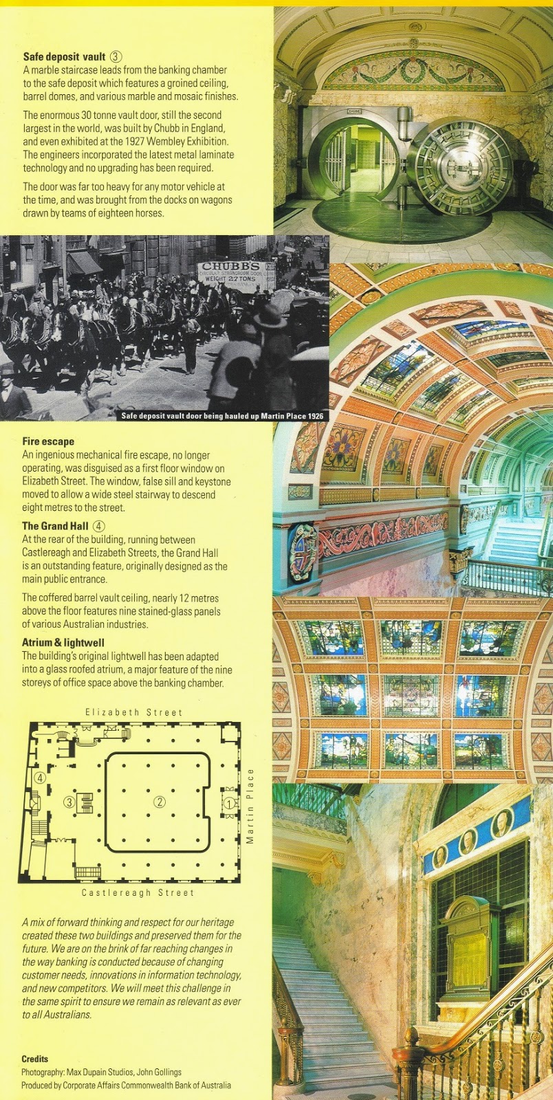
Below: While photography inside the Commonwealth Bank's 48 Martin Place branch is prohibited, this free, full-colour brochure is available to visitors, detailing the history and architecture of this ornate and impressive building.
 |
| The Downing Centre, an Art Nouveau building at the intersection of Elizabeth Street and Liverpool Street. Built in 1908 for the Mark Foy's department store, the original two-storey building was extensively renovated in 1924. With the closure of Mark Foy's in 1980 and, subsequently, the Grace Bros. department store in 1983, the building was renovated for use by state government courts, housing courtrooms, a law library, and court services and Sheriffs' offices. The building re-opened in its new capacity in 1985. |
 |
| Sydney Town Hall, at the intersection of George Street and Druitt Street, and situated next to the Anglican St. Andrew's Cathedral. Sitting atop the site of Sydney's first cemetery, the Old Sydney Burial Ground (1789-1820), the Second Empire style building was constructed from brick and local yellowblock sandstone in two stages between 1869 and 1889; however, city council began occupying the building in 1875. Designed to showcase the wealth and status of the growing city, Sydney Town Hall houses the chambers of the Sydney City Council, Centennial Hall, offices for the Lord Mayor and elected councillors, and reception rooms. Until the completion of the Sydney Opera House in 1973, Sydney Town Hall's Centennial Hall was the city's pre-eminent concert venue. |
 |
| The south side of the Queen Victoria Building (also known as the 'QVB'), at the intersection of George Street and Park Street. Spanning an entire city block bounded by George, Druitt, Market, and York Streets, the QVB was built in the Romanesque Revival style from 1893 to 1898, during an economic downturn. The elaborate decoration and stonework was chosen to employ a large number of unemployed craftsmen. Dedicated to Queen Victoria to mark her Diamond Jubilee in 1897, the building was officially opened on 21 July 1898 and initially served as Sydney's central market until 1910, when another building assumed this function. However, as early as 1902, the QVB was being criticised as a 'white elephant', with calls being made for its demolition, sale, or re-modelling. |
 |
| A statue of Queen Victoria sitting outside the Queen Victoria Building. The last royal statue to be erected in Ireland, and originally installed on the grounds of the parliament buildings in Dublin in 1908, Irish nationalists forced the removal of the statue in 1948. After decades in storage, requests from the Lord Mayor of Sydney and the company renovating the Queen Victoria Building led the Irish government to agree to a long-term loan of the statue to Australia in 1986. Transported by sea to Sydney and restored, the statue was unveiled in its current location on 20 December 1987. |
 |
| In the QVB's early years, tenants included shops, studios, offices, coffee houses, and workrooms, with the upper floors accommodating respectable services, like bookshops, sheet music shops, piano-sellers and piano-tuners, as well as private teachers' classrooms. The QVB also contained a concert hall, a billiards saloon, a women's gymnasium, and a table tennis hall. Major interior alterations were made in 1917 and 1935, rendering the QVB into an elegant, upscale shopping arcade; however, as late as 1959 the building was again threatened with demolition as its increasingly neglected state began to be viewed as a health and safety hazard. |
 |
Built by Thwaites & Reed of Hastings, England, the Royal Clock is one of two large, ornate mechanical clocks hanging from the roof of the Queen Victoria Building. At the top of every hour from 9am to 9pm, the Royal Clock performs a display of six mechanical diorama scenes from English royal history, accompanied by Jeremiah Clarke's The Prince of Denmark's March, also known as the Trumpet Voluntary.
|
 |
| The Queen Victoria Building's other notable timepiece is the Great Australian Clock, weighing four tonnes and standing ten metres tall. The Great Australian Clock displays 33 scenes from Australian history, as the small figure of an Aboriginal hunter circles the exterior of the clock, symbolising the continuous passage of time. |
 |
| A closer look at the Great Australian Clock hanging from the roof in the Queen Victoria Building. The black discs in the centre spin at varying speeds to show the hour, minute, day, month, and date. Above them, murals depict scenes from Australian history, including Captain Cook's landing at Botany Bay in 1770 (right), and the Second Fleet landing in 1790 (left). |
 |
| Empty cafe tables await patrons during an early morning at the Queen Victoria Building. In the background, a giant Christmas tree adorned with Swarovski crystal candles rises from the ground floor under the large dome located at the centre of the building. |
 |
| This view from the second level shows a good example of the ornate tiling on the floor and the cast-iron railings. Following heated debates as to the future of the QVB and a public campaign, Sydney's Lord Mayor announced in May 1971 that the building would be preserved. After lengthy negotiations, a 99-year profit-sharing lease was signed in August 1983 between the city and a Malaysian developer to restore the QVB, and an A$86 million restoration project was completed between 1984 and 1986. A further A$48 million renovation was carried out in 2008-09. Today, the QVB houses brand name stores, high-end fashion houses, restaurants, and upscale boutiques. |
 |
| This view of the Queen Victoria Building's George Street facade shows the ornate exterior decoration, as well as the copper-sheathed domes gracing the roof. The central dome measures 62 feet in diameter and 196 feet from ground level to the top of the cupola. While covered in copper on the outside, the inside of the dome is stained glass. |
 |
| The Sydney Hospital on Macquarie Street. Founded in 1788 on George Street in The Rocks by Governor Phillip to treat convicts suffering from scurvy, typhoid, dysentery, and smallpox, the portable, tent-based hospital was not ideal. In 1811, following the British government's refusal to provide money for a permanent hospital, Governor Macquarie signed a deal with local businessmen to construct a hospital on Macquarie Street in exchange for a monopoly on the importation and sale of rum to the colonists - the origin of the name 'Rum Hospital'. Although a hospital comprising three buildings was completed in 1816, the deal was not profitable for the businessmen and the shoddy construction of the hospital necessitated expensive repairs later on. The original centre building of the hospital was demolished in 1879 and replaced in 1894 with the current building (pictured above). The 113-bed hospital today specialises in ophthalmology and hand surgery. |
 |
| Il Porcellino (Italian for 'piglet), a bronze statue of a wild boar is a replica of the 500-year old original in Florence, Italy. This sculpture was donated by Marchessa Clarissa Torrigiani in 1968 in memory of her father and brother, both well-known surgeons at the Sydney Hospital. Visitors rub the nose for good luck and leave coins in a small basket for children's medical charities. |
 |
| Parliament House, the seat of the New South Wales state government, located on the east of Macquarie Street, to the immediate north of the Sydney Hospital. The oldest part of Parliament House, the two-storey Georgian centre portion, was originally built as the north wing of the Sydney ('Rum') Hospital and completed in 1816. Beginning in August 1829, the New South Wales Colony's Legislative Council began meeting in the building. The subsequent mid-1800s construction of Neo-Gothic additions at either end of Parliament House provided room to house the chambers of the Legislative Assembly (Lower House) and the Legislative Council (Upper House) comprising the bicameral parliamentary structure. The Legislative Assembly sits in the northern addition, while the Legislative Council sits in the southern addition. In 1980, a 12-storey office block was completed at the rear of the complex, to house parliamentary staff and offices. The original 1816 building in between now contains rooms for small committee meetings and events on the ground floor, while Hansard, the parliamentary record of discussion, uses the upper floor. |
 |
| The Sydney Mint on Macquarie Street, built from 1811 to 1816 as the southern wing of the Sydney ('Rum') Hospital. In the early 1850s, the British Secretary of State granted permission for the construction of a mint in Sydney and, in 1854, this was established in the southern wing of the hospital, with a coining factory being installed in the rear. With the mints in Perth and Melbourne featuring more modern equipment and better profit margins, the Sydney mint was closed in 1926 and used by a rotating series of various government offices until a public campaign saved it from demolition in 1979. Now the headquarters of the Historic Houses Trust of New South Wales, portions of the Sydney Mint building are open to the public. |
 |
| The Pitt Street Mall is a pedestrianised block-long section of Pitt Street between Market and King Street. Many brand name chains and upscale boutiques front onto the Pitt Street Mall, as well as a number of shopping centres and arcades. Due to its relatively short length and high volume of customers, the Pitt Street Mall commands the highest commercial rents in Australia. |
 |
| The Pitt Street Mall is lined by historic buildings now housing shops, cafes, and restaurants. Here the Soul Pattinson Chemist (pharmacy) still occupies its original building, constructed in 1886, while the 1905-vintage building immediately to the right houses a lunch counter and part of Australian women's clothing retailer Sportsgirl. |
 |
| The Strand Arcade's Pitt Street Mall entrance. The shopping centre was named after the road linking the City of London and the City of Westminster in London, England. |
 |
| Running the length of the block between the Pitt Street Mall and George Street, the Strand Arcade was opened on 1 April 1892 as the last Victorian-era shopping arcade arcade built in Sydney. |
 |
| The ground floor of the busy Strand Arcade, hosting upscale boutiques, cafes, and restaurants. The tinted glass roof reduces glare, while intricately-carved cedar storefronts, cedar staircases, delicate ironwork balustrades, mosaic tile floors, and marble columns give the building a luxurious feel. |
 |
| Looking down from the top level of the Strand Arcade. Today's trendy shopping arcade was actually threatened with demolition after having fallen into disrepair by the 1970s. While a major fire on 25 May 1976 nearly destroyed the building, restoration efforts resumed and the Strand Arcade re-opened in 1977. |
 |
| Dusk falls over the skyline of Sydney's Central Business District, as seen from a ferry in Sydney harbour. |
 |
A curious cafe/boutique specialising in high-quality chocolate, Max Brenner is a subsidiary of Israeli food and beverage conglomerate the Strauss Group. With 50 international locations, of which 38 are in Australia, Max Brenner serves a variety of signature chocolate-based menu items, including waffles, crepes, milk shakes, hot chocolate, and fondues. This location is on Level 6 of the Westfield Sydney shopping centre. This photo was taken after 10pm on a weeknight and explains why there are no other patrons present.
|
 |
| A paper napkin from Max Brenner. |
Hyde Park
Along with Macquarie Place in the Central Business District, the 40-acre Hyde Park is the oldest public parkland in Australia. It is the southernmost component of a contiguous greenspace running to the shoreline of Sydney harbour that includes the Royal Botanic Garden and The Domain. Named after London, England's Hyde Park, New South Wales Governor Lachlan Macquarie dedicated Sydney's Hyde Park on 13 October 1810 for the 'recreation and amusement of the inhabitants of the town and a field of exercises for the troops.' The park features a broad, tree-lined promenade running its length from north to south, as well as numerous lawns, gardens, and pathways. Nearly 600 giant Hills Fig trees and various species of palms grow in Hyde Park.
 |
| The Anzac Memorial, located at the south end of Hyde Park. The Art Deco design was chosen in 1929 from 117 submissions to an international competition, and funded by a public donation campaign that had begun on the first anniversary of the 25 April 1915 Gallipoli landings. Constructed between 1930 and 1934, the red granite-clad concrete memorial was unveiled by HRH Prince Henry, The Duke of Gloucester on 24 November 1934. Originally dedicated to the men of New South Wales who served during the First World War, the memorial was rededicated in 1984 to all Australians who serve the country in war. The base of the memorial houses offices of veterans' organisations, as well as a small, free museum displaying the stories and mementos of Australian military personnel, from the First World War to Afghanistan and Iraq. |
 |
| The domed Hall of Memory is clad in white marble and contains alcoves on which are inscribed the names of the battles in which Australian forces fought in the First World War. The 120,000 stars on the dome represent each of the Australian men and women who served overseas during the First World War. A white marble balustrade rings the Well of Contemplation which looks down into the Hall of Silence. |
 |
| The sculpture 'Sacrifice' depicts an Anzac soldier laid over a sword and shield, representing the spirit of sacrifice, courage, and endurance. The pedestal supporting the sculpture contains three female figures representing the soldier's mother, sister, and wife, and the figure of an infant, representing future generations. The bronze ring on the floor represents the flames of destruction. Visitors who enter via the stairs into the Hall of Memory must automatically bow their heads to look down into the Hall of Silence. |
 |
| The reflecting pool in front of the Anzac Memorial. |
 |
| A statue of the Royal Navy's Captain James Cook, the explorer, navigator, and cartographer who discovered the east coast of Australia in April 1770 on the first of three epic Pacific voyages between 1768 and 1779. Cook was killed by native Hawaiians during a quarrel on 14 February 1779. |
 |
| The nation's oldest museum, the Australian Museum was founded in 1827, specialising in natural history and anthropology. Its current building, at the intersection of College Street and Park Street across from Hyde Park, was constructed in the 1840s, and opened to the public in May 1857. Although the original building (pictured) was constructed in the Greek Revival style, subsequent additions in 1868, 1890, 1963, and 2008 gave the museum a diverse range of architectural styles. |
 |
| Palms line College Street across from Hyde Park, while St. Mary's Cathedral stands in the distance. Helpful signposts like that pictured here are scattered throughout the city and help visitors orient themselves and find notable attractions. |
 |
| St. Mary's Cathedral of the Archdiocese of Sydney, located across from the northeastern end of Hyde Park. The current cathedral, built out of sandstone, sits on the site of previous Catholic churches built between the 1820s and 1860s. The cornerstone for St. Mary's was laid in 1868 and the dedication Mass was held on 8 September 1882. However, construction continued on additional elements of the cathedral until 1928, and decoration of the crypt was not completed until 1961. In 2000, The squared-off towers of the façade finally received the pinnacles intended in the original design. |
 |
| Sandringham Gardens were unveiled by Queen Elizabeth II on 5 February 1954 and commemorate King George V and King George VI. |
 |
| A side view of St. Mary's Cathedral, as seen from Hyde Park. |
 |
| The wide promenade running the length of Hyde Park, lined with streetlamps and towering fig trees. Following the discovery and removal of several diseased trees in 2005, a study of the park's remaining trees revealed that many were similarly suffering from fungal infections. A 2006 management plan will see the gradual removal and replacement of 230 trees. Signs in the park warn against walking under the fig trees during or immediately after heavy storms on account of the risk of falling limbs. |
 |
| The Sydney Tower, as seen from the north end of Hyde Park. The second tallest observation tower in the Southern Hemisphere (after Auckland's Sky Tower) and the tallest structure in Sydney at 1,014 feet, the Sydney Tower was designed in 1968. Constructed between 1975 and 1981 atop the Westfield Sydney shopping centre, the tower is a popular tourist destination, offering 360 degree views of the city and its harbour. Sydney Tower comprises three levels housing various bars and restaurants and a fourth, uppermost level containing the observation deck and gift shop. |
 |
| The J.F Archibald Memorial Fountain at the northern end of Hyde Park, named after the Francophile owner and editor of The Bulletin magazine, who left money in his will for the construction of a fountain dedicated to the association of Australia and France during the First World War. As specified in Archibald's will, the fountain was completed by a French sculptor and unveiled on 14 March 1932. |
 |
| The focal point of the Art Deco fountain is a statue of the Greek god Apollo (god of the arts and light), clutching the Lyre in its left hand. Arranged around the basin are additional sculptures, including Diana (goddess of purity), and Theseus slaying the Minotaur. Horses' heads, tortoises, and dolphins also spray water in this lively fountain. |
 |
| An ibis walks through the colourful flower beds surrounding the Archibald Fountain in Hyde Park. |
 |
| A cafe on the western edge of Hyde Park. |
 |
| The entrance to St. James Station, located on the western edge of Hyde Park, at Market Street. |
 |
| A statue of Queen Victoria at the corner of Macquarie Street and St. James Road, across from the northern tip of Hyde Park. |
 |
| Across the street from the Queen Victoria statue is a statue of Albert, Prince Consort of Queen Victoria. |
 |
| The Hyde Park Barracks Museum, at Macquarie Street and Prince Albert Road. The brick building and compound was designed by convict architect Francis Greenway in 1818-1819 and built by convict labourers at the direction of New South Wales Governor Lachlan Macquarie. It housed convict labourers working for the government until 1848. Subsequently, the building served as an immigration depot, female asylum, law courts, and government offices. |
 |
| Currently operated as a museum by the Historic Houses Trust of New South Wales, Hyde Park Barracks Museum is listed on the UNESCO World Heritage List as one of 11 pre-eminent Australian Convict Sites. |
 |
| A statue of Major-General Lachlan Macquarie, Governor of New South Wales from 1810 to 1821, located at the northern entrance to Hyde Park. |
Royal Botanic Gardens and The Domain
 |
| An equestrian statue of King George V near the Conservatorium Gate entrance to the Royal Botanic Garden. |
 |
| The Palace Garden Gate entrance to the Royal Botanic Garden. |
 |
| Towering cycads and palms line a grassy open area inside the Royal Botanic Garden. |
 |
| The Rose Garden and Pavilion. |
 |
| The Governor Phillip Fountain, originally unveiled on 22 June 1897 in honour of the first Governor of New South Wales. The most expensive public sculpture in Australia in the 19th century, the Governor Phillip Fountain was crafted out of bronze and Italian marble, cost £14,000, and took seven years to complete. The smaller sculptures depict mythological figures representing mining, commerce, agriculture, and navigation, as well as representations of sheep, wheat, waratahs (native shrubs), and Aborigines. |
 |
| A variety of paths criss-cross the Royal Botanic Garden. Here, in the Palm Grove, the main path continues eastward to the succulent and early colonial food crop gardens, while the path on the left heads north to the central section of the Garden and the path on the right leads south into the Rainforest Walk trail. |
 |
| Dappled sunlight filters through the canopy of palm fronds in the Rainforest Walk. |
 |
| The Palm Grove, established in 1862, is one of the oldest parts of the Royal Botanic Garden, with many of the trees having been cultivated from seeds and seedlings collected in the 1820s and 1850s. |
 |
| An Indian Fig (opuntia ficus-indica), a species of prickly pear. Introduced to Australia because they host the cochineal beetle used to produce a valued red dye, the prickly pear rapidly spread over 24 million hectares of New South Wales and Queensland. Toxic herbicides were used at first to stop the spread of the prickly pear, later replaced by a species of moth imported from Argentina. |
 |
| Bananas were brought by early settlers in New South Wales. |
 |
| A tobacco plant, another species introduced by early settlers from Britain. Easily-cultivated tobacco was well-established in the Sydney area as both an ornamental and agricultural crop by the early 1800s. |
 |
| Sugarcane was brought to New South Wales from South Africa but was not successfully cultivated as a commercial crop until 1821. Despite surviving in Sydney, the city's low midwinter temperatures and poor soil are insufficient to promote vigorous growth. |
 |
| A coffee tree. Coffee trees were brought to the Sydney area from Rio de Janeiro, but they only produced poor quality harvests. Despite colonial attempts to establish coffee as a commercial crop, efforts only succeeded after farmland was opened up in northern Queensland in the late 1800s. |
 |
| Visitors can stroll through the Palm Grove via a number of paved paths. |
 |
| A 'trackless train' trundles down one of the garden pathways. These open-air vehicles allow visitors to see different parts of the Royal Botanic Garden without having to endure a lot of walking. |
 |
| The variety of palms species is evident in this photo. |
 |
| A Wollemi pine (Wollemia nobilis), one of the world's rarest species, with only a few stands of adult trees in the wild. Previously found only in fossils, wollemi pines were thought to have been extinct for millions of years until a stand of trees was found in 1994 by a hiker in Wollemi National Park, 150 kilometres northwest of Sydney. Isolated in canyons, the wollemi pines are severely inbred. |
 |
| The Garden Shop, selling a variety of books, seeds, gifts, garden tools, and housewares. |
 |
| The Botanic Garden Restaurant and Cafe, located in the centre of the Royal Botanic Garden and surrounded by palms and other trees. |
 |
| A stone obelisk containing the remains of botanist Allan Cunningham, located in a pond next to the Botanic Garden Restaurant and Cafe. |
 |
Water lilies cover the surface of a pond, while benches on surrounding pathways and in leafy alcoves provide a quiet place to read or enjoy a warm spring day in the Royal Botanic Garden.
|
 |
| The Main Pond in the central section of the Royal Botanic Garden provides a habitat for waterfowl. |
 |
| The serenity of a quiet pond fringed by tall, stately palms contrasts with the modern skyscrapers along Macquarie Street in the distance. |
 |
| Looking north along the sea wall separating the Royal Botanic Garden from Farm Cove in Sydney harbour. The peak of the Sydney Opera House can just be seen beyond the trees. |
 |
| A massive Moreton Bay Fig (ficus macrophylla) tree, a species of banyan tree native to the eastern coast of Australia and named after Moreton Bay in Queensland. Moreton Bay Fig trees can reach 200 feet in height. |
 |
| Two palms frame a view of the glass and steel skyscrapers of the Central Business District on a bright, cloudless day. |
 |
| Large cycads. The small white sign in front of the plants warn that the cycads' colourful seeds are poisonous and should not be touched. |
 |
| A display of cycads, one of the world's oldest plant species. |
 |
| The central section of the Royal Botanic Garden features manicured lawns and colourful flower beds, as well as isolated stands of palms and other trees. A copy of the Choragic Monument of Lysicrates (the original of which stands in Athens, Greece and dates from 334 BC) was carved in 1870 by a local stonemason from Pyrmont yellowblock sandstone. |
 |
| The Sydney Harbour Bridge and Opera House are visible over this bank of colourful flowers in the Royal Botanic Garden. |
 |
| The main gate to Government House, the official residence of the Governor of New South Wales, located within the Royal Botanic Garden. While the public is able to wander the grounds, free 45-minute guided tours of the principal public rooms of the house are only available by obtaining a ticket at the gatehouse security desk, for which visitors are required to provide photo identification. Photography of the grounds and exterior of the house is permitted, but interior photography is not allowed for security reasons. |
 |
| The broad, well-tended front lawn of Government House. |
 |
Designed in 1834 by Edward Blore, architect to King William IV, Government House was constructed on the grounds of the Royal Botanic Garden on Bennelong Point beginning in September 1836. Built from locally-quarried sandstone, Government House was the most sophisticated example of Gothic Revival architecture in Australia at that time, and cost £46,000 by the time it was complete in 1845. The covered entry was added in 1872 to protect carriage-borne visitors during inclement weather.
With the federation of the Australian states in 1901, the government of New South Wales, believing that the capital of the Commonwealth of Australia was naturally Sydney, offered Government House rent-free to the national government as the official residence of the Governor General. (The New South Wales Governor's residence was relocated to Cranbrook, Rose Bay.) In 1915, with Canberra having been selected to host the Commonwealth capital and a Governor General's residence having been built there, the Governor of New South Wales moved back into Government House. In January 1996, the Premier of New South Wales decided to end Government House's role as the private residence of the Governor and to open the house and grounds to the public. In December 2013, Government House once again became the official residence of the Governor, and it is now used to host Vice Regal ceremonies, receptions, and luncheons, as well as the weekly meetings of the New South Wales Executive Council (Cabinet). |
 |
| A Moreton Bay Fig tree, located near the front entrance of Government House. The oldest tree on the property, it was planted shortly after Government House was completed in 1845. |
 |
| The eastern covered arcade was constructed in 1879 as part of a redecoration and renovation project in advance of the Sydney International Exhibition. |
 |
| The covered arcade on the east side of Government House is a pleasant, shady place to enjoy views of the gardens and harbour beyond. Doors lead into a large, impressive room used for formal events, including investiture ceremonies and concerts. |
 |
| The covered arcade on the east face of Government House provides lovely views of the gardens and the sparkling blue waters of Sydney harbour beyond the trees. |
 |
| The gardens on the eastern terrace include manicured flower beds, trees, a fountain, and stone pathways. The eastern terrace and fountain were constructed in 1861. |
 |
| A view of the eastern side of Government House from the perimeter of the gardens. |
 |
| Mrs. Macquaries Chair, a sandstone outcropping hand-carved by convicts into a bench overlooking Sydney harbour. It was carved for the wife of the Governor of the New South Wales colony in 1810 so that she could enjoy viewing the harbour. |
 |
| The Fleet Steps, linking Farm Cove to Mrs. Macquaries Road. The Fleet Steps was the point at which Queen Elizabeth II first stepped foot on Australian soil, 3 February 1954. |
 |
| A view of the clear water and natural rocky ledges along the edge of this part of Sydney harbour, as seen from the walking path running along the western edge of Woolloomooloo Bay. |
 |
| The Adelaide-class frigate HMAS Melbourne, moored alongside the Garden Island naval base in Sydney harbour. Ordered in 1980, Melbourne was originally to be named Torrens, as the aircraft carrier HMAS Melbourne was still in service. After the carrier's decommissioning in 1982, the frigate hull was renamed Melbourne and the 4,200 ton vessel was launched 5 May 1989 and commissioned into the Royal Australian Navy on 15 February 1992. |
 |
| The Woolloomooloo Wharf, built in 1910 by the Sydney Maritime Trust as a wool and cargo-handling facility, has been renovated and transformed into the Blue Sydney, an upscale hotel, as well as prominent entertainment destination, luxury marina, and apartment complex. |
 |
| A towering succulent stands near the Lewis Wolfe Levy fountain, commissioned by the family of businessman and politician Lewis Wolfe Levy in 1889. Four ornate drinking fountains are mounted on the corners of the base. |
 |
| The Woolloomooloo Gate entrance to the Royal Botanic Garden. |
 |
| Located immediately adjacent to the Royal Botanic Gardens, the 34 hectares of land comprising The Domain were originally set aside in the period after 1788 by Governor Arthur Phillip for the exclusive use of Governors of New South Wales. Known as Phillip Domain, the land was cleared of trees and eventually opened to the public in the 1830s as a popular site for picnics, concerts, and other leisure activities. Today, The Domain is smaller than it was in the late 1700s, as urban development gradually subsumed the portion west of Macquarie Street. |
 |
| The Art Gallery of New South Wales, housing a diverse selection of Australian, European, and Asian art. The building's first two galleries opened in 1897, with subsequent galleries opening in 1899, 1901 and 1902, and a major new addition being added as a Bicentennial project in 1988. |
 |
| The Royal Australian Navy Anzac-class frigate HMAS Parramatta, docked at the Garden Island naval base. This 3,600 ton vessel was built in Williamstown, Victoria, and commissioned on 4 October 2003. The ship is operated by a crew of 170 and sports a 5-inch deck gun, Harpoon anti-surface missiles, Evolved Seasparrow point defence missiles, and torpedoes. |
National Maritime Museum and Darling Harbour
 |
| A view of the Central Business District, as seen from Darling Harbour. The shoreside building in the centre is the Wild Life Sydney Zoo, opened in September 2006 and located next to the Sydney Aquarium and Madame Tussauds Sydney. It features a one kilometre walkway through 75,000 square feet of enclosures, exhibiting red kangaroos, Tasmanian devils, koalas, wallabies, cassowaries, crocodiles, and various butterflies and insects. |
 |
| A view of some of the development and maritime activity in Darling Harbour. |
 |
| The 224-foot long S.S. South Steyne, the world's largest operational steam ferry, was built in Leith, Scotland for the Port Jackson and Manly Steamship Company and launched on 1 April 1938. Arriving in Australia on 19 September 1938 after a 22,000 kilometre voyage, South Steyne operated between Circular Quay and Manley for 36 years, making over 100,000 trips and carrying over 92 million passengers. After a fire on 25 August 1974, South Steyne was taken out of service. Restored in the late-1980s, the ship served as a floating restaurant in Melbourne and Newcastle before steaming back to Sydney to serve as the Sydney 2000 Olympic Information Centre until mid-1997. Today, South Steyne is a floating restaurant next to Pyrmont Bridge in Darling Harbour. |
 |
| The Oberon-class diesel-electric submarine HMAS Onslow and the Daring-class destroyer HMAS Vampire, both formerly of the Royal Australian Navy, are now permanently moored alongside the Australian National Maritime Museum in Darling Harbour. |
 |
| The main entrance to the Australian National Maritime Museum (ANMM), established in 1991. The ANMM is one of six federally-managed museums in Australia, and the only one located outside the Australian Capital Territory (i.e. Canberra). |
 |
| One of the original anchors from HMS Sirius, flagship of the 11-vessel First Fleet, which delivered the first consignment of convicts, guards, and officials to Australia in 1788. |
 |
| The entrance to a non-permanent gallery covering the history of the Royal Australian Navy in the First World War. |
 |
| A wooden stern ornament from the German cruiser SMS Emden, sunk by the Royal Australian Navy light cruiser HMAS Sydney on 9 November 1914. The ornament was taken by Sydney's crewmen as a souvenir of the battle. The ornament features a German imperial crown above a stylised 'W' for Kaiser Wilhelm II. |
 |
| A diorama depicts personnel of the Royal Australian Navy Bridging Train, a logistical support and combat engineering unit that operated in the Gallipoli and Palestine Theatres of the First World War. The RANBT comprised naval reservists under the command of Lieutenant-Commander Leighton Bracegirdle, and was the most decorated Royal Australian Navy unit during the war. |
 |
| The entrance to the Navigators gallery features a giant globe. The gallery examines the discovery, exploration, and charting of Australia's coast by Dutch, British, and French navigators, as well as trade between native Indonesians and Australian Aborigines before the era of European discovery. |
 |
| A view inside the Navigators gallery. |
 |
| A display of navigational tools from the Days of Sail, including sextants used to measure the angle between the horizon and a celestial object in order to plot one's latitude. |
 |
| A scale model of His Majesty's Barque Endeavour, the research vessel commanded by Lieutenant James Cook on his first voyage of discovery to Australia and New Zealand, 1769-1771. While the original Endeavour was scuttled off Newport, Rhode Island in 1778, a fully-functional replica was launched in December 1993 and now belongs to the Australian National Maritime Museum, making periodic sailings in Australian waters. This model was built by the staff of the National Maritime Museum in Greenwich, UK and presented by Queen Elizabeth II to the people of Australia in 1970 to mark the 200th anniversary of Cook's landing in Botany Bay. |
 |
| The Eora First People gallery displays Aboriginal and Torres Strait Islander artefacts associated with the sea, including carved and painted Pukumani burial poles, hollow log coffins, ceremonial sculptures, and handwoven artwork. |
 |
| The original British-made first order Fresnel lens from the Tasman Island Lighthouse. The 95-foot tall Tasman Island Lighthouse was built in 1906 off the southeastern coast of Tasmania and was automated in 1976. |
 |
| A figurehead depicting famous British naval hero Admiral Horatio Nelson. This figurehead was mounted on the Royal Navy first rate ship of the line HMS Nelson, constructed in 1814, converted to a screw warship in 1860 and, in 1865, given to the Australian colony of Victoria as a training ship. After years as a frigate, coal lighter, and coal storage hulk, the ship was scrapped in 1928. |
 |
| The Passengers gallery, devoted to telling the stories of generations of immigrants who arrived in Australia by sea. The gallery, designed in an Art Deco style, contains numerous diaries, articles of clothing, mementos, and shipboard souvenirs. |
 |
| A large scale model of the 23,832 tonne Orient Steam Navigation Company ocean liner S.S. Orcades. The liner, built in 1937, could carry 463 First Class and 605 Tourist Class passengers, along with a crew of 466. The Orcades made five return voyages from the UK to Australia between 1937 and 1939, before being requisitioned by the British government as a troopship. She was torpedoed in 1942 near Cape Town, South Africa, with the loss of 48 lives. |
 |
| A view inside the cavernous building of the Australian National Maritime Museum, housing a diverse range of artefacts, from wooden figureheads to a maritime helicopter. |
 |
| Housed in the ANZ Tall Gallery, the Blackmores First Lady is a 11.28 metre Cavalier 37 sailboat, built in 1984. In 1988, Kay Cottee used this boat to become the first woman to circumnavigate the globe solo, without touching land or receiving any assistance. Following months of customisation, including the installation of watertight crash bulkheads, stronger rigging fittings and rudder post, a steel beam to secure the mast step, fresh water tanks, a plexiglass dome, extra hand-holds, and modern communications and navigational gear, Cottee departed Sydney on 29 November 1987 and spent the next six months on her epic voyage, returning to Sydney on 5 June 1988. Visitors to the ANMM can, with a museum guide, climb inside the sailboat to see how Cottee lived during her voyage, the cabin having been recreated using most of the original items she carried. |
 |
| A Belmont Dorsett Caribbean ski runabout, one of the first fibreglass runabouts to be mass-produced in Australia during the boom years of the 1950s and 1960s. Mass production allowed thousands of middle class Australians to get out on the water in affordable and easy-to-care-for boats. |
 |
| A Westland Wessex Mark 31B anti-submarine warfare helicopter of the Royal Australian Navy. The Royal Australian Navy operated Wessex helicopters between 1963 and 1989 in the anti-submarine warfare training, air-sea rescue, and utility roles. The helicopters were instrumental in supporting the rescue effort following the 10 February 1964 collision between the aircraft carrier HMAS Melbourne and the destroyer HMAS Voyager, as well as in the disaster assistance mission in Darwin following Cyclone Tracy in 1974. |
 |
| The ship's bell from the United States Navy cruiser USS Canberra, named in honour of the Australian cruiser HMAS Canberra, which was sunk at the Battle of Savo Island on 8-9 August 1942. USS Canberra is the only US Navy warship to have been named after a foreign capital or foreign warship. The 250-pound brass bell was donated to Australia by the United States in a handover ceremony between US President George W. Bush and Australian Prime Minister John Howard on 10 September 2001. |
 |
| The Darling Harbour exterior of the Australian National Maritime Museum. Moored alongside the museum building is a fleet of historic vessels. |
 |
| The Attack-class patrol boat HMAS Advance, commissioned on 24 January 1968 and decommissioned on 6 February 1988. During her active career, HMAS Advance was stationed in Darwin and patrolled the waters off northern Australia. The 146-ton (full load) vessel is 107.6 feet long, and powered by two 16-cylinder Paxman diesel engines capable of propelling the boat at 24 knots. Advance carried a crew of 3 officers and 16 sailors and was armed with one 40mm Bofors gun and two .50-calibre M2 Browning machine guns. |
 |
| During an eventful career, HMAS Advance shadowed a Soviet trawler for two months in the Gulf of Carpentaria in 1968; survived Cyclone Tracy's devastation of Darwin on 25 December 1974; participated in anti-illegal fishing patrols in 1975-76; portrayed the fictional HMAS Ambush in the Australian TV series 'Patrol Boat' in 1979; and in 1980 was reassigned to Sydney as a naval reserve training vessel. |
 |
| HMAS Advance is maintained in operational condition and is open for guided public tours. Along with the other historic vessels in the museum's collection, she is included with the Big Ticket admission option. |
 |
| HMAS Onslow, an Oberon-class submarine, commissioned on 22 December 1969 and decommissioned on 30 March 1999. The boat, built in Greenock, Scotland as the last of four ordered by Australia in 1963, is named after the town of Onslow in the state of Western Australia and Sir Alexander Onslow, the third Chief Justice of the Supreme Court of Australia. |
 |
| The Onslow's bulbous bow houses the submarine's sonar array. Note the forward diving planes are folded up. Onslow measures 295.2 feet long, with a beam of 26.5 feet and a draught of 18 feet when surfaced. Displacement is 2,030 tons surfaced, 2,410 tons submerged, and diving depth is 200 metres (660 feet). |
 |
| The torpedo compartment aboard Onslow contains six tubes and space for 20 torpedos, six stored in the tubes and an additional 14 in cradles in the compartment. Originally, she carried the British Mk 8 torpedo, subsequently replaced by the wire-guided Mk 23 torpedo. During a 1982-84 refit, Onslow was modified to take the 21-inch diameter American Mk 48 Mod 4 wire-guided torpedo. During this same refit, the torpedo tubes were also certified to fire the UGM-84 Sub-Harpoon missile, and Onslow became the world's first conventionally-powered submarine to carry this weapon. |
 |
| Aft of the torpedo room is one of the compartments used for accommodating a number of crewmen. Each sailor had his own bunk so the practice of 'hot bunking' was not required. |
 |
| Looking forward up the main passageway aboard HMAS Onslow, with bunks along the port side and various offices on the starboard side. |
 |
| The officers' wardroom provides a place for the Onslow's eight officers to relax and take their meals. |
 |
| The fire control consoles in the control compartment. |
 |
| The navigator's chart table on the starboard side of the control compartment. |
 |
| The captain's cabin, cramped by surface ship standards but offering the most privacy of any accommodation space aboard Onslow. |
 |
| One of the two Admiralty Standard supercharged V16 diesel generators which power two English Electric motors, providing 4,500 shaft horsepower and propelling Onslow at 12 knots when surfaced and 17 knots when submerged. |
 |
| The propeller motor control panel, located in the aft section. Onslow's diesel-electric engines gave the boat a range of 9,000 nautical miles at 12 knots. |
 |
| A port side view of the destroyer HMAS Vampire, as seen from the other side of Darling Harbour. The 3,560 ton (full load) Daring-class destroyer was commissioned on 23 June 1959, converted to a training role in 1980, and decommissioned on 13 August 1986. Vampire measures 388 feet 11.5 inches long, with a beam of 42 feet 11.375 inches, and a draught of 12 feet 9 inches. As originally built, the ship carried three twin 4.5-inch Mk V gun turrets, two single and two twin-mount 40mm Bofors anti-aircraft guns, five anti-ship torpedo launchers, and a Limbo anti-submarine mortar. The torpedo tubes were removed in 1970 and the Limbo mortar in 1980. |
 |
| The Chiefs' Petty Officers' Mess aboard HMAS Vampire. |
 |
| The aft 4.5-inch handling room. The majority of this compartment is consumed by the ammunition hoists and rails, which are used to bring shells and propellant charges up from the magazines below and ready them for conveyance to the twin 4.5 inch gun turret above. The shells are sent up to the turret via the forward hoist, while propellant charges are sent up via the after hoist. |
 |
| Vampire's sick bay. |
 |
| A wash space containing sinks and showers. |
 |
| The cafeteria-style galley was a most efficient way to serve the hundreds of daily meals to the 300 sailors aboard. |
 |
| A mess where the ship's sailors ate their meals and relaxed when off duty. |
 |
| The Captain's Day Cabin, used by Vampire's commanding officer when the ship was in port or when entertaining guests. A smaller cabin, located much closer to the bridge, was the captain's ordinary accommodation when the ship was at sea. |
 |
| The starboard side of the officers' wardroom aboard HMAS Vampire. |
 |
| The port side of the officers' wardroom, featuring a long, upholstered settee running the length of the cabin. |
 |
| Vampire's forward twin 4.5-inch 'A' turret. |
 |
| The nerve centre of the ship, the Operations Room, is where Vampire would have been commanded when at action stations. A variety of sensors and computers feed information to the personnel manning the Operations Room, allowing the commanding officer to make decisions concerning navigation, targeting, and damage control. |
 |
| A view of the ship's forward mast, featuring many of the sensors and radar dishes carried aboard. The spherical radome, one of two on Vampire, houses search and tracking antennae for the M22/5 naval fire control radar system. The antennae, which operate out to a range of 400 kilometres, feed information to the computerised control systems that direct the guns. |
 |
| The Vampire's bridge, with the Captain's Chair occupying a raised position in the centre for clear visibility on all sides. |
 |
| Looking forward, out the bridge windows. A compass platform stands in the centre, with various radios and pieces of navigational equipment bolted to the bulkheads. |
 |
| The Krait, a former Japanese fishing boat originally named Kofuku Maru. Seized by the British during the Second World War, the boat was renamed Krait after a deadly Indian snake and outfitted for use in Operation Jaywick, a nighttime surprise raid on shipping in Singapore harbour. After departing from Exmouth Gulf in Western Australia with an eight-man mixed crew of British and Australian Navy and Army personnel and six commandos, Krait entered Japanese-controlled waters posing as a Japanese fishing boat. On the night of 26 September 1943, the commandos used folding canoes to paddle into Singapore harbour, where they placed limpet mines on several vessels. The resulting explosions sank two enemy ships and damaged another five. After the war, Krait was found working in Borneo in the logging trade, and was brought to Sydney in 1964. In 1985, the vessel was donated to the Australian War Memorial and then transferred to the Australian National Maritime Museum. |
 |
| The wooden Motor Boat 172 was built by the Garden Island Dockyard in Sydney in 1937 as a District Officer's Boat. After serving in Papua New Guinea throughout the Second World War, the boat returned to Sydney where it was used as a Senior Officer's Boat, transporting senior Royal Australian Navy officers and VIPs from ship to shore and around the harbour. Decommissioned in the late 1980s, stripped of usable equipment, and placed in storage, MB 172 was later restored by apprentice shipwrights at Australian Defence Industries in Ryde and donated to the Australian National Maritime Museum. |
 |
| The 14.6 metre ex-Royal National Lifeboat Institution (RNLI) Solent-class lifeboat Sea Guardian. The Sea Guardian was built in 1969 and served in Ireland before being transferred to Australia in 1993. |
 |
| A view of HMAS Advance, Onslow, and Vampire in Darling Harbour. |
 |
| The full-scale replica of His Majesty's Barque Endeavour, based at the Australian National Maritime Museum. Built in Australia between 1988 and 1993, this HMB Endeavour has sailed over 170,000 nautical miles, visited 29 countries and numerous Pacific islands, and welcomed visitors aboard in 116 ports. The masts and spars on this accurate reproduction support 28 sails comprising about 10,000 square feet of canvas. |
 |
| Built in Fremantle, Australia and owned by the Australian government, the replica of HMB Endeavour is designed to perfectly reproduce the original, commanded by Lieutenant James Cook on his voyage of discovery to Australia and New Zealand between 1769 and 1771. |
 |
| The replica HMB Endeavour displaces 550 tonnes, has an overall length of 109 feet 3 inches, a beam of 29 feet 2 inches, and a draught of 11 feet 10 inches. The mainmast, the tallest of the vessel's three masts, is 127 feet 11 inches tall. The ship carries a crew of 16 professionals or 36 amateur sailors, with space for 4 additional supernummary passengers, who pay $495 per day for a private cabin and all meals, while being able to choose which sailing duties they would like to participate in. |
 |
Commonwealth Lightship (CLS) 4, Carpentaria was one of four unmanned rivetted steel lightships built at Cockatoo Island Dockyard, Sydney in 1916-17. The 21.94 metre long vessel was originally equipped with an acetylene light, activated by a sunlight-operated valve, and fed by a six-month supply of acetylene gas in onboard tanks. An automatic mechanism controlled the flow of gas to produce a code of light flashes, while a bell tolled with the rolling of the ship. The bright red colour scheme was also easily recognised by sailors during the day. CLS 4 spent much of its life in the Gulf of Carpentaria, but spent the last years of its life in the Bass Strait oilfields as a traffic separator. It was retired in 1985 and replaced by a modern lightship.
|
 |
| The three-masted, iron-hulled barque James Craig, launched in 1874 and one of only four such 19th century barques still sailing today. The James Craig is operated by the Sydney Heritage Fleet and regularly carries passengers on day sails. |
 |
| Built in Sunderland, England and originally named Clan Macleod, the vessel carried cargo around the British Empire. In 1900, she was purchased by Mr. J.J. Craig and renamed James Craig in 1905, after which she operated between Australia and New Zealand until 1911. Rendered unprofitable by the advent of steamships, James Craig was converted to a collier, then used a hulk, and finally abandoned in Tasmania's Recherche Bay. In 1932, fishermen sank the ship after blasting a 3-metre hole in the hull. The James Craig was salvaged in 1972, brought to Sydney in 1981, extensively restored, and re-launched in 1997, with restoration work finally being completed in 2001. |
Manly Beach
 |
| A return ferry ticket to Manly Wharf, 29 October 2014. |
 |
| Passengers watch the Sydney skyline recede as the ferry Queenscliffe whisks them over to Manly Wharf. |
 |
| Sailboats dart past the numerous ferries and sightseeing vessels that ply the waters of Sydney harbour. |
 |
| Featuring good sailing conditions within a large, sheltered harbour, Sydney is home to thousands of sailboats. |
 |
| The Pacific Ocean can be seen beyond the entrance to Sydney harbour. North Head is the rocky plateau on the left. |
 |
| Red tile-roofed beachfront houses and dozens of small pleasure craft moored in Manly Cove give the suburb of Manly a more relaxed feel than the hustle and bustle of Sydney. |
 |
| Manly Wharf, the terminus for passengers taking the Sydney Ferry to Manly Beach. While the wharf is located in Manly Cove inside the harbour, Manly Beach is located on the Pacific coast of North Head at the extreme eastern end of Sydney harbour. |
 |
| The Corso, a pedestrian plaza traversing the peninsula and leading from Manly Wharf to Manly Beach. |
 |
| The Corso is lined with historic buildings housing hotels, restaurants, and bars, as well as the usual assortment of tourist-related souvenir shops, ice cream parlours, and fast-food outlets. |
 |
| The eastern end of The Corso, terminating at Manly Beach. |
 |
| Colourful flags flap in the fresh Pacific breeze coming in over Manly Beach. The beach is divided into three sectors: North Steyne, Queenscliffe, and South Steyne. |
 |
| Surf and sand at Manly Beach. |
 |
| A lifeguard's surf board stands ready in case of emergency on a quiet weekday at Manly Beach. |
 |
| Manly Beach was named by Captain Arthur Phillip, the first governor of New South Wales colony, for the indigenous people living there. According to Phillip, "[the indigenous people's] confidence and manly behaviour made me give the name of Manly Cove to this place." |
 |
| Surf warning flags flap in the stiff westerly breeze. |
 |
| Students of the Manly Surf Club enjoy the waves at Manly Beach. |
 |
| The Ivanhoe Hotel on The Corso in Manly. The building features three floors of indoor and outdoor spaces, including two rooftop bars, a sports bar, and two courtyards. |
 |
| Looking northeast along The Corso as dusk begins to fall over Manly. |
 |
| The Art Deco Manly Wharf building, as seen from The Corso. |
 |
| Passing the Manly-bound ferry Collaroy (1988) amid rising swells and a freshening breeze coming in through the harbour heads. |
 |
| Passengers exit the ferry Narrabeen (1984) at Circular Quay after enjoying the sun and sand of Manly Beach. |
Taronga Zoo
 |
| Approaching Taronga Wharf, located on the north side of Sydney harbour in Athol Bay. |
 |
| The sign welcoming visitors off the ferry. A ramp leads up to the Sky Safari cable car, which transports visitors to the main entrance. Alternatively, a municipal bus route also shuttles between the wharf and the main entrance. |
 |
| The Sydney skyline as seen from the Sky Safari cable car en route to the zoo's main entrance. |
 |
| The Asian elephant paddock in the Taronga Zoo, designed in a Thai theme. |
 |
| The giraffes enjoy a clear view of downtown Sydney across the harbour. |
 |
| Chimpanzees try to stay cool high on a platform in their habitat. |
 |
| The chimpanzee habitat is home to six distinct family units. |
 |
| A Barbary sheep shelters from the hot sun. |
 |
| The mountainous habitat for the Himalayan tahr, a goat-like native of southern Tibet, northern India, and Nepal. |
 |
| A lioness peers at visitors through the glass of the Big Cat pavilion. |
 |
| A sun bear, native to the tropical forests of Southeast Asia. The sun bear gets its name from a light-coloured crescent patch on its chest that resembles a rising sun. |
 |
| The South Seas pavilion, housing various seals, pelicans, and penguins. |
 |
| This large water tank is home to the seals and sea lions that perform daily in a 1000-seat open amphitheatre. |
 |
| Visitors watch a zookeeper demonstration with one of the zoo's seals. |
 |
| An Australian pelican swims in its pool at the Taronga Zoo. This species of pelican holds the record of having the longest bill of any bird species. A hook at the end of the very sensitive bill is used to grab fish in murky water, and the pouch is used as net. During the breeding season, pelicans' bills and pouches change colour. |
 |
| The centre of the park features the Asian elephant paddock and the Taronga Food Market, a cafeteria style restaurant. |
 |
| A bongo, a species of forest antelope and the largest species of African antelope. |
 |
| Native Australian lizards roam freely through the various pavilions at the Taronga Zoo. |
 |
| A zebra takes advantage of the shade from a large tree. |
 |
| A meerkat crouches in the sand, watching visitors peering back. These natives of parts of Botswana, Namibia, Angola, and South Africa can live 12-14 years in captivity. |
 |
| Two Asian elephants seek the shade in their paddock, while the juvenile plays with a large section of plastic pipe. |
 |
| The Taronga Zoo's old Elephant Temple, built in 1915 and big enough to house two elephants. |
 |
| The interior of the Elephant Temple. In the early years of the zoo's existence, up to ten visitors at a time could ride the elephants using specially designed saddles. When the zoo shifted away from an entertainment venue to a conservation facility over 30 years ago, the elephant rides ended and the zoo now contributes to a regional Asian elephant breeding program. |
 |
| The Lemur Forest Adventure exhibit, during a presentation on lemur conservation given by a zookeeper. |
 |
| A ring-tailed lemur sits on a shaded platform in the Lemur Forest Adventure exhibit. |
 |
| A kookaburra perches in a tree. |
 |
| A group of tourists admire two peacocks walking freely around the paths of the Taronga Zoo. |
 |
| The Australian Rainforest Aviary is home to a number of colourful, exotic birds, protected from predators in this covered natural environment. |
 |
| A white-headed pigeon, native to the eastern coast of Australia, from southern New South Wales north to the Cape York Peninsuala. |
 |
| A forest kingfisher, native to the eastern and northern coasts of Australia, from northern New South Wales to the tip of Queensland's Cape York Peninsula and the northern parts of the Northern Territory. |
 |
| An emerald dove. This colourful species lives in a narrow strip along the eastern and northern coasts of Australia. |
 |
| The aviary provides a safe but realistic environment for the zoo's collection of exotic birds. |
 |
| An Australian pelican preens its feathers on a log in its enclosure. |
 |
| The Tasmanian Devil pavilion and research centre, devoted to showcasing this species which is threatened by vehicles and by a devastating facial tumour that is spreading amongst the wild population of devils. |
 |
| Two brush-tailed rock wallabies sit on the boardwalk that snakes through one of the Taronga Zoo aviaries. The brush-tailed rock-wallaby is native to eastern Australia's Great Dividing Range, living on rock piles and ridge lines and using rough, non-skid pads on their feet to easily hop between rocky ledges. |
 |
| A bush stone-curlew, a ground-dwelling Australian native bird. This generally-nocturnal bird uses its mottled plumage to hide in tall grass and shrubs during the day, remaining motionless in often-odd poses when surprised. Bush stone-curlews feed on insects, frogs, molluscs, spiders, snakes, lizards, crustaceans, and small mammals. |
 |
| A waterfall and pond provide a natural environment for the birds and animals in this covered aviary. The zoo's platypus was seen swimming in the pond. |
 |
| A rabbit hutch in the children's area of the zoo. |
 |
| A red kangaroo rests under a tree. |
 |
| A crocodile sleeps on a wooden platform. A second crocodile was sleeping nearby, almost fully submerged in the pond. |
 |
| The koala habitat. |
 |
| A koala bear naps in the crook of a tree within the koala habitat. |
 |
| The main entrance to the Taronga Zoo. |
 |
| A ride in the Sky Safari cable car at the end of the day returns visitors to the ferry wharf for the trip back to Circular Quay. |
Katoomba - Blue Mountains National Park
 |
| Sydney Central Station, located at the southern end of the Central Business District on Eddy Street, is Australia's largest rail station and the busiest in Sydney. Opened on 5 August 1906, Sydney Central Station has 15 above ground platforms servicing NSW TrainLink intercity trains, and a further 10 platforms (8 above ground, 2 below ground) servicing urban and suburban trains operated by Sydney Trains. The 75-metre tall clock tower at the northwestern corner of Sydney Central Station was opened on 3 March 1921. |
 |
A light rail vehicle arrives at Sydney Central Station. Central Station is the eastern terminus of the T1 Dulwich Hill Line, servicing Chinatown, Darling Harbour, Pyrmont and the city's inner western suburbs. Passengers board the light rail vehicles from a covered exterior concourse adjacent to the terminal's departure hall.
|
 |
| The main concourse of Sydney Central Station, with a vaulted ceiling and gates to the station's 15 intercity platforms on the right. The concourse also provides access to the platforms of Sydney's urban and suburban train network. On 14 February 1916, as many as 15,000 disgruntled soldiers at military training camps around the southwestern Sydney suburb of Liverpool rioted over training conditions, storming local hotels and drinking the contents of their bars. Having commandeered trains in Liverpool and ridden to Sydney Central Station, drunken recruits proceeded to riot in the streets of the city, while a group of 100 began smashing the station facilities until military police arrived. After one rioter was shot dead and eight others wounded, the rioters surrendered. The so-called Battle of Central Station was instrumental in the decision by the governments of New South Wales, Victoria, and Tasmania to close hotel bars at 6pm; only in 1955 did New South Wales finally extend closing time to 10pm. |
 |
| Waiting on Sydney Central Station's Platform 7 for a train to Katoomba. NSW TrainLink intercity trains for Katoomba depart from here every hour, serving stations along the Blue Mountains Line, with service to the town of Lithgow in the western foothills. |
 |
| The NSW TrainLink intercity train at Platform 7, awaiting departure time. The 15 platforms here are known colloquially as the 'country platforms', as they service intercity destinations. |
 |
| The upper deck cabin of the train to Katoomba. With engine units at both ends of the train, there is no need to turn around. The seatbacks of these benches are hinged and reversible so that passengers may always sit facing forward. |
 |
| After a two-hour train trip covering the approximately 110 kilometres from Sydney to Katoomba, a 30 minute walk or short bus ride takes visitors from Katoomba Rail Station to Echo Point, the principal lookout over the Jamison Valley and site of the Three Sisters rock formation. |
 |
The iconic Three Sisters rock formation on the northern escarpment of the Blue Mountains National Park. The pinnacles are the result of the erosion of surrounding sandstone cliffs over the millenia. The Three Sisters measure 906, 918, and 922 metres tall, respectively.
|
 |
| The Echo Point Lookout features a Visitors' Centre with gift shop and information desk, along with public restrooms, a vehicle loop, and a municipal bus stop serviced by the shuttle that runs from the Katoomba Train Station to Echo Point. |
 |
| The vastness of the Jamison Valley spreads out below the Echo Point Lookout. The Blue Mountains derive their name from the blue haze created by sunlight reflecting off tiny droplets of eucalyptus oil released into the air from the forest carpeting the Jamison Valley. Rainfall washes the oil out of the air temporarily and gives the valley a standard green appearance, but two days of sunny weather is sufficient to restore the bluish look. |
 |
| Mount Solitary rises from the Jamison Valley several kilometres from Echo Point. The sandstone mountain runs from west to east across the valley and rises 950 metres at its highest point. Mount Solitary is almost entirely covered by eucalyptus forest, though a stand of pine trees exists at its western end and there exist several pockets of semi-rainforest in gullies where water collects on the slopes. |
 |
| The Three Sisters Track provides a short, easy walk to a lookout over the Three Sisters. |
 |
| The paved Three Sisters Track leads through scrubby bush and eroded sandstone ledges. |
 |
| A closer view of one of the Three Sisters, clearly showing the blocky character of the sandstone comprising the escarpment. |
 |
| A stone gateway marks the Three Sisters Lookout. To the left, the entrance to the Giant Stairway takes visitors down 800 steel and earth steps to the floor of the Jamison Valley, hundreds of feet below. |
 |
| Looking up at the steep steel steps on one section of the Giant Stairway. |
 |
| Another view of the Giant Stairway as it snakes its way down the cliffs of the northern escarpment to the Jamison Valley floor below. |
 |
| The Honeymoon Bridge, accessible from the Giant Stairway, links the escarpment to the nearest pinnacle comprising the Three Sisters. A bench sheltered underneath a massive sandstone overhang provides a pleasant spot to relax and enjoy the stunning views. For over one hundreds years, people have been taking wedding photos at the Honeymoon Bridge. |
 |
| At the bottom of the Giant Stairway, the Federal Pass Track follows the base of the escarpment on the lower slopes of the Jamison Valley, snaking through a shady, moist semi-rainforest environment. |
 |
| Signs along the Federal Pass Track warn visitors of the timing of the last train trip up to the top of the escarpment - a useful thing to keep in mind if you wish to avoid being forced to climb the steep, daunting stairs, which are not recommended for those suffering cardiac or respiratory issues. |
 |
| A waterfall cascades over large, blocky chunks of sandstone that have cleaved off the escarpment over the centuries. A variety of lichens and ferns grow in this moist, shady part of the trail. |
 |
| A turpentine tree (Syncarpia glomulifera) native to New South Wales and Queensland in Australia. The tree gets its name from the fact that when crushed, the tree's leaves taste and smell like turpentine. |
 |
| Giant tree ferns tower over hikers on the Federal Pass Track. |
 |
| Useful signboards provide both directions and estimated walking times to several of the main attractions in this part of the Blue Mountains National Park. |
 |
| The Scenic Skyway cable car traverses the gorge of the Katoomba Falls. The cable car is 656 feet above the ground. |
 |
| An expansive view of the eucalyptus-covered Jamison Valley, with the Three Sisters on the far left and part of Mount Solitary on the far right. |
 |
| The Scenic Railway train arrives at the station at the bottom of the Jamison Valley. The train carries up to 84 passengers. |
 |
| The world's steepest incline railway (52 degree rise) takes visitors from the bottom of the Jamison Valley up to the top of the cliffs. The one-way trip costs $14, but is worth the money when considering the arduous and exhausting journey by foot up the limited number of steep staircases. |
 |
| A good view of the Three Sisters and cliffs of the northern escarpment. The easily-eroded nature of sandstone means that the cliffs bear evidence of the many landslides and rock falls that have occurred over the years. |
 |
| Looking up the steep track of the Scenic Railway, which ascends 310 metres from the Jamison Valley floor, and has been operating since 1945. |
 |
| The entrance to the long-abandoned Katoomba coal mine. Katoomba was originally a mining town, with coal and shale oil being mined at the bottom of the Jamison Valley and transported up the slope on an incline railway for transport to markets. |
 |
| A network of wooden boardwalks snake through a portion of the Jamison Valley floor at the privately-run Scenic World eco-park. The boardwalk provides visitors an opportunity to see the wide variety of local plant life, as well as relics of Katoomba's 19th century mining history, without disturbing the environment. |
 |
| A flock of wild sulphur-crested cockatoos sit in the branches of a tree. |
 |
| More cockatoos eat seed off a picnic table. |
 |
| A rock formation called the Ruined Castle sits atop a hill in the Jamison Valley. |
 |
| The Prince Henry Cliff Walk follows the top of the escarpment and provides stunning views of the Jamison Valley. |
 |
| Not for the faint of heart, the Prince Henry Cliff Walk features a number of scenic outlooks perched atop rocky ledges jutting out over the Jamison Valley, hundreds of feet below. |
 |
| An eroded sandstone cliff edge drops off into the Jamison Valley below. |
 |
| The front veranda of the Carrington Hotel, a Katoomba landmark opened in 1883 and originally named the Great Western Hotel. Renamed The Carrington Hotel in 1886 to honour the then-Governor of New South Wales, Lord Carrington, the hotel was an upscale getaway for international visitors and the elite of Sydney. |
 |
| Although once the honeymoon destination of choice in the early 1900s, the Carrington Hotel suffered the downturn in Blue Mountains tourism of the 1950s and 1960s, and finally closed in 1985. Derelict until 1991, the hotel has been restored as a popular upmarket resort and work continues to restore the building and its grounds. |
 |
| Downtown Katoomba, at the traffic circle located at the intersection of Katoomba Street and Bathurst Road. |
 |
| A vintage structure on the platform of Katoomba's train station. |
Departure, 31 October 2014
 |
| Train ticket from Wynyard Station in downtown Sydney to the International Terminal at Kingsford Smith International Airport. |
 |
| An Air Canada 777 (flight AC34) waits to begin loading passengers at Gate 58, Kingsford Smith International Airport Terminal 1 on the morning of Friday, 31 October 2014. A Thai Airways 747-400 taxis past in the background. |
 |
| A salt and pepper sachet provided with hot meals served on Air Canada flights. |