Back in New Zealand and Australia two
years after MoMI's first visit to the region,
we present this time a photo tour of Auckland, Canberra, and Brisbane.
Auckland, 20-23 November 2016
 |
| The Auckland skyline, as seen from Waitematā Harbour. |
 |
| A view across the Viaduct Basin in Waitematā Harbour, with the city's iconic Sky Tower dominating the skyline. |
 |
| Approaching the Auckland Ferry Terminal docks. |
 |
| The Auckland Ferry Terminal building on Quay Street, at the north end of Queen Street. The terminal is the hub for the city's network of ferry routes to suburbs on the harbour's north shore, west, and south, as well as islands in Waitematā Harbour and the Hauraki Gulf. The terminal is located close to the Britomart Transport Centre, Auckland's main train and bus station. |
 |
| The Auckland Ferry Terminal Building was built on reclaimed land between 1909 and 1912, and constructed of sandstone and brick on a base of Coromandel granite. It was extensively restored between 1986 and 1988 and now houses shops, cafes, and restaurants on the lower level, with ferry operations, ticketing kiosks, and waiting areas moved to a recent addition at the rear of the building. |
 |
| The new addition to the Auckland Ferry Terminal, an open-sided structure with a sail-like curved roof, houses ticketing kiosks, entry gates, waiting areas, and ramps to board the ferries. |
 |
| Since 1982, the Auckland Ferry Terminal has been a Category 1 structure listed by the New Zealand Historic Places Trust. |
 |
| The red wrought iron fence, gates, and lamps along Quay Street were constructed in phases between 1913 and 1923. The fence was constructed to enclose Queen's Wharf, then known as Queen Street Wharf. The original fence sections were manufactured by G. Wragge Ltd. of Salford, Manchester, England and shipped to Auckland, but a dock workers strike in 1913 disrupted their installation for a month as angry farmers rode into the city to confront the strikers, who were refusing to load farm produce onto ships bound for the United Kingdom. The strike collapsed after a month, the first phase of the fence was erected, and the lamps lit for the first time on 12 March 1914. |
 |
| Looking east on Quay Street. |
 |
| The former headquarters of the Northern Steamship Company Ltd., built here on Quay Street in 1898. The Northern Steamship Company served the north half of New Zealand's North Island from 1881 to 1974, when competition by road and rail transport made steamship operations unprofitable. The company's Quay Street headquarters was originally two storeys tall and housed a public office, manager's office, other staff offices, a telephone room, and a boardroom; a third storey was added in 1921 to provide accommodations and a laundry. Today, the building houses The Northern Steamship bar and restaurant. |
 |
| Looking west along Quay Street from in front of the Auckland Ferry Terminal. |
 |
| The Britomart Transport Centre, the main public transport hub in the Central Business District of Auckland, as well as the northern terminus of the North Island Main Trunk railway line. The building, located on the city's main commercial thoroughfare, Queen Street, was originally constructed as a post office in 1911 and was converted into the current two-track underground rail station and bus hub beginning in 2001. The new Britomart Transport Centre opened to passengers on 7 July 2003, being inaugurated by famed New Zealand mountaineer Sir Edmund Hillary and New Zealand government ministers. |
 |
| The Dilworth Building at the intersection of Queen Street and Customs Street East, built between 1925 and 1927. Today, the Dilworth Building houses shops on the ground floor and offices and residential accommodations on the upper floors. The building was originally envisioned as one half of a grand entry to the lower end of Queen Street, with a mirrored identical building planned for construction on the opposite side of the street; however, this second building was never constructed. The Dilworth Building is notable as having housed the American consulate in Auckland, as well as the U.S. Army headquarters in New Zealand during the Second World War. |
 |
| A view of Jellicoe Street and part of the Wynyard Quarter of Auckland's east side. The modernist architecture of the neighbourhood reflects the recent redevelopment of this former industrial and dockyard zone into an upscale residential area. |
 |
| The Auckland Fish Market on Jellicoe Street in the Wynyard Quarter, built by Arthur Sanford in the 1890s. New Zealand company Sanford Seafood currently owns and operates the building, which houses fresh and frozen seafood retailers, a boutique food market, a restaurant, a cafe and deli, the Auckland Seafood School, and a seafood auction floor. |
 |
| Tanks of lobsters and abalone in the Auckland Fish Market. |
 |
| On a quiet morning at the Auckland Fish Market, piles of freshly-caught fish on ice await customers. |
 |
| The Auckland Fish Market features a wide range of seafood, including snapper, salmon, tarakihi, gurnard, flounder, John Dory, kingfish, Kawahai, mussels, clams, and crayfish. |
 |
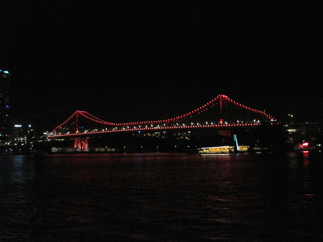
| The eight-lane Auckland Harbour Bridge, which crosses the blue-green waters of Waitematā Harbour, joining St. Mary's Bay in Auckland with Northcote and other North Shore suburbs across the harbour. The 3,348 foot long bridge was built between 1954 and 1959 and opened on 30 May 1959. The bridge has been criticised for attempting to mimic the Sydney Harbour Bridge in Australia, and also for its lack of pedestrian and bicycle access. |
 |
| An Australian pied cormorant, also known as a pied shag or Karuhiruhi in Maori, sits on a rock along Waitematā Harbour. |
 |
| Historic sailing craft tied up outside the New Zealand Maritime Museum on Auckland's Hobson Wharf. The museum houses a variety of exhibits, including ones dedicated to the early Polynesian explorers to New Zealand, the European voyages of discovery, settlement and immigration to New Zealand, whaling and sealing industries, coastal trading, modern commercial shipping, and New Zealand's history of competing in the America's Cup yachting competitions. |
 |
| Luxury yachts and sailboats moored in Viaduct Basin in Auckland's Wynyard Quarter. |
 |
| The Nautilus, a heritage motor launch built in 1913 as a family excursion boat for picnics and outings. During the First World War, Nautilus was donated to the government by its owner, Francis H.E. Chester, and was one of two motor launches carried aboard the New Zealand hospital ship Marama in the Mediterranean. Returned to Mr Chester in January 1918, Nautilus passed through various owners until it was donated to the New Zealand Maritime Museum in 2011 and extensively restored. |
 |
| The historic steam tug William C. Daldy, built in Renfrew, Scotland in 1935 and now maintained by a preservation group and chartered out for functions and cruises. The tug is powered by two coal-fired boilers. In 1958, the Daldy spent 36 uninterrupted hours keeping a tow on a barge carrying a 1,200 ton pre-assembled section of the Auckland Harbour Bridge, then under construction, when a violent storm swept up the Waitematā harbour threatening to overpower the barge and destroy or damage the bridge section; over the course of those 36 hours, the Daldy burned 40 tons of coal. |
 |
| Albert Park in central Auckland. The park is bounded by Wellesley Street East, Bowen Avenue, Princes Street, and Kitchener Street, and was laid out in the 1880s on the former site of the Albert Barracks, an early military fortification in Auckland. |
 |
| A cast iron fountain, imported from England in 1881, forms the focal point of Albert Park, and sits along the north-south axis of the park's layout. |
 |
| A southward view along the main axial pathway through Albert Park. The park contains a number of old specimen trees dating from the 1880s to the First World War, as well as various statues and memorials, a band rotunda, and a caretaker's cottage. |
 |
| Banyan fig trees tower over a pathway in Albert Park. |
 |
| The University of Auckland's iconic Clock Tower building (Old Arts Building) peeks out from behind the trees of Albert Park. |
 |
| A memorial to New Zealanders killed in the Boer War, erected by members of the New Zealand Battery, Royal Artillery. Behind the statue sit two large field guns, originally installed as part of the city's defences during the Russian Invasion Scare of the 1880s. |
 |
| A statue of Sir George Grey, a British explorer, soldier, and writer who twice served as Governor of New Zealand (1845-1853; 1861-1868) and as the 11th Premier of New Zealand (1877-1879). Grey is viewed as the most influential figure during the European settlement of New Zealand during the 19th century. Grey returned to England in 1894 and died in his London home on 19 September 1898 at the age of 86; he is buried in St. Paul's Cathedral. |
 |
| A pleasant duck pond in the Auckland Domain, the city's oldest park, located in the suburb of Grafton. |
 |
| The Auckland Domain's 75 acres feature broad, green lawns and playing fields, formal gardens, natural areas of native vegetation, and a number of walking paths. The Auckland Domain also is home to the Wintergardens and the Auckland War Memorial Museum. The park encompasses the entire explosion crater and most of the tuff ring of the ancient Pukekawa volcano. |
 |
| The central courtyard of the Wintergardens, featuring neoclassical statuary, a sunken lily pond, and pergolas. On either side of the courtyard are two glasshouses, one heated (Tropical House) and one unheated (Temperate House). |
 |
| The exterior of the Temperate House in the Auckland Domain. The Temperate House was completed in 1921 with funds raised from the wildly successful Auckland Industrial, Agricultural, and Mining Exhibition held between December 1913 and April 1914, which attracted 870,000 visitors at a time when Auckland's population was only approximately 100,000 and New Zealand's entire population had only recently surpassed one million. The matching (but heated) Tropical House was completed in 1929, while the adjacent Fernery features many varieties of ferns planted on the site of a former quarry. |
 |
| Geese enjoy the last minutes of sunshine before dusk sets in at the Auckland Domain. |
 |
| Various species of native trees occupy a grassy expanse in the Auckland Domain. |
ROYAL NEW ZEALAND NAVY 75TH ANNIVERSARY INTERNATIONAL NAVAL REVIEW
 |
| One of the sign boards along Auckland's harbourfront advising visitors of the International Naval Review schedule of events and participating warships. |
 |
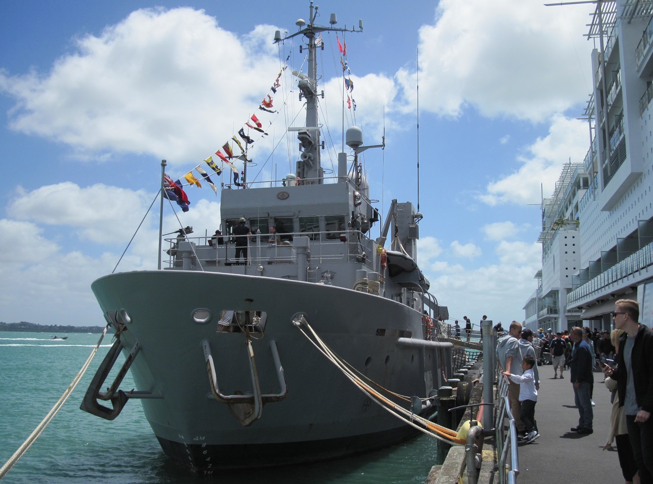
| Locals and visitors in Auckland for the International Naval Review stroll past HMNZS Taupo (P3570), a Protector-class inshore patrol boat commissioned into the Royal New Zealand Navy on 29 May 2009. |
 |
| The Chilean Navy's four-masted, steel-hulled sail training barquentine Esmeralda and the Royal New Zealand Navy's Protector-class inshore patrol boat HMNZS Hawea (P3571), moored at the Captain Cook Wharf. Esmeralda, which was launched on 12 May 1953, was used by the Pinochet regime as a floating jail and torture chamber for political opponents between 1973 and 1980 and the ship's international port calls are often met by protests from human rights activists and Chilean expatriates. |
 |
| The Royal New Zealand Navy's offshore patrol vessel HMNZS Otago (P148), alongside Queen's Wharf in downtown Auckland. Otago was launched in 2006 but not commissioned until 2010 due to construction-related problems and later engine issues. HMNZS Otago is homeported in Port Chalmers, near Dunedin in the South Island of New Zealand, and carries a crew of 45, with capacity for an additional four persons from other government agencies. The ship is armed with one remote-controlled Rafael Typhoon 25mm stabilised naval gun and two .50 calibre machine guns, and also carries one SH-2G Super Seasprite helicopter. |
 |
| Visitors board HMNZS Otago in Auckland Harbour during the 'open house' day on Sunday, 20 November 2016. |
 |
| A starboard quarter view of HMNZS Taupo, moored alongside Queen's Wharf. As an inshore patrol boat, the four boats of the Protector-class are designed for operations within 24 nautical miles (44 km) of the coastline. |
 |
| HMNZS Taupo is 180 feet long, with a 30 foot beam, and a displacement of 340 tons. Powered by two MAN diesel engines giving the boat a top speed of 25 knots (64 km/h), the Protector-class inshore patrol boats have a range of 3,000 nautical miles (5,600 km), and carry a complement of 36. Armament consists of three 12.7mm machine guns. |
 |
| Docked at Princes Wharf in downtown Auckland, the Republic of Singapore Navy's RSS Resolution (208), an Endurance-class landing platform dock ship. At a little over 462 feet long, the five vessels of the Endurance class are the largest ships operated by the Republic of Singapore Navy, displacing 6,500 tons. The Resolution carries landing craft and can accommodate 300-500 troops, as well as 18 tanks, 20 other vehicles, and bulk cargo. The ship's complement is eight officers and 57 other ranks. |
 |
| The Indonesian Banjarmasin-class amphibious transport dock KRI Banda Aceh (593). |
 |
| HMNZS Manawanui (A09), the Royal New Zealand Navy's diving support vessel, originally designed as a North Sea oil rig tender but commissioned into the RNZN in 1988. The 911-tonne ship is equipped with a triple lock recompression chamber, a crane with a 13-tonne lifting capacity, a wet diving bell, and a workshop, and is able to maintain station over a fixed point. Royal New Zealand Navy divers aboard Manawanui train in explosive ordnance disposal and underwater demolitions. |
 |
| The Chinese People's Liberation Army Navy (PLAN) Type 054A multirole frigate Yancheng, constructed by Hudong-Zhonghua Shipbuilding and commissioned on 5 June 2012. The Yancheng is posted to the PLAN's North Sea Fleet, based in the Yellow Sea and headquartered in Qingdao in Shandong Province. The Type 054A frigates, 22 of which are currently in service, displace 4,053 tons, carry a complement of 165, and are armed with vertical launch surface-to-air missiles, anti-ship/land attack cruise missiles, one 76mm dual purpose gun, two close-in weapons systems, torpedo launchers, anti-submarine rocket launchers, and one helicopter. |
 |
| Moored aft of the Chinese frigate at Wynyard Wharf are the Japanese Maritime Self-Defense Force Takanami-class destroyer JS Takanami (DD-110) and the Royal New Zealand Navy's Anzac-class frigate HMNZS Te Mana (F111). |
 |
| The JS Takanami is the lead ship of a five-strong class of guided missile and anti-submarine warfare destroyers of the Japan Maritime Self-Defense Force. The 4,650 ton destroyer was commissioned on 12 March 2003 and carries a complement of 175. Her armament consists of a 127mm naval gun, surface-to-surface missiles, two Phalanx close-in weapons systems, torpedo tubes, Evolved Seasparrow Missiles, anti-submarine rockets, and one anti-submarine helicopter. HMNZS Te Mana was commissioned into the Royal New Zealand Navy on 10 December 1999, and carries a complement of 25 officers and 153 ratings. Her armament comprises one 5-inch naval gun, Evolved Seasparrow Missiles, Phalanx close-in weapon system, torpedo launchers, and one SH-2G Super Seasprite helicopter. |
 |
| Docked at the Devonport Naval Base across the harbour from Auckland is the offshore patrol vessel HMNZS Wellington, sistership to HMNZS Otago. |
 |
| The 41,483 gross ton Hambug Süd container vessel MV Spirit of Shanghai docked at the Port of Auckland on 22 November 2016. The ship was built in 2007 and is registered in Singapore. |
 |
| The 59,516 gross ton, Liberian-flagged vehicles carrier Lake Geneva, docked at the Port of Auckland. The vessel was built in 2015. |
 |
| A tug tows two barges through the wind-whipped waters of Waitematā Harbour, as seen from a ferry crossing from Auckland to the suburb of Devonport. |
DEVONPORT
 |
| The front and reverse sides of a ferry ticket, purchased on 22 November 2016 for a trip between Auckland and Devonport. |
Below: A map and information on Devonport Village, as found in a pamphlet for Fullers ferry service.
 |
| Passengers board a ferry at the Devonport terminal, across the harbour from Auckland. |
 |
| Auckland's skyline as seen from the suburb of Devonport. |
 |
| The entrance to Devonport ferry terminal on Marine Square. |
 |
| The Esplanade Hotel, built in 1903 in the Edwardian style and extensively restored as a boutique Hotel in Devonport Village. The hotel features 17 rooms, all with ensuite bathrooms, a lounge bar, a cafe, and the Esplanade Restaurant. |
 |
| Looking up Victoria Road in the quaint and picturesque Devonport Village. |
 |
| Walking east along the harbourside pathway. On windy days, the occasional wave will break over the wall, splashing pedestrians with salty spray. |
 |
| Pleasant homes on King Edward Parade overlook Waitematā Harbour in Devonport Village. |
 |
| Edwardian era homes and apartments on King Edward Parade. |
 |
| Quaint cottages on King Edward Parade are now residences for wealthy Aucklanders. |
 |
| More restored harbourview cottages at the corner of King Edward Parade and Mays Street in Devonport Village. |
 |
| A home surrounded by lush native vegetation, including cabbage trees, looks out over Waitematā Harbour in Devonport Village. |
 |
| A small boat moored in Waitematā Harbour is buffeted by wind and waves, as seen from King Edward Parade. |
 |
| A monument and garden overlooks Waitematā Harbour in Devonport, at the intersection of King Edward Parade and Church Street. |
 |
| Homes cling to the windswept side of North Head, overlooking the aquamarine waters of the harbour. |
TORPEDO BAY NAVY MUSEUM, DEVONPORT
The original museum of the Royal New Zealand Navy opened in 1974 in a single room of the main administrative building, HMNZS Philomel, at the Devonport Naval Base, and was only open to RNZN personnel for two hours per week. The museum moved to a small building near HMNZS Philomel in 1982, but this also proved too small. On 9 October 2010, the new Torpedo Bay Navy Museum opened in its current location in Devonport, at the end of King Edward Parade, being housed in refitted buildings originally built in 1896 to control naval mines at the mouth of Waitematā Harbour.
 |
| The Torpedo Bay Navy Museum, a free museum dedicated to presenting the history of the Royal New Zealand Navy. |
 |
| A plaque marks the approximate landing site of a boat from the French corvette l'Astrolabe, under the command of Dumont d'Urville, on 26 February 1827. |
 |
| The ensign of the Royal New Zealand Navy flies from a yardarm on the grounds of the Torpedo Bay Navy Museum. |
 |
| An anchor from the German sloop SMS Adler, wrecked at Apia, Samoa in a hurricane on 15 March 1889, along with five other German and American ships. This anchor was recovered by divers from HMS Dunedin on 31 January 1930 and was presented to the naval base by His Excellency S.S. Allen, the Administrator of Western Samoa. |
 |
| The museum's first permanent gallery is dedicated to the First World War Royal Navy battlecruiser HMS New Zealand. |
 |
| The gallery tells the story of HMS New Zealand's participation in all three of the First World War's major naval engagements: the Battle of Heligoland Bight (28 August 1914); the Battle of the Dogger Bank (15 January 1915); and the Battle of Jutland (31 May-1 June 1916). The display cases contain relics and artefacts from the ship and her crew. |
 |
| A scale model of HMS New Zealand. To fund the construction of the battlecruiser, a loan of £2 million was raised, a loan that was only paid off in 1945, 21 years after the ship had been scrapped. |
 |
| Another view of the HMS New Zealand Gallery. |
 |
| A silver bell originally cast in 1905 for the King Edward VII-class battleship HMS New Zealand and later installed in the battlecruiser HMS New Zealand. |
 |
| A 1,064 pound piece of armour plate gouged from HMS New Zealand's 'X' turret by a German shell at the Battle of Jutland. |
 |
| A ceremonial hatchet and silver case. The hatchet was used by Lady Ward, wife of Prime Minister Sir Joseph Ward, to launch the battlecruiser HMS New Zealand on 1 July 1911 at the yard of Fairfield Shipbuilding and Engineering Ltd. in Glasgow, Scotland. |
 |
| A display on the Battle of the River Plate, which occurred between a British squadron (including the New Zealand-manned HMS Achilles) and the German pocket battleship Admiral Graf Spee on 13 December 1939 in the estuary of the River Plate between Argentina and Uruguay. |
 |
| The wooden 'ditty box' of Leading Seaman T.A. Hutchins of HMS Achilles at the Battle of the River Plate in December 1939. With space at a premium, sailors stowed their personal possessions in these ditty boxes. Hutchins' ditty box contains his wedding photos, a bosun's call, a pipe, and dog tags should he be captured or killed. |
 |
| A gallery dedicated to the Battle of the River Plate, in which the Leader-class light cruiser HMS Achilles, manned by New Zealanders, took part. |
 |
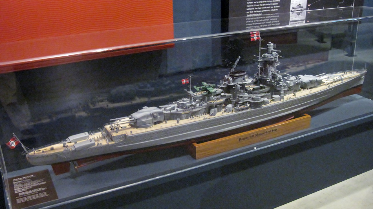
| A scale model of the 14,890 ton German pocket battleship Admiral Graf Spee, badly damaged by British cruisers in the Battle of the River Plate and later scuttled by her crew to avoid the ship's capture. |
 |
| A splinter from an 11-inch shell fired by the German pocket battleship Admiral Graf Spee at the Royal Navy light cruiser HMS Ajax. |
 |
| A 9mm Luger pistol like the one used by Captain Hans Langsdorf (photo) to commit suicide in his hotel room in Buenos Aires following the scuttling of his badly damaged ship in the River Plate estuary on 17 December 1939. |
 |
| A display of naval ordnance fired by the ships during the Battle of the River Plate. The replica shell on the left is a 590-lb, 11-inch round like those fired by German pocket battleship Admiral Graf Spee. The replica shell in the middle is a 225-lb, 8-inch round of the kind fired by heavy cruiser HMS Exeter. The replica shell on the right is a 90-lb, 6-inch round of the type fired by light cruisers HMS Ajax and Achilles. |
 |
| A scale model of the 7,270 ton HMS Leander, a light cruiser of the New Zealand Division of the British Royal Navy. The ship was later transferred to New Zealand and recommissioned as HMNZS Leander in September 1941. |
 |
| A display on HMS/HMNZS Leander's operations during the Second World War, including its sinking of the Italian raider Ramb 1 in the Indian Ocean on 27 February 1941. Leander's captain had suspected that Italian raiders were using a particular sea lane near the Maldive Islands, an intuition that proved correct when he intercepted Ramb 1 on the morning of the 27th. After trying to disguise itself as a British merchantman, Ramb 1 opened fire on Leander, to which Leander responded with its 6-inch guns. Ramb I burned for a time after her crew abandoned ship in lifeboats, and then a series of explosions tore through her. Ramb 1 sank shortly thereafter. |
 |
| A view of the main gallery of the Torpedo Bay Navy Museum. |
 |
| A display on the minesweepers HMNZS Moa, Kiwi, and Tui. Moa and Kiwi, along with senior ship HMNZS Matai formed the 25th Minesweeping Flotilla in the Soloman Islands during the Second World War, where they escorted convoys, conducted anti-submarine patrols, and supported American ground forces during the Solomans campaign. Moa and Kiwi battled and sank the bigger, more heavily-armed Japanese submarine I-1 on the night of 29 January 1943 in the battle of Kamimbo Bay, Guadalcanal. |
 |
| One of the 5.5-inch guns from the Japanese submarine I-1, sunk by HMNZS Moa and Kiwi on the night of 29 January 1943 at Kamimbo Bay, Guadalcanal. |
 |
| A scale model of HMNZS Rotoiti, a Loch-class frigate which served in the Royal Navy as HMS Loch Katrine from December 1944 until decommissioned in May 1946. The ship was sold to the Royal New Zealand Navy in 1948 and recommissioned as HMNZS Rotoiti in May 1949. A busy post-war career included two deployments to the Korean War and support to British nuclear weapons trials at Christmas Island. HMNZS Rotoiti was withdrawn from service in 1966, sold for scrapping in 1967, and broken up in Hong Kong. |
 |
| A gallery of assorted naval artefacts and scale models. |
 |
| A display of copper decanters used to issue the rum ration to sailors when this custom was still practiced aboard Royal New Zealand Navy ships. |
 |
| A binnacle from a Royal New Zealand Navy vessel. |
 |
| A scale model of the 1,275 ton Ailanthus-class netlayer HMNZS Endeavour. Built in the United States in 1944, Endeavour was eventually sold to New Zealand in August 1956 to serve as an Antarctic support vessel, carrying 34 officers and ratings, as well as 18 civilians. Sold to Canadian buyers in 1962, the ship, renamed Arctic Endeavour, served as a sealing vessel but foundered off the Newfoundland coast in November 1982. |
 |
| A display of photos and films of Royal New Zealand Navy personnel over the years. |
 |
| A scale model of the Rothesay-class (Type 12) frigate HMNZS Otago (F111). Displacing 2,110 tons, the 370-foot long Otago carried up to 240 officers and ratings, and was armed with two 4.5-inch guns, one 40mm gun, two Limbo anti-submarine mortars, and torpedo launchers. Two steam turbines could propel the ship at speeds up to 30 knots (56 km/h), with a range of 5,200 nautical miles (9,630 km) at a cruising speed of 12 knots. |
 |
| Part of the gallery dedicated to the Royal New Zealand Navy's post-war operations in support of regional and international peace and security. |
 |
| The A.D. Boyle Room, built into the side of a cliff in 1898 and originally called the Test Room. The room was used between 1898 and 1907 to operate and manage the live submarine mine network used to defend Auckland Harbour. The room now houses a variety of artefacts commemorating the Royal New Zealand Navy's role in the First World War. |
 |
| A mahogany sideboard from the Admiral's dining cabin aboard the battlecruiser HMS New Zealand. After the ship was scrapped, the sideboard was shipped to Wellington, New Zealand and placed in the Members and Spouses Lounge in the Parliament Buildings. When the Parliament Buildings were refurbished in 1992, the sideboard was given to the Royal New Zealand Navy and refurbished by personnel at the Devonport Naval Base. |
 |
| The coat of the Royal Arms from HMS Philomel, which was hung in the Navy Office before being transferred to the Torpedo Bay Navy Museum in 1992. |
 |
| A painting of HMS Philomel in the Mediterranean in 1915, by Colin Wynn. Presented to the Torpedo Bay Navy Museum in 1991. |
 |
| A painting of the battlecruiser HMS New Zealand by Gerald Burn, 1913. This canvas originally hung in New Zealand House in London and was returned to New Zealand in 1998; placed in museum storage, the painting has only been placed on brief public display twice. |
 |
| The museum's boat shed houses a variety of historic small boats used by the Royal New Zealand Navy. |
 |
| Notable boats in the museum's collection include a 32-foot cutter, a 27-foot whaler, a 33-foot sailing gig, and a 14-foot clinker-built sailing dinghy. |
 |
| Waves wash over the lower ends of launching ramps leading down from the boat shed. |
North Head Reserve
North Head is one of the many extinct volcanoes in the Auckland region and was once an island. Active within the last 40,000 years, volcanic eruptions of lava and ash eventually linked the island to the mainland. The volcanic cone of solidified rock formed from hot lava, called scoria, overlies beds of volcanic ash, called tuff, into which tunnels were carved to house the coastal defences that were constructed atop North Head in the later 1800s. The Maori called the volcano Maungauika, named after Uika, an ancestor who lived here approximately 800 years ago, and built the fortification of Takapuna atop the volcano to spot waka canoes returning from fishing or trading expeditions, as well as war parties. Maori lived on Maungauika until 1863. In 1836, a pilot station was established on North Head due to the sweeping views of Waitematā Harbour. A Russian invasion scare in the late 1800s led to the fortification of North Head, along with other sites in the Auckland region, the stationing of a torpedo boat at Devonport, and the laying of a minefield across the harbour entrance. North Head continued to be used by the military throughout the First and Second World Wars, though the gun batteries were never fired in anger and were only used for training and ceremonial events. In 1972, North Head was protected as a heritage reserve when it was included in the Hauraki Gulf Marine Park, managed by the Department of Conservation.
 |
| The entrance to the North Head Reserve / Maungauika, an ancient volcanic cone, site of Auckland's 19th and 20th century coastal artillery defences, and now part of the Hauraki Gulf Marine Park. |
 |
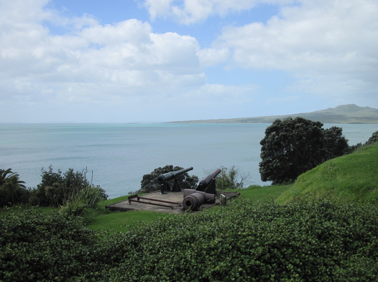
| Historic artillery pieces on display at the North Head Reserve. |
 |
| Displayed on a concrete pad that was formerly the floor of an Army drying room are obsolete guns from the North Head coastal defences. The first guns were placed on North Head in 1870 to defend the harbour defences. The two cut-up sections of barrel are from the 13-ton disappearing gun from the South Battery, scrapped in 1925. This gun fired shells of eight-inch diameter, capable of piercing the armour of ships offshore. The area around this display was used as a practice ground by gunners who trained in moving around heavy artillery pieces using block and tackle, levers, jacks, and brute human strength. |
 |
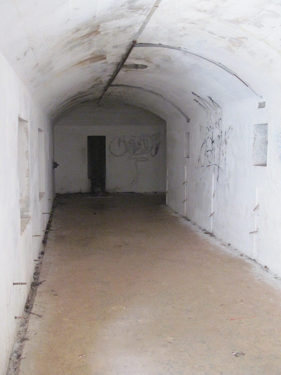
| The entrance to one of the tunnels that linked the various parts of the coastal defence fortifications on North Head. Here, the North Tunnel served North Battery, one of three artillery batteries on North Head in the colonial era. |
 |
| A diagram of the subterranean fortifications of the North Battery, including ammunition storage rooms and accommodations for military personnel. One of three artillery batteries on North Head, North Battery covered the Rangitoto Channel, with construction of the tunnels commencing in 1885 in response to an expanding Russian Empire and the fear of a Russian invasion of New Zealand. |
 |
| Inside the tunnels of North Battery. |
 |
| The ammunition magazine for the 7-inch rifled muzzle loaded guns of the North Battery, constructed between 1885 and 1892. The 7-inch muzzle loaders were the main armament between 1870 and 1888, subsequently being replaced by 8-inch disappearing guns (1888-1920) and a pair of 4-inch guns (1939-1941). After the Second World War, the tunnels and magazines of North Battery were used as a mushroom farm for a while. |
 |
| A view of the Hauraki Gulf from the northern slope of North Head Reserve. |
 |
| Looking northwest, with Cheltenham Beach stretching out below. |
 |
| An observation post. |
 |
| The observation post overlooks the Hauraki Gulf and permitted gunners to sight any enemy ships that may have approached Auckland Harbour. |
 |
| Lush vegetation and spectacular views from the slopes of North Head Reserve. |
 |
| Rangitoto Island in the Hauraki Gulf, as seen from the slopes around North Battery. |
 |
| A sailboat glides through the aquamarine waters of the Hauraki Gulf. |
 |
| Holes in the rock face lead into a cave area near the entrance to South Battery. |
 |
| A diagram of South Battery, which housed one of the state of the art 8-inch disappearing guns that were installed here in 1887. South Battery covered Waitematā Harbour. |
 |
| The entrance to the South Battery tunnels. |
 |
| A look inside the cave area that was part of the South Battery tunnels. |
 |
| The main access tunnel at South Battery. Narrow lamp passages ran around the outside of the ammunition magazines, with candles placed in small recesses covered by a pane of glass; this allowed the magazines to be illuminated without having an open flame, which would have represented an extreme fire risk, given the hundreds of kilograms of gunpowder stored in the magazines. |
 |
| South Battery's 8-inch disappearing gun, overlooking Waitematā Harbour, installed in 1887. In an era when gunnery was based on visual sighting, the disappearing gun reduced the risk of being targeted by ships offshore by lowering into its gun pit after each shot. The gunners would then reload the gun in the protection of the pit and the gun would be hydraulically raised to fire again. Whilst a clever design, these guns suffered from a very slow rate of fire, and all three of North Head's disappearing guns were sold for scrap by the 1920s, though only one gun was actually removed and cut up. |
 |
| First World War era 18-pound field guns installed at South Battery as saluting guns. These guns were last fired to welcome Queen Elizabeth II during a visit in 1953. |
 |
| Waitematā Harbour, with Auckland in the distance, as seen from the summit of the North Head Reserve. |
 |
| One of the pits for an 8-inch disappearing gun. |
 |
| One of the oldest buildings on North Head is the barracks, built in 1885 by the Armed Constabulary, the forerunner of the New Zealand Army. In 1914, the building was used to house up to 40 prisoners, who constructed the fortifications. The building continued in use by the Royal New Zealand Navy and the New Zealand Army until 1996. |
 |
| The stone kitchen, located next to the barracks building, was built in 1885. The kitchen was built out of stone and was separate from the barracks building to limit the risk of fire caused by errant sparks from the timber or coal used to cook food. In the 1800s, each man posted to the North Head fortifications received, on a daily basis, 1.5 pounds of meat, 1.25 pounds of bread or 1 pound of biscuit, 1 pound of potatoes, and 5 ounces of groceries. To cook these rations, the men were each issued 2 pounds of wood or 1 pound of coal. |
 |
| A view of the buildings at the summit of North Head Reserve: the 1885 barracks, the stone kitchen, and newer barracks dating from the Second World War. |
 |
| A diagram of the 6-inch Mk VII gun battery that was built here between 1908 and 1911 at the behest of the British government, which wanted to defend the approaches to the Devonport Naval Base. The 6-inch guns positioned here during the First World War and until 1941 were built by Elswick Ordnance Company in the United Kingdom, weighed 7.4 tonnes each and fired shells out to a range of 11 kilometres; the guns were later moved to Whangaparoa. After the end of the Second World War, the guns were returned to North Head and were used to train conscripts until being scrapped in 1959. |
 |
| Stairs lead down to a complex of subterranean rooms that housed shells, powder bags, and gunners on watch. |
 |
| One of the underground rooms used to store shells or powder for the 6-inch Mk VII guns. |
 |
| The entrance to the engine room, which housed generators used to power the network of searchlights mounted on North Head. The engine room was sited on the side of North Head, out of sight of any enemy ship. The original 25-horsepower coal-fired steam engine was later replaced by kerosene and diesel generators. Electrical cables running through the subterranean tunnels and down the cliff faces fed power to the searchlights. Rooms adjacent to the engine room housed the engine crew, workshops, and the fuel supply. |
 |
| The minefield control post from where military personnel surveyed the minefield laid between North Head and Bastion Point between 1892 and 1908. If an enemy vessel had entered the minefield, the defenders would have detonated the minefield at a time calculated to cause the most damage to the enemy. |
 |
| A stairwell descends into a tunnel leading to the South Battery searchlight complex on the lower slopes of North Head. An original shaft with a ladder was replaced by a sloping tunnel in 1900. With the dismantlement of the minefield in 1907, the searchlight complex was abandonment. |
 |
| The sloping tunnel leading to the searchlight complex. |
 |
| A staircase cut into the rock face leads down nearly to the water. |
 |
| One of the South Battery searchlight positions. The lower footpath hugs the side of North Head as it winds its way around the base of the volcanic cone. |
 |
| The footpath continues along the edge of the cliff face, with the waters of Waitematā Harbour on one side and lush vegetation on the other. |
 |
| A staircase cut into the rock face leads up to the South Battery. |
 |
| A receding tide reveals the rocky shoreline around the perimeter of North Head. |
 |
| Black volcanic rocks along the shoreline, with Rangitoto Island seen in the distance. |
The Fleet Returns
With a number of foreign naval vessels in New Zealand waters for the International Naval Review to celebrate the Royal New Zealand Navy's 75th anniversary, a flotilla was dispatched to the South Island to render assistance to victims of the earthquake which hit near the town of Kaikoura on 14 November. After a busy several days spent helicoptering relief supplies to the town cut off by landslides and sending naval landing parties ashore to check on residents, deliver chemical toilets, and distribute food and water, the ships returned to Auckland on the afternoon of 22 November for some much-deserved shore leave.
 |
| The Anzac-class frigate HMNZS Te Kaha (F77) leads the flotilla into Waitematā Harbour. |
 |
| For the first time in 33 years, a United States Navy vessel enters New Zealand waters: the Arleigh Burke-class destroyer USS Sampson (DDG-102) follows HMNZS Te Kaha. After the New Zealand government of Prime Minister David Lange declared the country a nuclear-free zone in 1984, banning nuclear-armed or nuclear-powered vessels from entering its ports, the United States government suspended its obligations to New Zealand under the Australia-New Zealand-United States (ANZUS) Treaty. Because U.S. government policy was to refuse to confirm or deny the existence of nuclear weapons on its ships, the effect was to deny New Zealand ports to U.S. Navy vessels. The New Zealand government of Prime Minister John Key invited the United States Navy to send a vessel to the RNZN 75th anniversary celebrations in November 2016, and Key personally approved the American vessel's entry into New Zealand waters. |
 |
| Following behind the USS Sampson is the Royal Canadian Navy Halifax-class frigate HMCS Vancouver (FFH331). The recently modernised frigate was the second of 12 Halifax-class ships built by Canada, being commissioned on 23 August 1993. With a complement of 225 (including helicopter detachment), a top speed of 30 knots (56 km/h), and a range of 9,500 nautical miles (17,600 km), the 440-foot long HMCS Vancouver sports a 57mm naval gun, Mk 46 torpedoes, Evolved Seasparrow surface-to-air missiles, Harpoon surface-to-surface missiles, a Vulcan Phalanx close-in weapon system, and six .50 calibre machine guns. The ship also carries one CH-124 Sea King maritime helicopter. |
 |
| HMNZS Te Kaha secures alongside one of the jetties of Devonport Naval Base. |
 |
| HMCS Vancouver is assisted to the jetty by a tugboat. |
 |
| Royal New Zealand Navy dockyard personnel help HMCS Vancouver tie up alongside the jetty at Devonport Naval Base, 22 November 2016. |
 |
| A closer view of HMNZS Te Kaha, secured to the jetty at Devonport Naval Base. The ship's Phalanx close-in weapon system is visible at the top right of the photo, as is one of the distinctive angled exhaust funnels amidships, with the RNZN's kiwi bird logo. |
 |
| HMCS Vancouver firmly tied up. |
 |
| Two Pacific Forum-class patrol boats. Twenty-two such boats were constructed by Australia between 1985 and 1997 and donated to 12 South Pacific nations under the capacity-building Pacific Patrol Boat Program. The boat on the right (04) is Nafanua, operated by the police of Samoa, and was provided to the Samoan government in March 1988. |
 |
| The Canadian flag is raised on HMCS Vancouver's bow jackstaff. |
 |
| Two of the Royal New Zealand Navy's Protector-class inshore patrol vessels: HMNZS Rotoiti (P3569) and HMNZS Pukaki (P3568). The vessels, which were commissioned on 17 April and 14 May 2009, respectively, are moored in front of the ship repair facility operated by Babcock on the grounds of Devonport Naval Base. |
 |
| The Royal Australian Navy Adelaide-class guided missile frigate HMAS Darwin. Built by Todd Pacific Shipyards in Seattle, Washington, Darwin is one of six Adelaide-class frigates ordered by Australia, and was commissioned on 21 July 1984; she is the oldest of the three Adelaide-class frigates still in service. Measuring 453 feet long, HMAS Darwin carries a crew of 184, plus aircrew for two helicopters, and sports Harpoon and Standard missiles, Evolved Seasparrow missiles, Mk 32 torpedoes, a 76mm naval gun, a Phalanx close-in weapon system, and .50 calibre machine guns. |
 |
| The Royal New Zealand Navy Protector-class inshore patrol vessel HMNZS Hawea, now docked at Devonport Naval Base after its participation in the International Naval Review. |
 |
| A historic site: a U.S Navy ship docked in New Zealand for the first time in more than three decades. The skyline of Auckland can be seen behind USS Sampson. |
 |
| On display at the entrance to the Devonport Naval Base is a 6-inch gun turret from HMNZS Achilles, the New Zealand-manned light cruiser that, in company with HMS Exeter and Ajax, engaged the German pocket battleship Admiral Graf Spee in the Battle of the River Plate on 13 December 1939. A plaque notes that the turret was donated to New Zealand by the Indian government, and officially unveiled on 10 May 1980 by the New Zealand Prime Minister, the Rt. Hon. Sir Robert Muldoon. (HMNZS Achilles had been returned to Britain in September 1946 and was subsequently sold to the Indian Navy in 1948, where it was recommissioned as INS Delhi; the ship continued in Indian Navy service until being decommissioned for scrapping on 30 June 1978.) |
 |
| Another view of USS Sampson docked at Devonport Naval Base on 22 November 2016. The Royal New Zealand Navy Anzac-class frigate HMNZS Te Mana is moored outboard of the U.S. destroyer to provide added protection against threats, such as small boat attacks. |
 |
| A port side view of HMAS Darwin, docked at Devonport Naval Base, as seen from an Auckland Harbour ferry. |
 |
| The retail concourse at Auckland International Airport on the morning of 23 November 2016. |
 |
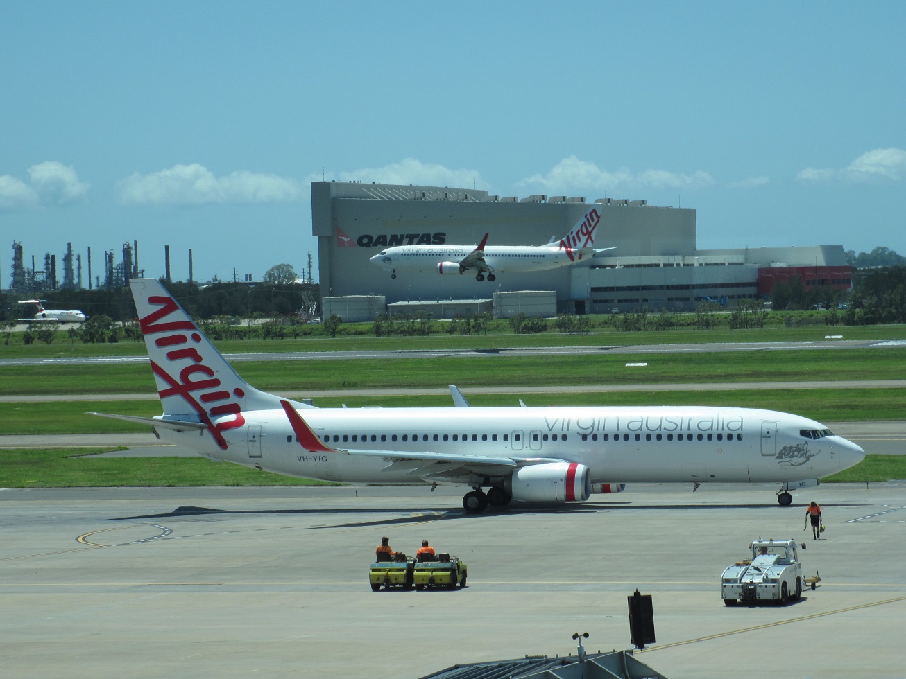
| A Qantas 737-800 is pushed back from the gate, whilst Air New Zealand Airbuses and a Virgin Australia 737 remain parked on the apron. |
 |
| Cafes, restaurants, and shops in the Departures section of the Auckland International Airport. |
 |
| A Qantas 737-800 and an Air New Zealand 777-200ER. |
 |
| Air New Zealand A320-200 (ZK-OJK) at Gate 15. This aircraft first flew on 4 May 2005 and, although bought by Air New Zealand, was leased to New Zealand carrier Freedom Air and then Brazil-based TAM before returning to Air New Zealand service on 3 May 2012. |
 |
| At Gate 15, waiting to board Qantas flight QF144 to Canberra, Australia. |
Canberra (via Sydney), 23-25 November 2016
 |
| First view of Australian soil, as seen from the window of the Qantas 737-800 flying from Auckland to Sydney. |
 |
| Port Hacking, as seen from Qantas flight QF144 en route to a landing at Sydney's Kingsford Smith International Airport. The villages of Bundeena and Cronulla, on the outskirts of southern Sydney, can be seen on the left and right sides of the bay, respectively. |
 |
| A 737-800 waits on the taxiway as QF144 lands on Runway 34L at Kingsford Smith International Airport in Sydney. |
 |
| International flavour parked at Sydney: A Thai Airways 747-400, a British Airways 777-300, a Singapore Airlines A380, and long-haul aircraft from Etihad Airlines and United Airlines. |
 |
| An Emirates Airlines Airbus A380. This aircraft, registration A6-EOL, first flew on 3 March 2015. |
 |
| A QantasLink Bombardier Q400 turboprop at the Domestic Terminal prior to boarding passengers for flight QF1419 to Canberra. |
 |
| Rydges Capital Hill Canberra Hotel, located on Canberra Avenue between Dominion Circuit and National Circuit. |
 |
| The main entrance to the hotel. |
 |
| The expansive lobby, looking towards the main entrance. A florist shop is located to the right of the door. |
 |
| A large, open lobby leads to the garden atrium, as well as to a lounge and bar. |
 |
| The lounge area, located off the lobby. |
 |
| A pool table in the Capital & Co Bar. |
 |
| The Capital & Co Bar offers specialty cocktails, beer, and wine, and features comfortable seating, as well as a heated outdoor terrace. |
 |
| The centrepiece of the hotel is its garden atrium, a magnificent indoor oasis of trees and plants covered by a large canvas awning. The atrium hosts the hotel's Figtree Restaurant, which serves a full, hot buffet breakfast seven days a week, and is also open for dinner. |
 |
| Mature trees and lush vegetation in large planters bring the outdoors inside. |
 |
| Diners at the Figtree Restaurant are seated at tables tucked into cozy nooks underneath towering palms and eucalyptus trees in the atrium. |
 |
| The hotel's interior rooms look out into the garden atrium, which rises the full height of the hotel. |
 |
| The hotel features generous public spaces, such as this curved staircase leading down to the lobby. |
 |
| A comfortable 2nd floor sitting area overlooking the garden atrium. |
 |
| A catwalk leads around the perimeter of the atrium on the 3rd floor. |
 |
| The solarium, accommodating part of the Figtree Restaurant. |
 |
| Looking down on the Fig Tree Restaurant from the 2nd floor catwalk. |
 |
| The Figtree Restaurant's buffet. |
 |
| One of the hotel's conference rooms, arranged for an upcoming corporate event. |
 |
| The gently curving corridor leads to Suite 378. |
 |
| Suite 378. |
 |
| The front and reverse sides of the electronic keycard for Suite 378. |
 |
| The suite features a large living room, with couches and a flat screen television, as well as floor-to-ceiling windows. |
 |
| A full kitchen provides a stovetop, microwave oven, sink, and mini-fridge, as well as a full complement of utensils, pots, pans, and dishes. |
 |
| A cardboard coaster from Suite 378 of Rydges Capital Hill Canberra. |
 |
| A dining set, with a view down the corridor to the master bedroom. |
 |
| An incredibly spacious master bedroom with King size bed. |
 |
| The master bedroom features a flat screen television, writing desk, ample cupboard space, and floor-to-ceiling windows. |
 |
| A notepad from Suite 378 of Rydges Capital Hill Canberra. |
 |
| A second bedroom features two single beds. |
 |
| One of two full bathrooms in Suite 378, featuring upgraded fixtures, tiling, and mirrors. |
 |
| St. Andrews Presbyterian Church, near State Circuit and Canberra Avenue. The foundation stone of the church was laid by His Excellency the Governor-General, the Viscount Stonehaven, on 27 November 1929. The Great Depression prevented the construction of half of the planned church: only the apse, transept, tower, and spire were completed. On 22 September 1934, the church was officially opened by His Excellency the Governor-General, the Right Honourable Sir Isaac Isaacs. |
 |
| One Canberra Avenue, housing offices of the Department of Finance and the Department of Human Services. |
 |
| The Australian flag flies from the 266-foot flagpole atop Parliament House, which opened on 9 May 1988 and cost $1 billion (Australian). |
 |
| The main foyer of Parliament House. Doors open into the Great Hall, a large room used for events, including Canberra University graduations and weddings. |
 |
| Marble staircases lead to the upper level. |
 |
| The Members' Hall in Parliament House. |
 |
| An outdoor terrace overlooks the plaza in front of the main entrance. |
 |
| A statue of Queen Elizabeth II, who opened Parliament House in 1988, by sculptor John Dowie. |
 |
| The interior of the Queen’s Terrace Café, serving beverages and light meals. |
 |
| Franklin Street in the Manuka neighbourhood of the Inner South district of Canberra. Shops and restaurants with patio seating lend a small town feel to Manuka. |
 |
| Retail concourse at Canberra Airport. |
 |
| Departure lounge at Canberra Airport. |
 |
| A QantasLink Boeing 717 at Canberra Airport. This aircraft (registration VH-YQS) was built in January 2004 at Long Beach, California for Midwest Airlines; in 2013, the aircraft was sold to Qantas and entered revenue service on 19 November 2013. |
 |
| Qantas 737-800, registration VH-VXE, which entered service on 19 February 2002. This aircraft, named Coffs Harbour, was preparing to fly to Brisbane on 25 November 2016. |
Brisbane, 25-30 November 2016
 |
| Brisbane, as seen from the lookout on top of Mount Coot-tha. |
 |
| The recently-completed Ibis Styles Brisbane Elizabeth Street hotel, located near the corner of Elizabeth and George Streets in the Brisbane Central Business District (CBD). |
 |
| Corridor on the 18th floor of the Ibis Styles Brisbane Elizabeth Street hotel. |
 |
| The front and reverse sides of the electronic keycard for Room 1810. |
 |
| Room 1810, a small but colourful, clean, and well-appointed room for the next five nights. |
 |
| A stunning view of the Brisbane River from the windows of Room 1810. The room features a Queen size bed, mini-fridge, iron and ironing board, safe, tea/coffee service with kettle, a flat screen television, headboard-mounted reading lamps, and free WiFi. |
 |
| A notepad from Room 1810 of the Ibis Styles Brisbane Elizabeth Street hotel. |
 |
| Looking down at the Treasury Casino building located on George Street below. |
 |
| Looking down at the intersection of George and Elizabeth Streets. The grassy plaza is Queen's Gardens, with palm-lined pathways leading up to the Treasury Hotel, formerly the Executive Building, built between 1901 and 1905. Before being converted into a hotel as part of the Treasury Hotel and Casino complex, the Executive Building housed the Lands and Survey Departments, the offices of the Premier of Queensland and the Queensland Executive Council, and the Queensland National Art Gallery. |
 |
| A view of the Wheel of Brisbane, the nearly 60 metre tall ferris wheel manufactured by Swiss company Bussink and erected in Brisbane in August 2008 to mark the 20th anniversary of World Expo 88 and the 150th anniversary of founding of Queensland. |
 |
| The well-appointed washroom in Room 1810. |
 |
| Bars of soap provided to guests of the Ibis Styles Brisbane Elizabeth Street hotel. |
 |
| A walk-in shower with glass door and partition. |
 |
| The front and reverse sides of a note slipped under the door after having left the Do Not Disturb sign on the room door all day whilst out sightseeing. |
Historic Brisbane
 |
| Located between William Street and the bank of the Brisbane River is the Commissariat Store, the second oldest building in Queensland (built in 1829), and one of two surviving buildings constructed during Queensland's convict period. Convict labourers under the supervision of the settlement's commandant, Captain Logan, built the original two-storey Commissariat Store from stone quarried from the nearby Kangaroo Point and Oxley Creek. The building was used to store and distribute goods and rations, such as food, clothing, and tools, to the population of the Moreton Bay Penal Settlement. After new convict admissions were stopped in 1839 and Brisbane was declared open for free settlement in 1842, the Commissariat Store continued to be used as a goods store, as well as an immigration barracks and as a police barracks. In 1913, a third storey was completed. The building was damaged and temporarily closed for repairs following the January 2011 Brisbane floods. The Commissariat Store has been occupied by the Royal Historical Society of Queensland since July 1977, and operates a museum, library, and event space. |
 |
| The Regent Theatre, built in 1929 to show the Hollywood films that were increasingly popular in the 1920s. The Regent contained 2,500 seats, a stage and movie screen, air-conditioning, ornate chandeliers, carpets woven in Belgium, and a Wurlitzer organ imported from the United States that could be raised and lowered on a hydraulic platform. In the late 1970s, the single large theatre was replaced by four smaller cinemas. These were subsequently demolished, though the façade and grand staircase have been preserved. The Regent Theatre now serves as the Brisbane Visitor Information and Booking Centre. |
 |
| The Brisbane Arcade, built in 1924, is the city's oldest surviving shopping arcade. The Brisbane Arcade was built by a local philanthropist and his sister at a cost of £70,000, and featured shops mostly geared towards women, including dressmakers, hat shops, cobblers, a florist, a silk specialist, an umbrella maker, and several cafes. Today, the Brisbane Arcade houses various upscale retailers. |
 |
| The Albert Street Uniting Church at the corner of Albert and Ann Streets, opened on 8 November 1889 and was originally called the Albert Street Methodist Church. The Albert Street Uniting Church was designed by notable Brisbane architect G.H.M. Addison, who also designed a number of other surviving colonial-era buildings in the city. In 1977, the Methodist, Presbyterian, and Congregationalist churches amalgamated into the Uniting Church of Australia. |
 |
| The Ann Street Presbyterian Church, originally built in 1858 and destroyed by fire in 1871. Rebuilt in 1872, the church is still home to a Presbyterian congregation that traces its roots to the 1849 arrival in Brisbane of three ships carrying 256 mainly Presbyterian immigrants who had been promised land grants by the city's Presbyterian minister, Reverend Dr John Dunsmore Lang. After the government denied knowledge of Lang's promised land agreement, the immigrants were forced to establish a temporary tent city. |
 |
| The Servants' Home, completed in 1866 to house young, single women who were believed to be at risk from the undesirable elements of what was then a rough, frontier town populated by a large number of dockworkers, brothel owners, tavern keepers, and criminals. For a small fee, girls of good character and denomination received accommodation and training in preparation for jobs as domestic servants. In 1878, the Servants' Home was renamed the Brisbane School of Arts. |
 |
| A step set of steps, called Jacob's Ladder, at the intersection of Edward and Turbot Streets. The steps lead up through the edge of King Edward Park to Wickham Terrace. |
 |
| Craigston, a historic apartment block at 217 Wickham Terrace, built in 1927. The eight-storey building was Brisbane's first multi-storey apartment block, conceived of as a combination office/residential tower, with medical offices on the ground floor and apartments on the upper floors. The Spanish Mission-style design features a terracotta tiled roof, arched entry and windows, and a decorative parapet at the penthouse level. |
 |
| The Metro Hotel Tower Mill, formerly the Tower Mill Motel, opened in 1966 and one of Brisbane's most innovative buildings. The hotel was the site of anti-Apartheid protests in July 1971, when the South African Rugby Union team, the Springboks, were staying at the hotel. Queensland Premier Joh Bjelke-Petersen had declared a State of Emergency eight days previously and, when the protesters began chanting 'Springboks go home', police rushed and beat the protesters. A similar violent clash was repeated during another protest held after the rugby match in the vicinity of the hotel. |
 |
| The Windmill Tower, the oldest building in Queensland, constructed in 1828 by convicts of the Moreton Bay Penal Settlement. Originally built to grind wheat and grain for the settlement, the windmill's sails failed to work and a treadmill was subsequently constructed on the side of the mill and operated by convicts as a form of punishment. Following the closure of the penal settlement in 1839, the Windmill Tower went unused until it was converted into a telegraph signal station in 1861. The Queensland Institute of Radio Engineers leased the tower in the 1920s and, in 1934, Queensland's first television signal was broadcast from here. |
 |
| The 'Green House', built in 1906-1907. As Brisbane's medical precinct, Wickham Terrace was home to many of the city's doctors and the Green House's first owner was Dr Thomas Morgan, who both lived and practiced in the house. Today, the Green House is part of the United Service Club. |
 |
| The Baptist City Tabernacle, the second Baptist church built in Brisbane in the late 1880s and dedicated on 9 October 1890. The Baptist City Tabernacle offered its basement to the Queensland Government as an emergency centre in the event of air raids, as well as served the needs of Baptists in the United States Army who were stationed in the city during the war. |
 |
| The former 'People's Palace' at the intersection of Ann and Edward Streets, opened on 27 June 1911 by the Salvation Army as an affordable temperance hotel. Gambling and drinking were banned in the hotel, which was situated across the street from the Temperance Hall operated by the Brisbane Total Abstinence Society. Today, the building is the home of Nomads Hostel Brisbane. |
 |
| Central Railway Station, located on Ann Street, was built in 1889. A larger, more impressive terminal building replaced the original terminal in 1899. Central Railway Station was the first in Australia to utilise electro-pneumatic signalling to raise and lower signals and levers. Regrettably, much of the 1899 terminal was demolished in the early 1970s in order to construct a high-rise administrative building over the platforms. In 1984, the construction of the Sheraton Hotel over the station building further affected the appearance of the station, leaving the Ann Street frontage as the only remaining component of the original terminal building. |
 |
| Today, Central Railway Station is the principal station on the City network of Queensland Rail's North Coast line. Trains operating out of Central Railway Station service the Beenleigh, Gold Coast, Cleveland, Ferny Grove, Airport, Sunshine Coast, Doomben, Shorncliffe, Exhibition, Ipswich and Rosewood, Springfield, and Caboolture lines. A major upgrade to the station is scheduled to commence in early 2017. |
 |
| A view of the platforms of Brisbane's Central Railway Station. The station features three islands with six tracks. |
 |
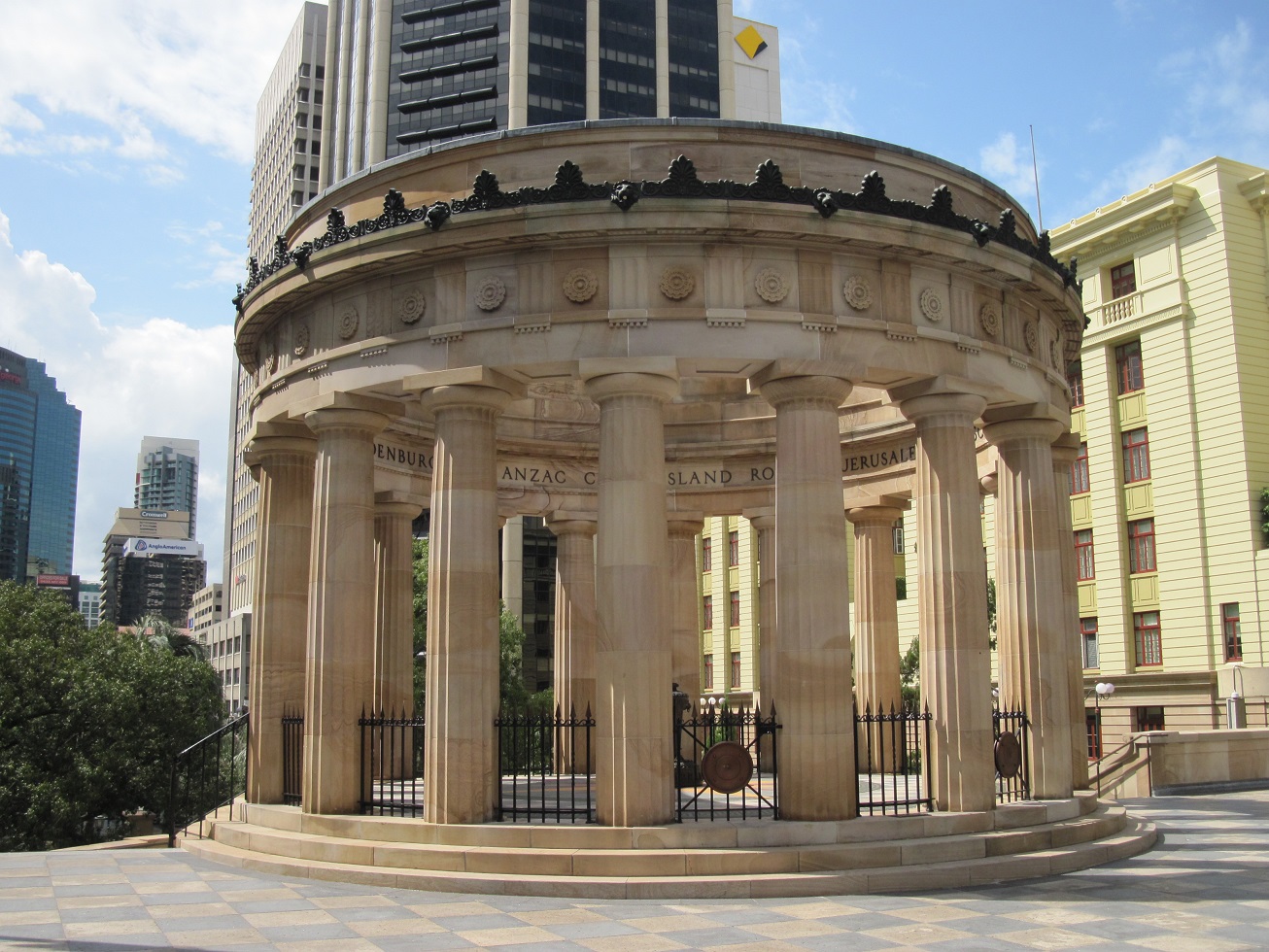
| The Shrine of Remembrance, a memorial to the fallen soldiers of the Australian and New Zealand Army Corps (ANZAC) of the First World War. Designed in the Greek Classic Revival style, this war memorial is located in ANZAC Square, across the street from Central Railway Station on Ann Street. ANZAC Square extends the width of the city block between Ann and Adelaide Streets. |
 |
| The brass urn containing the 'Eternal Flame' at the centre of the Shrine of Remembrance in ANZAC Square. The names of famous ANZAC battles are carved around the inside top of the memorial, which took two years to construct and was dedicated on 11 November 1930. Every year, commemorations are held at the Shrine on 25 April to mark ANZAC Day and 11 November to mark the end of the First World War. Australia suffered 60,000 dead and 152,000 wounded in the First World War. |
 |
| An impressive staircase leads up from ANZAC Square to the Shrine of Remembrance. The steps are carved from Queensland granite, and the eighteen columns of the memorial are Helidon sandstone. A plaque on the memorial reads: 'For God, King & Empire: to the men and women who by patriotism and sacrifice served their country during the Great Wars 1914-1918 - 1939-1945 and in hallowed memory of those who made the supreme sacrifice, this monument is erected by the people of Queensland.' |
 |
| An equestrian statue dedicated to those Queenslanders who died in the Boer War, 1899-1902. The statue overlooks Adelaide Street, at the southern end of ANZAC Square. |
 |
| An ANZAC Square sculpture dedicated to those who served in the South West Pacific Campaign, 1942-1945. The sculpture depicts a wounded Australian soldier descending from the Kokoda Trail, assisted by a Papua New Guinean, whilst a fresh soldier passes them on the way to the battlefield ahead. |
 |
| An ANZAC Square sculpture commemorating Australia's participation in the Vietnam War, 1962-1973. |
 |
| An ANZAC Square sculpture dedicated to those Australians and their allies who served and died in operations in Korea, Malaya, and Borneo, 1948-1966. |
 |
| Baobab trees line the pathway from Adelaide Street to the steps of the Shrine of Remembrance in ANZAC Square. The trees commemorate the Queensland Light Horse regiments which fought in the Boer War, 1899-1902. |
 |
| A view of ANZAC Square and the Shrine of Remembrance, as seen from the Adelaide Street end of the park. Central Railway Station can be seen on Ann Street, behind the Shrine. |
 |
| Located in Post Office Square, across the road from ANZAC Square, is a statue of Major-General The Honourable Sir William Glasgow, KCB, CMG, DSO, VD, Croix de Guerre, 1876-1955. Glasgow served in the Boer War and in the Gallipoli and French theatres of the First World War before being elected to the Federal Parliament and serving as Minister for Home Affairs and Defence between 1920 and 1932. He later served as Australia's High Commissioner to Canada from 1940 to 1945. This bronze statue on a granite plinth was unveiled at a different location on 11 November 1966, subsequently being relocated to another city park in 1968, and to its present location in Post Office Square in 2008. |
 |
| Post Office Square extends the width of the city block between Adelaide Street in the north and Queen Street in the south. Opened in 1984, the 3,300 square metre Post Office Square is elevated from street level, with a shopping concourse and six-storey car park located underneath. The General Post Office building on Queen Street can be seen facing the square in this photo. |
 |
| The General Post Office building, originally opened on 28 September 1872 and extended in 1908. Still used as a post office by Australia Post, the General Post Office building was constructed on the site of the Female Factory barracks for women convicts, demolished in 1871. The central tower, southern telegraph wing, and a clock were added in 1879, and in 1880 Brisbane's first telephone exchange was installed here. The building was the site of the first use of a typewriter in any post office in Australia in 1892. |
 |
| The former Colonial Mutual Life Building, located on Queen Street, next to the General Post Office. Built in 1930-1931, this 10-storey Art Deco-style building was built for the Colonial Mutual Life Assurance Society and is faced in Benedict stone, a multi-coloured artificial stone made from crushed volcanic rock and concrete. The exterior features ornate gargoyles, lions, relief blocks, and shields. In 1994, the building was refurbished and converted to an apartment hotel, the Manor Apartment Hotel. |
 |
| St. Stephen's Chapel, a Catholic church located on Elizabeth Street. The first service to be held at St. Stephen's was on 12 May 1850. It is believed that St. Stephen's was designed by Augustus Pugin, a noted British architect responsible for the Elizabeth Tower (home of the Big Ben bell) at London's Palace of Westminster. St. Stephen's Cathedral was built next to the church in 1874, at which point the church became a school run by the Christian Brothers. |
 |
Looking east along Adelaide Street.
|
 |
| Parliament House, the home of the Queensland Legislative Assembly, located at the corner of George and Alice Streets. With the abolition of the Legislative Council (upper house) in 1922, Queensland became the only state in Australia to have a unicameral parliament (all others have both lower and upper houses). Construction of the building, designed in the French Renaissance style by Queensland Colonial Architect Charles Tiffin, began in 1865, and the first wing was completed in 1867. Additional wings were completed 1868, 1878, and 1889. With a need for additional office space, the Parliamentary Annexe was designed in the brutalist style and completed in 1979. |
 |
| Free 30-minute public tours are available every weekday, though photography inside is strictly controlled for security reasons. The only interior part that visitors are allowed to photograph is the ceremonial staircase, with its ornately-carved banisters, antique stained glass windows, and inlaid wood floor tiles. |
 |
| The Mansions, located at the corner of George and Margaret Streets. This row of six Queen Anne-style townhouses were completed in 1889 to a design by English architect George Addison. The three-storey townhouses were built as an investment by three Queensland politicians and were rented by professionals, including Dr Lilian Violet Cooper, who set up her practice in The Mansions in 1891. |
 |
| Between 1896 and 1954, The Mansions were subdivided into boarding houses, being named Lonsdale, Glemore and Binna Burra in 1947. The Queensland government purchased the building in 1954 and converted it to office space for the Statistician's Office, Medical Boards, Licensing Commission, Prices Branch, Department of Public Works, and the Probation Office. Slated for demolition in 1974 as part of the Queensland government's George Street Master Plan, The Mansions were saved after the adoption of a new plan which recommended the demolition of only the servants' wings and stables. Extensively restored in the 1980s, The Mansions today once again house professional offices , as well as a restaurant, Augustines on George. |
 |
| The heritage-listed Queensland Club, located at the corner of Alice and George Streets, across from the City Botanic Gardens. The three-storey building was constructed between 1882 and 1888 as a private club for notable men, such as politicians, professionals, businessmen, and wealthy farmers. Originally, the building contained 41 members' bedrooms, eight bathrooms, a club room, dining room, billiards room, smoking room, visitors' room, office, and kitchens and servants' quarters. |
Old Government House
Below: The front and reverse sides of the guide available to visitors to Old Government House.
 |
| Old Government House in Brisbane's Gardens Point area, inside the grounds of the Queensland University of Technology and near the City Botanic Gardens. Completed in 1862 as a residence for the first Governor of Queensland, Old Government House was the first significant architectural work undertaken by the newly-formed colony, following Queensland's independence from New South Wales in 1859. |
 |
| The two-storey Classical revival-style house was designed by Queensland Colonial Architect Charles Tiffin using local materials, such as sandstone and Brisbane tuff (volcanically-formed stone), red cedar, hoop pine, and cast iron. Notably, a grand design with lots of ornate decoration was deliberately rejected so as to avoid offending politicians and country citizens. Tiffin's design placed the Governor's public rooms and private residence in the front half of the house and service areas and servants' rooms in the rear half of the house. |
 |
| The ground floor drawing room of Old Government House. Queensland's first Governor, Sir George Bowen, and his family moved into Old Government House in April 1862 and the house served as the residence for 10 subsequent governors, with minor modifications undertaken over the years. In December 1909, with the house nearly 50 years old and considered inadequate to needs, it was handed over to the University of Queensland and Governor Sir William MacGregor relocated to a new Government House, Fernberg, in the Brisbane suburb of Paddington. |
 |
| The Governor's Library served as the Governor's office and administrative headquarters of the Queensland Colony. It was here that the Governor met with the colony's Premier and Ministers to discuss government business. The carpet was commissioned by the National Trust and is based on a carpet laid in 1896. |
 |
| The hallway on the first (upper) floor of Old Government House. Bedrooms, a dressing room, a night nursery, and a sitting room on this floor have been converted into the William Robinson Gallery. |
 |
| The wine cellar in the service section of Old Government House. |
 |
| Old Government House's courtyard, which served to separate the Governor and his family from their staff and servants, who were housed in the plainer, rear half of the house. The courtyard is now a sitting area for the cafe located in the former kitchen rooms at the rear of the house. Of note, the well-known Australian cake called a lamington, was invented here by cook Armand Gallan, who named his creation after Lord Lamington, Governor of Queensland between 1896 and 1901. |
 |
| Located across from Old Government House are some of the modern buildings of the Gardens Point campus of the Queensland University of Technology (QUT), these ones housing the Healthstream Aquatic and Fitness Centre (right) and the QUT Gardens Theatre (left). |
City Botanic Gardens
Below: The free 'Experience Guide' available to those visiting the City Botanic Gardens, Brisbane.
 |
| The Alice Street gates into the City Botanic Gardens, with a view down Bunya Walk. |
 |
| Looking down Central Path from the gates at the intersection of Albert and Alice Streets. Central Path is the main pedestrian thoroughfare in the gardens. |
 |
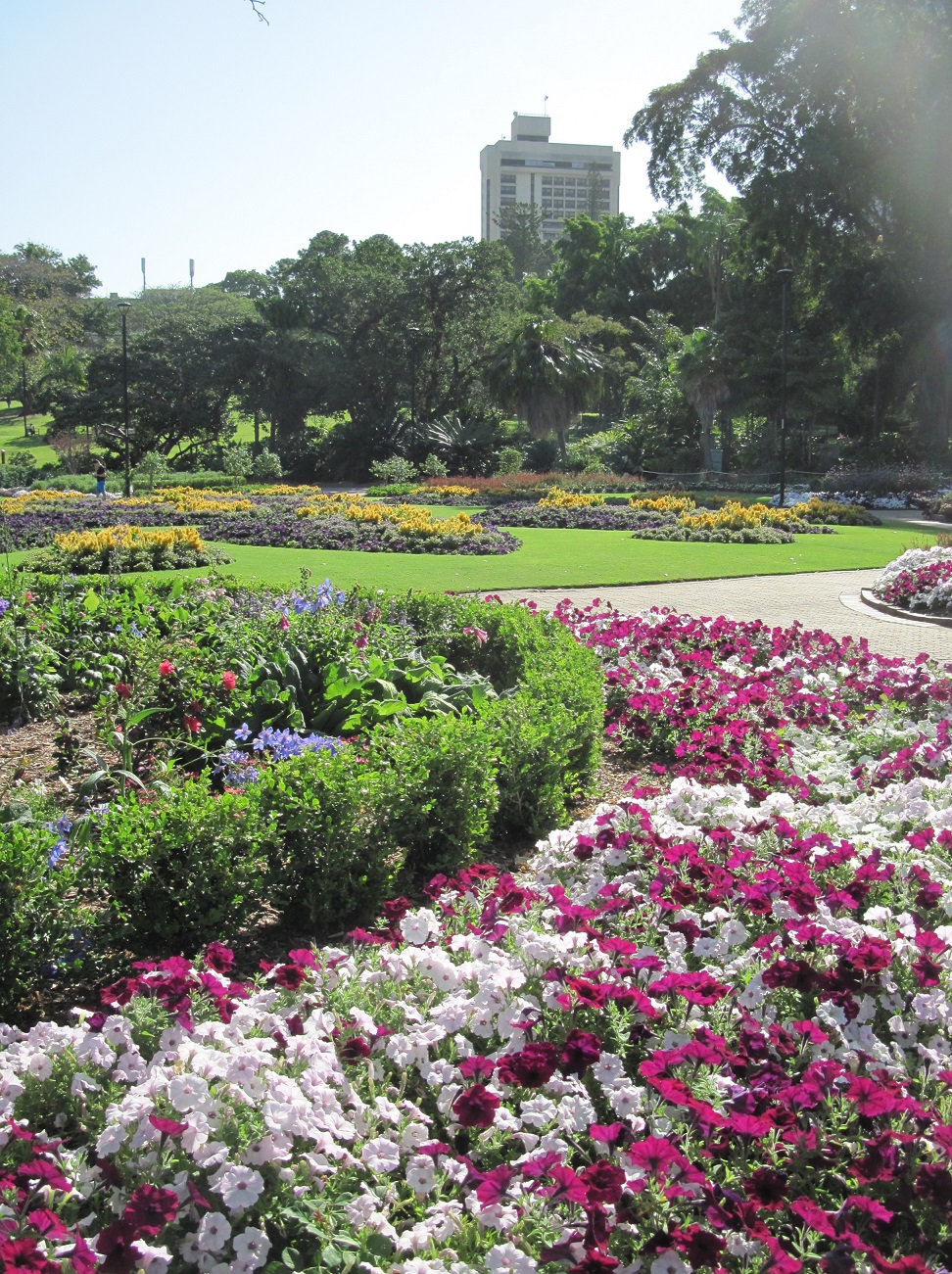
| A view of some of the broad lawns to be found in the Gardens, interspersed with various native and non-native species of trees, planted here over the decades. |
 |
| A palm-ringed ornamental pond near the main entrance at Albert and Alice Streets provides a habitat for waterfowl, lizards, and fish. The upper pond was created between 1958 and 1960, whereas the lower pond was part of the gardens' original natural creek system. |
 |
| Walking paths wind around the perimeter of the ornamental pond. |
 |
| An eastern water dragon, a species of iguanian lizard native to the east coast of Australia. Despite a menacing appearance, eastern water dragons are very shy and dodge into undergrowth at the approach of humans, though they can also jump into water and lie submerged for up to 90 minutes if feeling threatened. |
 |
| Despite heavy urbanisation, Brisbane is home to thousands of these eastern water dragons, which can be found close to water in parks, gardens, and other green spaces. Their powerful limbs and sharp claws make these lizards good climbers, though they can often be found lying perfectly still in the open, basking in the sun. |
 |
| A dusky moorhen watches warily. |
 |
| A family of dusky moorhens, including chicks, sit near the edge of the ornamental pond in the City Botanic Gardens. |
 |
| A wary bush stone-curlew shelters under a shrub, remaining motionless and seeking to blend into the vegetation. These generally nocturnal birds feed on frogs, spiders, molluscs, insects, crustaceans, snakes, lizards, and small mammals. |
 |
| Thick beds of orange and red lilies add a splash of colour around the ornamental pond. |
 |
| A flock of Australian white ibis (Threskiornis moluccus) hunt insects on the broad lawns of the City Botanic Gardens. |
 |
| A Bismarck palm (Bismarckia nobilis), a native of the open grasslands of northern and western Madagascar. This tree is one of many imported species planted in the City Botanic Gardens. |
 |
| Large pods hang off a Kigelia africana, also known as a sausage tree due to the shape of its fruit, which can grow up to two feet long and weigh as much as 15 pounds. |
 |
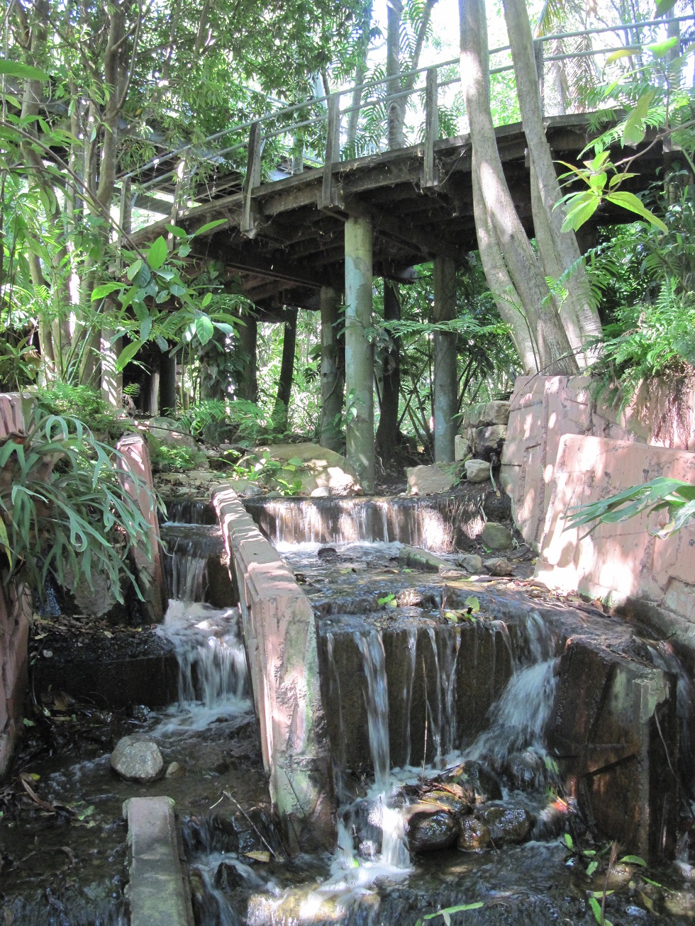
| A waterfall and rockery surrounded by lush tropical vegetation. The waterfall and rockery mark the course of a creek which predate the City Botanic Gardens. |
 |
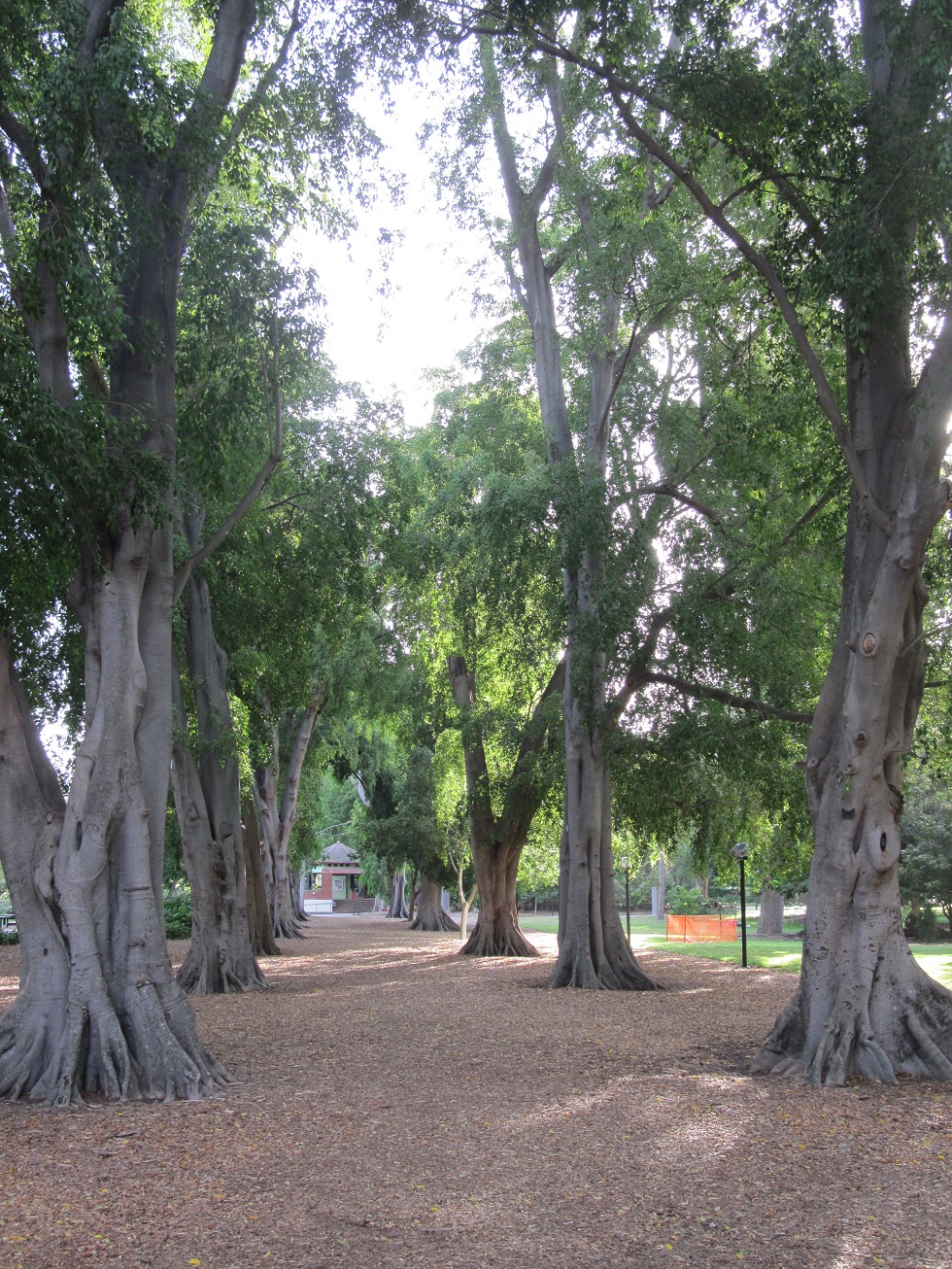
| The branches of Banyan fig trees arch over a pathway in the City Botanic Gardens. Native to India, this species of fig is named after the Banyans, India's merchant caste, who set up their stalls under its sheltering branches. These Banyan figs were planted in the City Botanic Gardens in the 1870s. The Banyan fig sends down aerial roots, which provide secure anchors for the large branches; these aerial roots eventually form trunks, allowing the tree to spread over acres after 500-600 years. |
 |
| A view of the trunk of a Banyan fig tree, showing the aerial roots snaking down from the branches. Along with the imported Banyan figs, this pathway also features native Queensland small-leaved fig trees. |
 |
| Looking north along the Central Path, toward the Albert Street entrance gates, which were erected in 1865 as the first formal entrance to the City Botanic Gardens. The stone used for the wrought-iron fence along the Alice Street perimeter was cut by convicts from stone salvaged from the demolished Brisbane Jail. |
 |
| Towering bamboo line the Central Path, providing a quiet and shady place to relax on one of the many benches situated at intervals along the park's main promenade. The Bamboo Grove features 23 species of bamboo, planted in 1998 to replace a previously-removed bamboo grove elsewhere in the park. |
 |
| A quiet day in the City Botanic Gardens. The Rotunda, an information kiosk, is situated at the fork of the Central Path. |
 |
| The Rotunda is staffed by park employees and volunteers and has event information, maps, and park guides for visitors. |
 |
| The Riverside Gardens Market, hosted along the Central Path in the City Botanic Gardens on Saturday, 26 November 2016. |
 |
| In addition to international food vendors, a variety of merchants sell a range of items, from hand-made jewellery, handicrafts, pottery, rugs, clothing, and art work. |
 |
| A view of the Sri-Chinmoy Peace Garden, located at the fork of the Central Path, beside the Rotunda. The Sri Chinmoy Peace-Blossoms is a global collection of significant and peaceful places dedicated to world peace and friendship. |
 |
| The City Botanic Gardens' Sri Chinmoy Peace Garden was opened on 31 March 1993. |
 |
| The Walter Hill Fountain was designed by Queensland colonial architect Charles Tiffin and constructed by stonemason John Petrie, being completed in 1867. This drinking fountain, the first ornamental drinking fountain in Queensland, marked the completion of the colony's first major engineering project, the Enoggera Dam, which provided pure drinking water to the city of Brisbane. In 1972, the fountain was dedicated to the City Botanic Gardens' first curator, Walter Hill, who served in this capacity from 1855 to 1881. the fountain is constructed out of Helidon sandstone and marble from Gladstone. |
 |
| A clump of sugarcane and a plaque mark the approximate location where Queensland's sugar industry was born in 1862. In June 1862, City Botanic Gardens curator Walter Hill and Barbadian planter John Buhôt first successfully granulated the juice of sugarcane planted in the gardens as part of a trial of various economic crops. The plaque seen in the photo was erected by the Royal Historical Society of Queensland and the sugar industry in 1962. |
 |
| An Australian white ibis sits atop a sundial in the City Botanic Gardens. |
 |
| An ANZAC pine (Pinus brutia) native to the Mediterranean, where it grows on Turkey's Gallipoli Peninsula. This tree was propagated from seeds collected from the Lone Pine area of Gallipoli in 1979 and commemorates the 1915 Battle of Gallipoli, fought by soldiers of the Australian and New Zealand Army Corps (ANZAC). |
 |
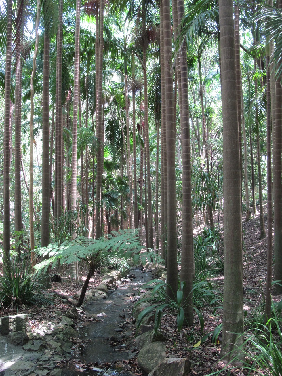
| Looking south on Bunya Walk, the promenade running parallel to the Brisbane River. The bunya pines (Araucaria bidwillii) located here were planted between 1858 and 1867, and the species is named after Sir John Carne Bidwill, a notable colonial botanist and Commissioner of Lands. |
 |
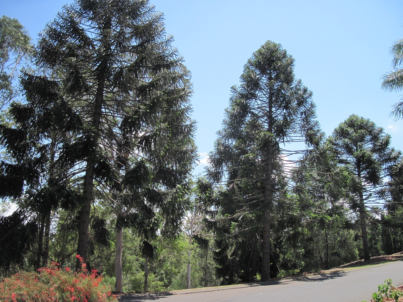
| A circle of Cuban royal palms (Roystonea regia), planted in 1919. The Cuban royal palm can grow to a height of 40 metres and live 200 years. |
 |
| The ring of Cuban royal palms are located in a part of the gardens formerly called Queens Park and used as a playing field. In 1919, tons of soil from the newly-graded riverbank were dumped in Queens Park and the playing fields were replaced by plantings of exotic shade trees, including these Cuban royal palms. |
 |
| Weeping Fig Avenue, planted in the 1870s as a barrier between the northern boundary of the City Botanic Gardens and Queens Park, prior to the latter's incorporation into the gardens. |
 |
A playground provides a fun stop for families.
|
 |
| The sign at the George Street entrance to the City Botanic Gardens. |
 |
| Modernist sculpture in the City Botanic Gardens, with the Brisbane Skytower under construction in the background. When completed in 2018-19, the 90-storey Brisbane Skytower will soar 890 feet over the city and host 1,138 one-, two-, and three-bedroom apartments, along with Australia's highest infinity-edge swimming pool, located on an 89th floor recreation deck. |
 |
| This Cook pine (Araucaria columnaris) is the tallest tree in the City Botanic Gardens, named after Captain James Cook, the British navigator who charted much of the South Pacific. The Cook pine can reach up to 60 metres (197 feet) in height and is native to the Isle of Pines in New Caledonia. This tree was planted in February 1868 by His Royal Highness Prince Alfred, Duke of Edinburgh, during the first Royal visit to Australia. |
 |
| A bunya pine, a Queensland native found near the Bunya Mountains in the south and inland from Port Douglas in the north. The bunya pine can reach a height of 50 metres (164 feet) and carries its seeds in cones, each weighing up to 10 kilograms (22 pounds). The seeds of the bunya pine were an important food source for Australian aborigines, while the timber of the bunya pine was used by settlers, especially for butter boxes. |
 |
| The Gardens Club café, located in the former City Botanic Gardens curator's residence. This Art Nouveau-style cottage was built in 1908, and was the third such residence constructed here after two previous residences were destroyed by floods. As built, it featured four bedrooms, a parlour, a dining room, a lounge, maid's quarters, and an office. |
 |
| During the Second World War, the curator's residence was used as a mess hall for Women's Royal Australian Navy (WRAN) personnel, who were billeted nearby. After the war, the building reverted to its original purpose, serving as a residence until the 1980s, when the gardens' last curator retired. During a major redevelopment of the gardens in 1987, the residence was converted into a restaurant and kiosk and re-opened in 1989. |
 |
| This pond is one of two remaining of the original four created in the 1850s along a natural watercourse in the gardens. The ponds were planted with water lilies and stocked with fish. The ponds are home to dusky moorhens and a large Swamp Cyprus, native to the Florida Everglades, separates the two ponds. |
 |
| A view of the Rainforest Garden, near the southern tip of the City Botanic Gardens. In or close to this heavily forested section of the gardens are a mahogany tree planted in 1858 (and likely the first such mahogany tree in Australia); and a macadamia tree, brought from the Queensland bush near Gympie and planted here in 1858. This macadamia tree is believed to be the world's first commercially-grown macadamia, which still produces nuts to this day. |
 |
| A songbird perches in the branches of a tree in the Rainforest Garden. |
 |
| The Bunya Walk pathway near the southern tip of Gardens Point passes mangroves growing in the shallows of the Brisbane River. The mangroves act as a buffer between land and tidal waters during storm surges, and provide a home for fish, crabs, prawns, and birds. Additionally, mangroves are excellent carbon sinks, absorbing up to six times more carbon than undisturbed Amazon forest. |
 |
| The mangrove forest, and a boardwalk through them, was damaged during the 2011 Brisbane floods. These mangroves are tolerant of the salty conditions in the Brisbane River, excreting excess salt from glands in their leaves. The air-absorbing peg roots of the grey mangrove (Avicennia marina) anchor the trees in the oxygen-poor mud of the riverbank. |
 |
| One of Queensland's original twelve 24-pounder cannons, cast by the Carron Company ironworks in Scotland between 1797 and 1810 and shipped to the colony in 1862 aboard the immigrant ship Clifton. Deployed in various locations throughout Queensland in the late-1800s for defence purposes, the cannons eventually ended up as ornaments in various towns and cities in the state. This cannon, serial number 63914, was cast in 1803 and formed part of the artillery battery installed in Queens Park (now a part of City Botanic Gardens. It was moved to its present location in the gardens in 2015. |
 |
| Looking across the Brisbane River at Kangaroo Point cliffs. The rock of Kangaroo Point was formed from volcanic ash 220 million years ago and shaped by the flow of the Brisbane River. Beginning in the 1820s, stone was quarried from the cliffs and used in constructing buildings in Brisbane. Queensland-grown wheat was shipped to South America from wharves at Kangaroo Point, the empty ships returning with exotic plants and ballast rocks that were used in the City Botanic Gardens' rockeries. Today, Kangaroo Point cliffs are a recreation area, especially popular with rock climbers. |
 |
| Sailboats moored in the Brisbane River, with the Story Bridge and some of the city's skyscrapers visible in the distance. |
Queen Street Mall and environs
 |
| Brisbane's pedestrianised Queen Street Mall, the Central Business District's preeminent shopping district. |
 |
| The Queen Street Mall spans 1,600 feet, from George Street at the southwestern end to Edward Street at the northeastern end. The first part of the pedestrian mall, between Albert and Edward Streets, opened in 1982 in advance of the Commonwealth Games, and the second phase, between Albert and George Streets, opened in 1988 in advance of Expo 88. In 1999, the Queen Street Mall underwent a $25 million refurbishment. |
 |
| Today, the Queen Street Mall is home to over 700 retailers, occupying more than 430,000 square feet. Six major shopping centres and arcades, including the Myer Centre, front onto the Queen Street Mall, accounting for the 26 million annual visitors to the Mall. |
 |
| Brisbane's subtropical climate permits alfresco restaurants and bars, as well as an open air performance space on the Queen Street Mall. |
 |
| A franchise of the Pig N' Whistle pub in Queen Street Mall, open 24 hours a day, seven days a week. |
 |
| A large steel framework and glass canopy covers the intersection of the Queen Street Mall and Albert Street, serving as the gateway to the Mall. |
 |
| The Treasury Hotel, housed in the former Executive Building at George and Elizabeth Streets. Brisbane's tallest skyscraper, the 46-storey 1 William Street, rises in the distance. |
 |
| A statue of Queen Victoria, 1837-1901, unveiled here in Queen's Gardens on 23 June 1906. The bronze statue is a replica of Sir Thomas Brock's Jubilee Memorial Statue erected in Hove, near Brighton, UK. The 1.5-ton statue sits atop a pedestal of Helidon sandstone and Enoggera granite outside the Executive Building, now the Treasury Hotel. |
 |
| A statue of Thomas Joseph Ryan, 1876-1921, by Bertram Mackennel. Ryan served as Premier of Queensland between 1915 and 1919, but suffered from ill health after a bout of influenza in 1919 and died at the age of 45 while campaigning for federal office. |
 |
| The 39-storey Oaks Casino Towers Hotel on the left and the 31-storey 111 George Street on the right, overlooking Queen's Gardens and the old Executive Building. |
 |
| The William Street entrance to the Treasury Hotel, the former Executive Building (1905). |
 |
| The Treasury Casino occupies an entire city block, bounded by Queen, George, William, and Elizabeth Streets. The neo-Italianate building was originally constructed as Queensland government offices in three stages, between 1886 and 1928. When completed, the Treasury Building housed offices for the Premier, Colonial Secretary, Registrar-General, Treasury, Mines, Works, Police, the Auditor General, the Registrar of Titles, Justice, Public Administration, and the State Savings Bank. Since 1995, the building has been the Treasury Casino, featuring two bars, five restaurants, and eight function rooms. |
 |
| The modernist architecture of Reddacliff Place, located on Queen Street, across from the Treasury Casino. The plaza fronts Brisbane Square, a 38-storey office tower built in 2006. |
 |
| The vacant Bank of New South Wales Building (also known as the Westpac Bank Building) on the pedestrianised section of Queen Street at George Street. The six-storey, neo-classical building was constructed between 1928 and 1930, though the Bank of New South Wales began operating at this site in rented offices as early as 1851. The bank retained its headquarters in this building until 1970, when a new headquarters building was completed. |
Cruising the Brisbane River
 |
| One of the free CityHopper ferries run by public transport operator TransLink. These ferries serve a number of ferry terminals along the stretch of the Brisbane River running through the city core and are very popular with both locals and tourists. |
 |
| The CityHopper ferries feature open-air upper observation decks which offer great views of the city as the ferries make their way up and down the river, seven days a week. |
 |
| A Mississippi-style riverboat moored at Eagle Street Pier in downtown Brisbane. The Story Bridge can be seen in the background. |
 |
| Sitting on a small hill overlooking the Brisbane River across from the Sydney Street Ferry Terminal, Shafston House was completed in 1851. First leased out as a teacher training school, the house was purchased in 1918 by the Australian government for use by servicemen, and used as the Brisbane headquarters of the Royal Australian Air Force in 1969. In 1995, Shafston International College was founded here. Today, Shafston House is a sought-after venue for weddings and other special events. |
 |
| A view of the restaurants and bars at Eagle Street Pier, as seen from a CityHopper ferry. |
 |
| The Story Bridge, Brisbane's best-known icon. Construction of the bridge took five years and 42 days, from 24 May 1935 to 6 July 1940. Forty-one thousand cubic metres of concrete, 1.2 million rivets, 12,000 tonnes of structural steel, and 1,600 tonnes of reinforcing steel were used in building the bridge, which also required 17,500 litres of paint to cover its 105,000 square metres. |
 |
| The Story Bridge extends 1,072 metres overall, and comprises two 82.1 metre anchor spans, two 93.9 metre cantilever spans, and a 93.9 metre suspended span. It stands 80 metres over the Brisbane River and cost $3.2 million dollars to construct. Although free to use today, originally a toll was collected from each vehicle crossing the bridge to help cover the cost of construction: 5 cents per car and 10 cents per truck. |
 |
| Brisbane Customs House, constructed between 1886 and 1889 and used to collect customs duties on imported products. This customs house replaced an earlier, smaller customs office on this site, which had been selected to encourage the construction of wharves on this stretch of the Brisbane River. In 1908, Customs House was acquired by the federal government, the Commonwealth of Australia having been formed in 1901. The Australian Customs Department vacated Customs House in the mid-1980s and the building became redundant when the Port of Brisbane moved to the mouth of the River. Acquired by the University of Queensland and extensively restored between 1991 and 1994. Today, Customs House hosts a restaurant and bar, a function/event space, and an art gallery. |
 |
| Some of the modern skyscrapers lining the river's shoreline in the Central Business District, including Riparian Plaza (2005), One One One Eagle Street (2012), and Riverside Centre (1986). |
 |
| Ominous grey storm clouds gather over the Central Business District and the Brisbane River. Fortunately, the CityHopper ferries feature covered upper decks and an enclosed lower cabin. |
 |
| Kangaroo Point cliffs, as seen from the CityHopper ferry. Rock climbing is a popular activity here, with a local operator renting climbing gear and providing experienced instructors. |
 |
| The Goodwill Bridge spans the Brisbane River, providing pedestrian and cyclist access between Gardens Point in the Central Business District and the South Bank Parklands. The Goodwill Bridge was opened on 21 October 2001 to commemorate the Goodwill Games held in Brisbane that year. A cafe cart at the centre of the span serves coffee, tea, cold drinks, ice cream, and homemade cakes. |
 |
| The skyline of the Central Business District is dominated by 1 William Street, Brisbane's tallest skyscraper, rising 260 metres (853 feet) high. The building was developed for the Queensland Government as part of its plan for a renewed Government Administrative Precinct and opened in October 2016. The elevated Pacific Motorway can be seen snaking along the river shoreline. |
 |
| The Maritime Museum Ferry Terminal, as seen from the CityHopper ferry, which stops here as it plies its way up and down the Brisbane River. |
 |
| A view of the Story Bridge from the shoreline in the Central Business District. |
 |
| Walking across the Story Bridge is a must-do activity for visitors to Brisbane, affording spectacular views of the Brisbane River and the towering skyscrapers of the Central Business District. |
 |
| The view looking southwest from the middle of the Story Bridge, with the Brisbane River curving out of frame in the distance. |
 |
| The Cliffs Boardwalk along the Kangaroo Point cliffs provides expansive views of the Central Business District. |
 |
| The view from the top of Kangaroo Point cliffs, with the City Botanic Gardens across the Brisbane River on the left and the skyscrapers of the Central Business District in the centre and right. Two jet skis race up the river, passing a slower ferry boat. |
 |
| A steep staircase leads down the sheer side of the Kangaroo Point cliffs from River Terrace to the Cliffs Boardwalk. |
Queensland Maritime Museum
Founded in 1971, the Queensland Maritime Museum is housed on the site of the former South Brisbane Dry Dock, located on the south shore of the Brisbane River, across from the Central Business District. The dry dock's construction was prompted by demands for such a facility to provide repair and maintenance services for vessels of the Queensland colonial government. Funding for the dry dock was approved in 1875 and construction commenced the next year using granite imported from Melbourne and local sandstone from the Queensland town of Helidon. As completed in 1881, the dock was 313 feet long and 60 feet wide, though in 1887 it was lengthened to 430 feet to accommodate the vessels of the British India Steam Navigation company, which had a mail contract with the Queensland Government. Coal-fired steam boilers (electric generators from the mid-1920s) powered two centrifugal pumps capable of emptying the dry dock in 3-4 hours, whilst a sluice gate at the head of the dry dock opened to naturally flood the dock with river water. Along with repairing vessels, the dry dock was also used as a swimming pool by the Queensland Amateur Swimming Association from 1899. During the Second World War, when Brisbane became a major Allied base, the South Brisbane Dry Dock was in constant use, servicing 47 vessels of the Royal Australian Navy and 94 United States Navy ships and submarines between 1939 and 1945. The South Brisbane Dry Dock closed in 1972.
Below: The front and reverse sides of the visitor brochure for the Queensland Maritime Museum.
 |
| The pump house of the old South Brisbane Dry Dock, which was built in the 1870s. |
 |
| The 15-tonne Torres Strait pearling lugger Penguin, built on Thursday Island in 1907. Originally named Mercia and used in the pearl shell fishery, the vessel was acquired in 1942 for war service in Papua New Guinea. Returned to the pearl shell fishery after the war, the boat was fitted with a diesel engine in 1956 and, later, was transferred to the Council of Dauan Island (in the Torres Strait) and used as an island service vessel under the name Penguin. Penguin was donated to the Queensland Maritime Museum in 1981. Today, visitors may climb aboard and squeeze into the cramped cabin to learn about the pearl shell fishery and view black and white photos of pearling luggers at work. The pearl fishery was the major industry in Broome and the Torres Strait Islands between 1880 and 1950, with over 300 pearling luggers operating in the region at the industry's height. |
 |
| One of the smooth bore, muzzle-loading 24-pounder cannons cast by the Carron Ironworks in Scotland between 1797 and 1810 and later shipped to Queensland in April 1862 to bolster the colony's coastal defences. This cannon, cast in 1810, was originally placed along the shoreline in the City Botanic Gardens and later moved to another location in the city to serve as a time signal at 1pm each day. The wooden gun carriage is a replica. |
 |
| One of two eight-inch breech-loading guns which served as the main armament aboard the colonial naval vessels Paluma and Gayundah, which arrived in Queensland in 1885. These guns weigh twelve tonnes each and the barrels are 18 feet long. With a range of 7,500 yards, the guns could hurl four different types of shell, weighing up to 180 pounds, against iron ships, boats, troops, or land fortifications. After these guns were decommissioned, they were buried at the Kangaroo Point Naval Store and only rediscovered in 1978 and 1983, respectively, after which they were preserved and donated to the Queensland Maritime Museum. |
 |
| Commonwealth Light Ship (CLS) No. 2, an unmanned navigational aid that was moored on the Carpentaria Shoal in the northern Gulf Carpentaria, 50 miles west of the Torres Strait, between 1926 and 1983. One of four such vessels built at Cockatoo Island Dockyard in Sydney in 1915, the light ship measures 23 metres long and 8 metres wide. Each lightship would spend two years on station whilst a second vessel was in port being refurbished and refitted with 80 new acetylene tanks to power the navigation light; tugs would then tow the refuelled light ship to its station and return with the other light ship for its own refurbishment and refuelling. Each light ship was secured to the seafloor by 180 metres of anchor chain, and after two years on station the decks of the light ship could be covered in up to 100mm of slippery bird droppings. |
 |
| An antique derrick that was part of the equipment of the South Brisbane Dry Dock, used for hauling equipment, tools, scrap metal, and other heavy items on and off vessels undergoing construction or repair. |
 |
| A stern view of HMAS Diamantina, one of 151 River-class frigates built for 19 navies between 1941 and 1944, and the only one of its class preserved as a museum ship. Today, Diamantina rests in a cradle in the historic South Brisbane Dry Dock. She measures a little over 300 feet long, with a displacement of 1,470 tons. Armament consisted of two single-mount 4-inch Mk XVI guns (one each fore and aft), a 24-spigot Hedgehog anti-submarine mortar, up to 100 depth charges, and eight 20mm Oerlikon guns (later replaced by three 40mm Bofors cannons). |
 |
| HMAS Diamantina was built by Walkers Ltd, Maryborough. Launched on 6 April 1944, Diamantina was commissioned into the Royal Australian Navy on 27 April 1945 and served until 9 August 1946, earning the battle honour 'Pacific 1945' for her wartime service in the Soloman Islands. Placed in reserve, the ship was refitted as an oceanographic survey vessel and recommissioned on 22 June 1959, operating out of Fremantle, Western Australia until being decommissioned for the last time on 29 February 1980. Diamantina was subsequently transferred to the Queensland Maritime Museum. |
 |
| During her wartime service, HMAS Diamantina carried a crew of 146 officers and men. A plaque on the quarterdeck marks the location where Brigadier J.R. Stevenson took the surrender of Japanese forces on Nauru on 13 September 1945 and Ocean Island on 1 October 1945. |
 |
The brass nameplate for HMAS Diamantina.
|
 |
| Looking forward along the forecastle deck of HMAS Diamantina. |
 |
| HMAS Diamantina's open compass platform, protected now by a canvass awning. The captain's chair is located forward, with the wood and brass binnacle at the centre. A small door to the right of the captain's chair leads into the asdic (sonar) office, located just off the compass platform and from which sonar contacts would be shouted to the deck officers. |
 |
| One of three 40mm Bofors cannons, this one located on the starboard quarterdeck. |
 |
| The wheelhouse, from where the ship was steered via commands shouted through voice pipes from the compass platform above. |
 |
The Navigating Officer's cabin and chart room.
|
 |
The wireless office.
|
 |
| Banks of heavy radio gear in the wireless office, the ship's communications hub. |
 |
| The small but comfortable sleeping accommodation in the Captain's cabin. |
 |
| The Captain's dining table in his cabin. This cabin was the Captain's living quarters, whereas his much smaller 'sea cabin', located adjacent to the wheel house was used as an office and for brief naps if required to be close to the bridge for long periods of time. The Captain dined in his cabin alone, attended by his steward, though he could invite officers to dine with him on occasion. |
 |
The First Lieutenant's cabin.
|
 |
| A typical cabin for the ship's junior officers, comprising two bunks and a wash basin. |
 |
| Looking down a hatchway to the deck below. |
 |
| A view down one of the ship's passages, showing the watertight doors between sections. |
 |
| A former mess deck now houses a display on the colonial-era Queensland Marine Defence Force and Naval Brigade and the early years of the Royal Australian Navy. The glass case contains artefacts and photos. |
 |
| A scale model of the Queensland Colonial Government gunboat Gayundah. This vessel, and her sister ship Paluma, were ordered by the Queensland Government in the 1880s in response to fears of Russian invasion. Paluma and Gayundah arrived in Queensland in 1885, joining a torpedo boat, the Mosquito, that had arrived the year before. Gayundah is notable for being the first British warship on the Australia Station to operate radio successfully, sending messages from its position in Moreton Bay to the Kangaroo Point Naval Stores in Brisbane in 1903. |
 |
| A scale model of the HMAS Australia, a County-class heavy cruiser of the Royal Australian Navy, which commissioned on 24 April 1928 and served until 31 August 1954. |
 |
| A scale model of the 4,500-ton Perth-class guided missile destroyer HMAS Brisbane, which commissioned into the Royal Australian Navy on 16 December 1967 and decommissioned on 19 October 2001. |
 |
| Another view of one of the passageways aboard HMAS Diamantina. |
 |
| The wardroom, located amidships on the upper deck. The wardroom served as a dining room and recreation space for the ship's officers (though not the Captain, who required an invitation from the First Lieutenant to enter the wardroom). Diamantina's wardroom features a curved bar, a dining table, and settees, and is decorated with ship crest plaques and framed photos of naval ships and the monarch. |
 |
The dining table in Diamantina's wardroom.
|
 |
| Comfortable settees provide officers with a place to relax, converse, enjoy a drink, or read. |
 |
The ship's sick bay.
|
 |
| A bank of shower stalls and sinks for the crew. |
 |
| The engine room, where the ship's two triple expansion steam engines produced 5,500 horsepower, driving twin screws. HMAS Diamantina had a top speed of 20 knots (37 km/h). |
 |
| Looking down into the bowels of the engine room from the catwalk above. |
 |
| HMAS Diamantina's Sperry-built gyro compass, located low in the hull. The gyro compass is a highly accurate mechanical compass that always points to true north, irrespective of magnetic interference. A sign explains the gyroscopic principle at work: 'If a vertical disc is spun at a high stable speed, it will resist turning movement from side to side. That is, it will have a tendency to stay pointing in the one direction. If the disc is mounted on a mounting so that it can rotate from side to side, then as the mounting moves, the disc will keep pointing in the same direction. In a gyro compass, as the ship turns, the gyro compass points in the same direction, true north. Inside the compass, sensors determine the angle between the ship's head and the disc inside the compass, giving the ship's bearing. Electrical signals are then fed to gyro repeaters around the ship, causing the card in the repeater to rotate to give the ship's heading.' |
 |
| One of the seamen's messes, displayed as it would have looked during the ship's wartime service in 1945-46. Up to fifty men slept here in hammocks slung from the deck head and ate at tables underneath. Each sailor was issued with a hammock and a small locker to stow his personal items. In the post-war period, the hammocks were replaced by bunk beds. |
 |
| The ship's galley, where meals for the ship's 140+ personnel were prepared. |
 |
| Boats, cranes, and other shipyard paraphernalia sit beside the pump house at the edge of the South Brisbane Dry Dock. |
 |
| The Bulwer Island Light, also known as the Bulwer Island Range Rear Light, which stood on the reclaimed tidal mangrove island located at the mouth of the Brisbane River between 1912 and 1983. A vessel entering or leaving the Brisbane River was safely in the middle of the bar cutting when the light on this tower was seen to be in line with a light on a lower tower 1.5 km ahead. The tower's frame is hardwood, with corrugated iron cladding. When a new tower was erected on Bulwer Island, this lighthouse was moved to the Queensland Maritime Museum in 1983. |
 |
| The Bulwer Island Light, comprising a cut glass lens and an acetylene-based flasher. The light could be seen from 12 nautical miles distance and was shown through an arc of 15 degrees. |
 |
| The Australasian United Steam Navigation Company tug Forceful, built in Glasgow, Scotland and sent to Brisbane in 1926. During her early career, Forceful assisted merchant ships in and out of their berths on the Brisbane River, around sharp bends in the river, and into dry docks. Between February 1942 and October 1943, the tug served the Royal Australian Navy as HMAS Forceful, operating out of Fremantle, Darwin, and Thursday Island. The advent of more powerful diesel-powered tugs after the war caused Forceful's retirement in 1970 and she was transferred to the Queensland Maritime Museum on 10 June 1971, where she was used for visitor sightseeing cruises until 2006. She is now permanently moored at the museum. (Forceful was closed to visitors in late November 2016 for repairs and refurbishment.) |
Below: A pamphlet on the tug Forceful, available to visitors of the Queensland Maritime Museum.
 |
| A scale model of the Orient Line steamship SS Orion, built by Vickers-Armstrongs in Barrow, UK and launched on 7 December 1934. The ship measured 665 feet (202.7 metres) in length, 82 feet (25 metres) wide, and displaced 23,371 tonnes. Top speed was 21 knots. As built, Orion carried 486 first-class and 653 tourist-class passengers, and arrived in Brisbane in November 1935 on her maiden voyage from London, serving the Orient Line's Australian service. Requisitioned as a troop ship in 1939, Orion was refitted and returned to passenger service after the Second World War, being converted in 1960 to carry 1,600 tourist-class only passengers. In 1963, Orion was retired and used as a floating hotel in Hamburg, Germany during the International Gardening Exhibition until being sold for scrap at the end of 1963 and subsequently broken up in Belgium. |
 |
| A scale model of the SS Amarapoora, built for the Glasgow-based Henderson Line in 1920. The ship operated between Glasgow and Rangoon in Burma, but was used as a hospital ship (and later as a troopship) during the Second World War. Converted to a migrant ship in 1948, Amarapoora made several voyages between Europe and Australia, and was renamed Captain Hobson in 1951, thereafter serving the New Zealand assisted passage scheme and as a troopship until being scrapped in 1959. |
 |
| A scale model of the steam tug Coringa, built in 1913 in Dumbarton, Scotland and operated as a salvage tug based in Brisbane. |
 |
| A scale model of the SS Otranto, one of five 20,000-tonne liners built for the Orient Line in the 1920s. Launched by Vickers-Armstrongs Ltd. on 9 June 1925, Otranto measured 658 feet (200.6 metres) long and 75 feet (22.9 metres) wide, with a top speed of 20 knots. She carried 572 first-class and 1,114 third-class passengers, with service between London and Brisbane commencing in January 1926. Requisitioned by the British government as a troopship in 1939, Otranto was handed back to the Orient Line in 1948 and refitted as a one-class ship carrying 1,412 tourist-class passengers. Otranto operated until being sold for scrap and broken up in 1957. |
 |
| A scale model of the paddle steam yacht Lucinda, built in Dumbarton, Scotland in 1884 for the Queensland Government. Measuring 165 feet (50 metres) long and 25 feet (7.5 metres) wide, Lucinda was one of the first vessels with electricity installed. The vessel contained sleeping accommodations for 40 passengers and was used primarily to transport the Governor of Queensland, Members of Parliament, and other dignitaries on visits to towns in central and north Queensland. In March 1891, Lucinda ferried the Queensland delegates to the First National Australasian Convention in Sydney, which selected a committee to draft legislation for the federation of the Australian colonies in 1901. The final draft of a Bill embodying the Constitution of what was to become the Commonwealth of Australia was prepared on board Lucinda in the Hawksbury River. In the years after Federation, Lucinda was used as a Moreton Bay sightseeing vessel for schoolchildren, decommissioned in 1921, sold and partially dismantled in 1924, used as a coal barge until 1937, beached on Bishop Island and, in the early 1950s, finally cut up for scrap. |
 |
| A scale model of the Orient Line's Royal Mail Ship (RMS) Orcades in a display on migration to Australia. Launched on 14 October 1947, the Orcades carried thousands of migrants to Australia and later served as a cruise ship until being withdrawn from service on 13 October 1972. She measured 709 feet (216.1 metres) long and 90.6 feet (25 metres) wide, with a top speed of 22 knots. The model depicts her with the white hull paint she received during a 1964 refit, which replaced the traditional corn-coloured hull paint used by the Orient Line. |
 |
| A scale model of the Queensland Maritime Museum's steam tug Forceful, built by Alexander Stephen and Sons Ltd. in Govan, Scotland in 1925. Forceful measured 121 feet (36.88 metres) long and 27.1 feet (8.26 metres) wide, with a displacement of 288 gross tons. Her powerful triple expansion reciprocating steam engine generated 1,050 indicated horsepower and drove the tug at a top speed of 13 knots. |
 |
| A gallery devoted to the history of light houses, from ancient times to the present, occupies the lower level. The upper gallery traces the history of migration to Queensland, including the shipping lines and ships that carried thousands of settlers to the new colony from its creation in 1859. |
 |
| Brisbane City Hall, completed in 1930 in the Greek Classical Revival style. This grand, and very expensive building, replaced a smaller town hall on Queen Street. Today, the city hall building is one of Brisbane's most significant heritage buildings, and is the largest town hall in Australia. At the time of its completion, Brisbane City Hall was the second largest construction project in Australia after the Sydney Harbour Bridge. 'The Progress of Civilisation in Queensland', the bas relief sculpture above the columns, was carved in place and took noted Brisbane sculptor Daphne Mayo fourteen months to complete. A thorough restoration of Brisbane City Hall was completed between 2010 and April 2013, at a cost of $215 million. |
 |
| One of two bronze lion sculptures flanking the entrance to Brisbane City Hall. |
 |
| Notwithstanding the tropical heat (30 degrees C in the daytime), a Christmas tree stands in King George Square, outside Brisbane City Hall. |
 |
| The main lobby of Brisbane City Hall. Display boards on the rear wall tell the story of the building's construction, as well as its 2010-2013 restoration. |
 |
| The lobby features high vaulted ceilings, chandeliers, and marble panelling. |
 |
| The City Hall franchise of the Shingle Inn, a Brisbane chain of bakery restaurants. The first Shingle Inn opened on Edward Street in 1936 and has been a favourite of Brisbanites since then, as well as many American servicemen stationed in the city during the Second World War. Today, over 50 Shingle Inn franchises are in operation throughout Queensland, New South Wales, the Australian Capital Territory, Victoria, and in the city of Perth. |
 |
| Patio-style seating outside the restaurant. |
 |
| The interior of the Shingle Inn, with it's Tudor-style woodwork, brown shingle walls, and banquettes reminiscent of church pews. The stored fittings of the original Shingle Inn of 1936 were installed in a part of Brisbane City Hall following the building's restoration in 2013; this recreated the layout and Tudor-era feel of the original restaurant. |
 |
| A typical two-seater banquette at the Shingle Inn. |
 |
| A mid-afternoon stop at the Shingle Inn for a pot of tea and a slice of their famous lemon meringue pie, topped with vanilla ice cream. Notably, the sugar bowls bear the engraved names of the Shingle Inn and other Brisbane cafes (Renoir, Websters, Yorktown) that were owned by the two families that operated them. |
 |
| The auditorium in the centre of Brisbane City Hall is topped by a copper dome with 8,500 light emitting diodes that display a light show. |
 |
| The auditorium can seat up to 2,500 people and, with an industrial kitchen installed as part of the 2010-2013 renovations to City Hall, hosts many functions and events. |
Below: A floor plan for the Museum of Brisbane.
Below: Some interesting statistics on Brisbane and its people, which supports the '100% Brisbane' interactive exhibit showcasing interviews with a cross section of Brisbanites. The exhibit allows visitors to use computers to answer various statistical questions that are then added to a growing database and tabulated and displayed on large screens in the exhibit.
 |
| The Museum of Brisbane is a free museum housed on the third floor of City Hall and operated by the Council of Brisbane. Its exhibits tell the story of Brisbane's founding and major events in its history, showcasing some of the 5,000+ artefacts and works of art comprising the City of Brisbane Collection, created in 1859. |
 |
| 'Loading coal, Kangaroo Point, 1889' by British-born artist Isaac Walter Jenner. |
 |
| A builder's' model of Her Majesty's Cutter Mermaid, 1817. Whilst in command of Mermaid, explorer and surveyor John Oxley discovered the Brisbane River in 1823, though he was not the first white man to locate the river; that distinction goes to three lost lumberjacks who were shipwrecked on Moreton Island during a storm. One of the three led Oxley to the river in a small boat. |
 |
| 'The Founding of Queensland and the Birth of Brisbane,' painted by John Alcott in 1928. The painting shows Lieutenant Henry Miller, the first Commandant of the Moreton Bay Penal Settlement surveying what is now Brisbane's Central Business District. |
 |
| A pair of leg irons placed on convicts at the Moreton Bay Penal Colony. All convicts were required to wear leg irons for some period of time, but some were required to wear them for the full seven years of their sentence. The irons were fashioned by convict blacksmiths and attached with a rivet. Chain-gang members worked on farms and treadmills used to grind grain into flour, whilst skilled convicts were used for specialised trades, such as carpentry, cabinet-making, and soap and candle manufacturing. |
 |
| A view of the Museum of Brisbane, including the gallery devoted to the story of the city's founding and settlement. |
 |
| A gallery devoted to the story of Brisbane's former network of electric trams, which was the main means of transportation in the city between 1897 and 1969, when the last tram was taken out of service. |
 |
| A destination roll from tram #346, which operated on the Kalinga Line, Route 73. At its height (1952), Brisbane's tram network comprised 108 kilometres of track, with trams running through the city, as well as numerous suburbs: north to Chermside, Kalinga, and Clayfield, south to Salisbury and Mt Gravatt, west to Toowong, Bardon, and Enoggera, and east to Bulimba and Carina. To the right of the destination roll is an interactive screen that allows museum visitors to read about notable events in the history of the city's trams. |
 |
| A photo of one of the over 1,400 reported tram accidents between January 1942 and August 1943. In the worst accident, on 6 September 1943, a military truck being driven on the wrong side of the road by a U.S. Army private collided with a tram, overturned and caught fire. Five women died, whilst 33 others suffered burns and other injuries. With tens of thousands of Allied servicemen based in Brisbane or transiting through the city en route to operations, and with petrol rationing reducing car usage, Brisbane's trams saw a spike in ridership, carrying 160 million passengers in 1944-1945. |
 |
| A gallery devoted to the design and construction of Brisbane's iconic Story Bridge. |
 |
| A view of Brisbane City Hall, including its impressive 70-metre tall clock tower, modelled on St. Mark's Campanile in Venice, Italy. The clocks on all four sides of the tower are the largest in Australia, measuring five metres across. |
 |
| Outside City Hall, an equestrian statue of King George V, after whom King George Square is named. |
 |
| The Petrie Tableau was commissioned for the Australian bicentennial celebrations of 1988 and serves to honour the pioneering families that settled Brisbane. Specifically, the tableau depicts the departure of Andrew Petrie for an inland expedition from the Moreton Bay Settlement in 1842. Petrie's wife hands him a water bottle, while his children play nearby, the eldest son (who would later go on to be Brisbane's first mayor), is holding the horse's reins. |
South Bank Parklands
 |
| The South Bank Boardwalk running along the southern shoreline of the Brisbane River, across from the Central Business District. The South Bank Parklands were created on the former site of the World Exposition of 1988 and opened to the public on 20 June 1992. |
 |
| The Epicurious Garden, featuring vegetables, herbs, and other edible plants. A statue of Confucius, donated in 2009 by the Ji'nan Municipal Government in Shandong Province, China to mark the 150th anniversary of Queensland's founding, sits at the top of the lily pond. |
 |
| A rainforest park in the South Bank Parklands, with a small, man-made island in the centre of a pond. a footbridge provides access to the island, which hosts a barbeque and picnic site. |
 |
| The Streets Beach lagoon at South Bank Parklands is a 2,000-square metre, free-form concrete pool ringed with 4,000 cubic metres of sand brought in from the Rous Channel in Moreton Bay. Palms and sub-tropical plants surround the beach, which also provides seating and picnic areas. |
 |
Families play in the shallow pool and water park, part of Streets Beach.
|
 |
| Streets Beach lagoon uses chlorinated and recycled fresh water, enough to fill five Olympic-sized swimming pools. |
 |
| A signpost in the shape of a surfboard counts down to the XXI Commonwealth Games, to be hosted in the Gold Coast of Queensland in April 2018. |
 |
| A quiet morning at Streets Beach, before the onslaught of bathers. |
 |
| A rocky creek winds its way through lush vegetation as it feeds into Streets Beach lagoon. |
 |
| The deep end of Streets Beach lagoon provides a swimming area, whereas those wishing to wallow in the warm water can do so at the shallow end. |
 |
| Looking down the Ernest Street Parkway at Streets Beach, where a variety of restaurants, bars, and souvenir shops cater to visitors. |
 |
People stroll along the South Bank Boardwalk.
|
 |
| The Rainforest, through which a boardwalk winds. |
 |
| The Rainforest hosts an array of subtropical trees and plants arranged around man-made water features. |
 |
| A sitting area in the Rainforest, which allows visitors to wind their way through a reproduced subtropical rainforest environment right in the centre of South Bank Parklands. |
 |
| The State Library of Queensland, the state's main reference and research library. The State Library moved to its current location in the Queensland Cultural Centre in 1988. |
 |
| An extensive three-year renovation saw the State Library re-open in November 2006 |
 |
| A 5.5 tonne bronze elephant sculpture, called 'The World Turns', installed outside the Queensland Gallery of Modern Art (GOMA) in November 2012. The sculpture, by New Zealand artist Michael Parekowhai, cost $1.5 million and was floated down the Brisbane River on a barge before being lifted into its final resting place by crane. |
 |
| The William Jolly Bridge, an Art Deco-style, steel-framed arch bridge with a veneer of concrete. The bridge was opened by Queensland Governor Sir John Goodwin on 30 March 1932, and named after Greater Brisbane's first Lord Mayor, William Jolly, on 5 July 1955. |
Brisbane Botanic Gardens Mount Coot-tha
Below: The front and reverse sides of a brochure available to visitors to the Brisbane Botanic Gardens Mount Coot-tha.
Below: A map of Brisbane Botanic Gardens Mount Coot-tha.
Below: Another visitor guide and map for the Brisbane Botanic Gardens Mount Coot-tha. This map, from 2014, predates the one above and thus does not reflect the southern extension of the lagoon and associated gardens opened in 2015.
 |
| The Brisbane Botanic Gardens Mount Coot-tha are located 7 kilometres west of downtown Brisbane, at the foot of Brisbane's tallest mountain, Mount Coot-tha. Established in 1970 and opened to the public in January 1976, these gardens cover 56 hectares and are managed by the Brisbane City Council. |
 |
| Brisbane Botanic Gardens Mount Coot-tha are Queensland's premier subtropical botanic gardens, comprising more than 20,000 plants from 5,000 species from around the world, arranged in thematic and geographic displays. The single largest section of the gardens is devoted to Australian native plants, covering fully half of the property. |
 |
| The newest section of the gardens is a four-hectare area opened in 2015 and featuring a new lagoon, a kitchen garden, a conservation walk, and a playground. |
 |
| The visitor information building at the Brisbane Botanic Gardens Mount Coot-tha. It is from here that a free minibus tour of the gardens departs every day at 10:00 am. |
 |
| The Arid Region Plants section of the gardens, featuring giant aloe plants, agave, and other succulents, a variety of cacti, 50-year old pony tail plants native to Mexico, and baobab trees from Africa. This garden mimics conditions in a desert. |
 |
| Another view of the Central American and African
plant species in the Arid Zone. |
 |
| The Cacti and Bromeliad House, providing ideal conditions for plants from subtropical America and Africa. |
 |
| A wide variety of cacti and bromeliads show off a staggering range of shape and colour. |
 |
| A baobab tree (Adansonia digitata), a native of Africa but related to the baobabs of Western Australia. The baobabs of the Brisbane Botanic Gardens Mount Coot-tha flowered for the first time in February 1995. |
 |
| The Tropical Display Dome, set amongst the plants of the Arid Zone, opened in December 1977. It measures 28 metres in diameter and 9 metres in height. |
 |
| The Tropical Display Dome's roof is made up of tinted acrylic bubble panels in an aluminium frame, which maintain a constant interior temperate of 24-28 degrees Celsius and humidity of 2 percent. |
 |
| With the glass dome creating the perfect humid atmosphere inside, the Tropical Display Dome features a wide range of shrubs, climbers, epiphytes, and small trees from the tropics that cannot normally be grown in Brisbane. Climatic and nutrient conditions are constantly monitored by staff and corrected as required, and the soil comprises a sterile mix of sand, peat moss, and dirt. |
 |
| A large pond in the centre of the Tropical Display Dome assists in maintaining the required high level of humidity and also provides a home for Redclaw Crayfish and Jade Perch. The water is maintained at a temperature of approximately 28 degrees Celsius. |
 |
The geodesic roof of the Tropical Display Dome.
|
 |
| The entry to the Fern House, opened in July 2002. The Fern House displays over 80 different species and varieties of ferns, including those that grow on rocks, on trees, and in the water. Walls and shade cloth provide the ideal growing conditions: high humidity, protection from wind, some shade, and moist soil. |
Below: The front and reverse sides of a brochure available to visitors to the Fern House at the Brisbane Botanic Gardens, Mount Coot-tha.
A shaded boardwalk takes visitors past the numerous fern species on display.
 |
| Ferns are primitive plants that do not flower, being found in fossil records from 200 million years ago. |
 |
| A Giant Fern (Angiopteris evecta), a species whose fronds can reach lengths of 4-5 metres. Australian aborigines extracted an edible starch (sago) from the pith of this fern, whilst in Asia the rhizome is used to reduce fever. |
 |
A display of water-loving ferns.
|
 |
| Tree ferns, including Cyatheaceae and Dicksoniaceae. |
 |
| A creek runs through the Exotic Rainforest section of the gardens, which showcases trees, shrubs, and vines native to other countries, planted in deep valleys of high humidity caused by various streams and waterfalls. |
 |
| A picturesque series of waterfalls course through a conifer garden. |
 |
| The pathway winds through the gardens, surrounded by various exotic tree species. |
 |
| A shaded, quiet pond in the middle of the Exotic Rainforest section. |
 |
A footbridge crosses the pond.
|
 |
| The Bonsai House is home to a diverse collection of carefully sculpted miniature trees. According to helpful signboards, the art of bonsai originated in China, where nature's own bonsai, shaped and dwarfed by harsh winds and poor growing conditions, were taken from the wild and cultivated in pots. Bonsai cultivation became popular in Japan in the 11th century under the influence of Zen Buddhism and, over the next four centuries Japanese bonsai became a highly ritualised artistic discipline. |
 |
| The Brisbane Botanic Gardens Mount Coot-tha holds approximately 300 bonsai plants in its collection, with as many 100 on display at any one time. Japanese bonsai cultivation was governed by a strict code, with the shapes and positions of branches and trunks carefully chosen. Bonsai aims to recreate nature in an idealised miniature landscape. |
 |
| The Bonsai House opened in November 1999 and its collection contains miniature versions of figs, conifers, camellias, azaleas, and maples, some of which are over 80 years old. |
 |
| An artfully manicured bonsai pine tree. Bonsai was first exhibited at the 1878 World's Fair in Paris, though it only gained widespread popularity in the West after the Second World War, when many servicemen brought back specimens as souvenirs of Japan. |
 |
| A stream runs past the Palm Tree Lawn, with its open square of grass and quaint pavilion, one of a handful of sites rented for weddings and other events. |
 |
| The Japanese Garden, originally installed around the Japanese Pavilion at World Expo 88 and recreated at the Brisbane Botanic Gardens Mount Coot-tha as a gift of the Japanese people. |
 |
| Stepping stones cross a stream in the Japanese Garden. |
 |
| A waterfall and stream in the Japanese Garden, surrounded by native and exotic plant species suitable for Brisbane's subtropical climate. |
 |
| Carefully tended lawns and shrubs of the Japanese Garden. |
 |
| The serene atmosphere of the Japanese Garden is meant to encourage contemplation meditation. |
 |
| A quiet pond ringed by lush vegetation at the centre of the Japanese Garden. The garden is designed in the tsuki-yama-chisen (mountain, pond, stream) style, with the main visual elements being the waterfall, the stream, and the pond. A mound, lawn, and a viewing arbour complete the garden. |
 |
| The main gate into the Japanese Garden. A plaque near the entrance to the garden is dedicated to the memory of Mr Kenzo Ogata, the Japanese Garden's designer and a master in the art of landscape architecture, and is dated 24 March 1988. |
 |
| The Bamboo Walk, located near the Japanese Garden, features many different species of these giant members of the grass family. One of the most versatile plant species, bamboo has been used as a food source, as building material and scaffolding, in paper making, for furniture, and for musical instruments. Some bamboos have been known to grow one metre per day. Bamboo species are either running (monopodial) or clumping (sympodial). Running bamboo, introduced into Australia, is an invasive species that sends strong roots out that form new stems (culm) in a short period of time, such that large areas of land can be choked out by these fast-growing plants. In contrast, clumping bamboo species do not spread and remain more compact, also growing faster and being structurally superior to running bamboo. All of the bamboo species featured here are of the clumping variety. |
 |
| The Conservation Walk, which winds up a hill
with a lookout at the top, features an assortment of Australian plant species. |
 |
| A stand of grass trees (Xanthorrhoea), a very slow-growing Australian native plant. The tree on the right has a flower spike (scape), some of which can measure four metres long. The slow growth rate of Xanthorroea means that it can take up to 30 years to achieve a plant with a significant trunk, while a plant several metres tall can be hundreds of years old. |
 |
| Subtropical plants, including cycads, palms, and palmettos along the Conservation Walk. |
 |
| Water lilies cover part of the lagoon in the area of the gardens devoted to temperate region plants. |
 |
| A stand of sugar cane in the Demonstration Garden, which features various economic crops that were introduced to Queensland. |
 |
| Papaya and banana plants in the Demonstration Garden. Other food crops grown here include coconut palms, tea, and coffee. |
 |
| A quiet, sunny afternoon at the lagoon. The lagoon is home to various fish, ducks, ibis, dusky moorhens, turtles, eastern water dragons, and insects, whilst nocturnal visitors include bats, possums, and snakes. |
 |
| This end of the lagoon is shaded by the Bamboo Grove, planted in the 19th century. |
 |
| A waterfall in the subtropical rainforest. |
 |
| A stand of bottle palms (Hyophorbe
lagenicaulis), native to Round Island, Mauritius. |
 |
| A lookout in the far western end of the gardens. |
 |
| The observation deck of the lookout provides expansive views over the dense foliage of the rainforest, with downtown Brisbane seen in the distance. |
 |
| The skyscrapers of Brisbane's Central Business District, as seen from the Brisbane Botanic Gardens at Mount Coot-tha. |
 |
| A large cycad in the subtropical rainforest section of the Australian Plant Communities Trail. |
 |
| The Palm Grove features a variety of palm species growing alongside a creek, including bangalow palm (Archontophoenix cunninghamiana), solitaire palm (Ptychosperma elegans), Carpentaria palm (Carpentaria acuminata), and Alexandra palm (Archontophoenix alexandrae). |
 |
| The Australian Plant Communities Trail winds around this artificial lake. This part of the gardens covers 27 hectares, with conceptual development and plantings beginning in 1984. Plant species featured here include those native to northeast Queensland, southeast Queensland, and northern New South Wales, with an emphasis on rare and endangered plants, particularly rainforest species. Zones within this area of the gardens include open eucalypt forest, heathland, wetlands, tropical rainforest, subtropical rainforest, and eucalypt/acacia woodland. |
 |
| A towering bunya pine (Araucaria bidwillii) in the Bunya Forest section of the gardens. Bunya pines can grow to over 40 metres in height and were once common in southeast Queensland, before the logging industry cut down many of the bunya forests. |
 |
A stand of bunya pines.
|
 |
| Lush vegetation along a rocky creek and waterfall, which creates the necessary micro-climate for rainforests. |
 |
| A stand of Bismarck palms (Bismarckia nobilis), native to Madagascar, along with tropical plants. |
 |
| Colourful crown of thorns 'Poysean Group' (Euphorbia x lomi), a flowering succulent plant native to Thailand. |
 |
| A large royal poinciana (Delonix regia), a member of the bean family and grown as an ornamental tree. It is named for Phillippe de Longvilliers de Poincy, the Governor of Saint Christophe (St Kitts) in the 17th century. The royal poinciana is native to the dry deciduous forests of Madagascar. |
Mount Coot-tha Lookout
The Mount Coot-tha Lookout, also known as One-Tree Hill, was built between 1918 and 1950; however, Brisbane residents had been escaping to the top of the mountain for its spectacular views and fresh air as early as the mid-1800s and the mountain and 1,500 acres around it had been officially reserved for public recreation in 1880. Today, visitors to Mount Coot-tha Lookout can drive to it via Sir Samuel Griffith Drive, hike up on footpaths, or take a #471 bus from downtown Brisbane.
 |
| The Mount Coot-tha Lookout offers spectacular views of Brisbane and its surrounding region, including Moreton Bay. |
 |
| Terraced observation platforms offer clear views in all directions, whilst signboards provide a history of the lookout and information on local wildlife. |
 |
| Today's Mount Coot-tha Lookout hosts a snack bar and a more formal sit-down restaurant deigned in colonial style, with terracotta tiled roofs and terraced sitting areas hedged by native plants. |
 |
| The skyscrapers and sprawl of Brisbane, as seen from the top of Mount Coot-tha. |
 |
| Visitors enjoy a gloriously sunny day atop Mount Coot-tha, taking in the spectacular views all the way to the azure waters of Moreton Bay. |
 |
| When a cold drink and an ice cream just aren't enough, the Summit Restaurant offers a pleasant option for more formal dining. |
 |
| Brisbane and its suburbs sprawl across the horizon. Brisbane is, geographically, Australia's largest municipality, comprising 185 suburbs and four islands accommodating over 1.1 million residents and covering 1,340 square kilometres. |
 |
| Telescopes allow visitors to take a closer look at Brisbane in the distance. |
 |
| The greenery of the gum trees and other subtropical vegetation gives way to houses, motorways, and skyscrapers of bustling Brisbane. |
 |
| A closer view of Brisbane courtesy of a zoom lens, as seen from the top of Mount Coot-tha. |
MacArthur Museum Brisbane
 |
| The AMP Building, the former Queensland headquarters of the Australian Mutual Provident Society, completed in 1934 on the southeast corner of Queen and Edward Streets. Brisbane's largest and most modern office block at the time, the building featured a number of innovations, including the use of bolts instead of rivets, the inclusion of a reinforced concrete roof, and 1,150 tonnes of steelwork that made it one of the strongest buildings in the city. For this reason, the building was chosen to house the headquarters of General Douglas MacArthur, who established his South West Pacific Command in Brisbane on 20 July 1942. Level 8 of the building houses the MacArthur Museum, which tells the story of the general's time in Brisbane between 1942 and his return to the liberated Philippines in 1944. |
 |
| The card which visitors to the MacArthur Museum Brisbane receive upon entry is a replica of the pass issued to visitors to General MacArthur's South West Pacific Command headquarters. |
 |
| Just inside the entrance to the museum is a display panel telling of Douglas MacArthur's early life and career. |
 |
| A small theatre features display boards on the history of the Second World War, wartime activities and events in Brisbane, and a television playing a loop of film footage of wartime Brisbane. The National Manpower Directorate was established with the power to determine who would be exempt from war service, to conscript labour, to redeploy employees to industries of higher priority, and to police anyone not contributing to the war effort. |
 |
| A display on wartime Brisbane. By mid-1943, nearly 100,000 Allied troops were stationed in Brisbane, and security restrictions affected almost every aspect of life for the city's residents. All Brisbane citizens were required to register for the war effort and were issued identity cards, whilst travel outside the city was restricted, pub hours were shortened, beer supplies reduced, schools closed, and publications and private correspondence censored. In March 1942, production of all non-essential goods was banned and petrol was rationed. After mid-June 1942, food and footwear were rationed via a coupon system. |
 |
| The service tunic and slouch hat of a lance-corporal of the 2/25th Battalion, Australian Imperial Force, 1943. |
 |
| A display on the contribution of Queensland Railways to Allied victory in 1945. Despite the Queensland Railways having only a narrow gauge single track and few staff due to Depression era hiring limitations, over the course of the Second World War, the railway transported hundreds of thousands of troops, along with their food, equipment, fuel, and ammunition, as well as thousands of tonnes of supplies for the construction of roads and airfields. Queensland Railways also provided ambulance trains to transport injured soldiers arriving in North Queensland from New Guinea and Pacific Island battlefields. Railway workers were categorised as essential services, and were not allowed to enlist in the military, whilst recreational leave was forbidden from December 1941. During the war, railway mileage increased by 50 percent, passenger numbers grew by 80 percent, and 70 hour work weeks were common for railway employees. |
 |
| A display on the air war and Brisbane's military aviation infrastructure. In addition to General MacArthur's headquarters, the AMP also hosted the headquarters of the Allied Air Force, the Royal Australian Air Force's Queensland headquarters, and 108 Fighter Sector headquarters. A large network of airfields in and around Brisbane provided secure bases for hundreds of Allied aircraft, with Eagle Farm, Archerfield, and Amberley being the principal hubs. The base at Amberley was a major centre of aircraft assembly, maintenance, and repair. |
 |
| The MacArthur Museum Brisbane's displays detail various aspects of the war effort, General MacArthur's conduct of operations, and the impact of the war on Brisbane residents. The long table seen here was used by General MacArthur in his conference room, here in his headquarters. |
 |
| Examples of wartime posters put up in the Brisbane area, encouraging citizens to conserve petrol, food, scrap metal, coal, gas, and electricity, as well as exercise discretion in their conversations in public. |
 |
| Ration cards provided to Brisbane residents to help conserve such things as meat and clothing, as well as a booklet with wartime economy recipes and a booklet on knitting (to assist in the economical production of clothing). |
 |
| A display on the naval war effort in Brisbane, which served as the headquarters of Allied naval forces in South West Pacific Command and an important supply and repair base. Jetties and dry docks on Brisbane's riverfront serviced hundreds of destroyers, corvettes, minelayers, submarines, and motor launches, and Brisbane shipbuilder Evans Deakin also built 11 warships during the war. Of note, it was in this headquarters that the United States Navy units operating in support of MacArthur's South West Pacific Command were amalgamated to form the U.S. Seventh Fleet on 15 March 1943, under the command of Vice Admiral Arthur Carpender. Ships of the Royal Australian Navy were attached to the Seventh Fleet as Task Force 74 from 1943 to 1945. |
 |
| The control column from the Mitsubishi G4M 'Betty' bomber carrying Japanese Admiral Isoruku Yamamoto, which was shot down by United States Army Air Force fighters on 18 April 1943 over Bougainville. |
 |
| The restored office used by General Douglas MacArthur, Supreme Commander South West Pacific Command, between July 1942 and November 1944. From his headquarters here, MacArthur coordinated operations with U.S. Pacific Command in Hawaii and with the U.S. Government in Washington, D.C., as well as paid frequent visits to Canberra to brief the Australian Government. As Allied forces advanced through the Pacific Island chain in 1943-1944, MacArthur spent more time in the New Guinea war zone, though his staff continued to work in this building until shortly after MacArthur's return to the Philippines in 1944. |
Roma Street Parkland
The Roma Street Parkland covers an area that was once a gathering place for Indigenous groups, due to its central location and natural reservoir. In more recent times, the area hosted Brisbane's main rail and goods yard, a flower and produce market, and the former Albert Park. In 2000, work on the rehabilitation of the area into an urban park and display gardens began, with the 40-acre park opening on 6 April 2001. Visitors to Roma Street Parkland can jump aboard the Parkland Explorer road train for a scenic ride through the park, participate in a free guided walk departing from the Hub information kiosk twice daily, or attend one of the festivals or events that are hosted in the park throughout the year. The park is open 365 days a year, from dawn to dusk.
 |
| A Queensland Rail train departs Roma Street Station. |
Below: The front and reverse sides of a brochure available at the information kiosk in the Roma Street Parkland.
 |
| The College Circle entrance to the Roma Street Parkland. |
 |
| Water cascading over a high wall provides soothing white noise and a cooling mist for park visitors, whilst serving as a barrier between the open grassy Celebration Lawn and the lake at the centre of the park. Buried under Celebration Lawn is the park's 400,000-litre water tank, designed to make Roma Street Parkland self-sufficient in water. |
 |
| A pedestrian walkway flanked by tall bamboo cuts through a gap between an engineered waterfall in Roma Street Parkland. |
 |
| The information kiosk located in the Hub in the centre of the park. To the right is the entrance to the Spectacle Garden. |
 |
| The entrance to Colin Campbell Place and the Spectacle Garden. |
 |
| A shaded sitting area along the pathway that winds through the Spectacle Garden. |
 |
| The Spectacle Garden features unique subtropical foliage. |
 |
| Colourful planters and stepping stones cross a water feature. |
 |
| The Spring, a stylised interpretation of Brisbane's original waterway, which traverses the Spectacle Garden. |
 |
| Lush vegetation cascades over the retaining wall of the Spring. |
 |
| The Spectacle Garden's ornate design features hedges, trees, and banks of colourful flowers. |
 |
| A footbridge passes over the stream that ultimately feeds into the lake. |
 |
| Water courses gently down the steps of the Spring. |
 |
| A quiet bench under the shade of a tree in the Spectacle Garden. |
 |
| Water flows under a boardwalk and into the lake at the centre of the park. |
 |
| A view of the carefully manicured garden beds in the Spectacle Garden. |
 |
| Students of the nearby Brisbane Grammar School cut through the Roma Street Parkland on their way to class, using the aptly-named Stairway to Knowledge. |
 |
| The lake at the centre of the Roma Street Parkland. |
 |
| A pathway through the Roma Street Parkland. |
 |
| Baobab ('bottle') trees on Bottle Tree Ridge, an area of the Roma Street Parkland featuring native trees and shrubs that thrive in Australia's dry, sunny regions. |
 |
| The Fern Gully Bridge passes through the tops of trees planted in the Fern Gully, below. The 82-metre bridge is constructed from structural steelwork and Australian hardwood, and the random angles of the supporting columns are designed to reflect the varied nature of the trees within the Roma Street Parkland. |
 |
| Brisbane's urban skyline overlooks the peace and tranquility of the Roma Street Parkland. |
 |
| A rocky stream cuts through the shady coolness of Fern Gully. |
 |
| A pathway winds its way through the Rainforest section of the park. |
 |
| A view of the elevated pathway leading down from the Fern Gully Bridge. |
 |
| Trees and tree ferns shade the quiet pathway through Fern Gully. The Fern Gully hosts the angiopteris, the world's largest fern, which is native to only two isolated parts of Queensland. |
 |
| The boardwalk separates the lake from a marshy area featuring sculptures of herons. |
 |
| Curving out into the lake, the boardwalk ends with the Flying Duck lookout. |
 |
| The large fountain in the centre of the lake provides a spectacular water feature. |
 |
| Stepping stones cross to the shore of the lake. |
 |
| Lily pads with colourful flowers populate the edges of the lake. |
 |
| Some of the vibrant native plants found in the Roma Street Parkland. |
 |
| A network of footbridges, pathways, and elevated boardwalks crisscross the Roma Street Parkland. |
 |
| The lake holds 11 million litres, equivalent to six Olympic-sized swimming pools, has a surface area of 0.6 hectares, and a maximum depth of 2.5 metres. As a stormwater quality improvement device, a weir in the lake helps filter rainwater before it is discharged into the Brisbane River, while water feeding the waterfall and the streams through the Rainforest and Fern Gully is drawn through the wetlands at the lake's western end to assist with water quality. |
 |
| A wetland area near the edge of the lake features finely-structured, bright green marsh plants. The lake is home to a number of species of fish, including the prehistoric lungfish. |
 |
| Crossing the elevated Allee Bridge which runs between the Lakeside Meadow and Banyan Lawn. |
 |
| A view of the Allee pedestrian bridge, which runs from Parkland Boulevard on the southern perimeter to the Hub information kiosk, near the centre of the park. |
 |
| The view down Weeping Fig Avenue in the north-central part of the park. |
 |
| The Harry Oakman Pavilion (named after landscape architect Harry Oakman) sits at the top of the hill on the northern edge of the park, near Wickham Terrace and looks down a grassy slope. The pavilion provides a space for entertaining shows for children. |
 |
| The Children's Garden, featuring an imaginative playground set in the lush greenery of native, subtropical vegetation. |
 |
| Looking west from the upper slope of the park, with the Amphitheater just visible on the left. This section of the park was originally Albert Park, established in the 1870s. |
Brisbane by Night
 |
| The view from Room 1810 of the Ibis Styles Brisbane Elizabeth Street. The Brisbane Wheel is illuminated in white, whilst the Queensland Performing Arts Centre is bathed in vivid red light. |
 |
| The impressive Brisbane Wheel at night. |
 |
| People enjoy night swimming in the well-lighted Streets Beach at South Bank Parklands. |
 |
| Floodlights illuminate Streets Beach at South Bank Parklands. |
 |
| The Southbank Surf Club near Streets Beach. |
 |
| Opposite the Southbank Surf Club is the Southbank Beer Garden, dressed up in Christmas lights at this time of year. |
 |
| Lamps illuminate the boardwalk through the rain forest in the Southbanks Parkland. |
 |
| An empty patio overlooking the Brisbane River. |
 |
| The Story Bridge, illuminated by hundreds of red lights. |
 |
| Diners pack the various restaurants and bars at Eagle Street Pier. |
 |
| Another view of the bustling nightlife at Eagle Street Pier. |
 |
| The skycrapers of Brisbane's Central Business District tower over the river. |
 |
| The brightly illuminated Brisbane Customs House, as seen from a passing CityHopper ferry during a night cruise. |
 |
| The Victoria Bridge's bright red lighting reflects off the calm waters of the Brisbane River. |
Farewell Brisbane - Departing from Brisbane International Airport
 |
| The Departures area of the International Terminal at Brisbane International Airport. A wide stretch of artificial turf provides a nice spot for people to relax and children to play. A Christmas tree, decorated in gold ornaments, can be seen in the distance. |
 |
| Passengers wait at Gate 84 for their Air Niugini flight to Port Moresby, Papua New Guinea. |
 |
| Qantas Airways 747-400ER, VH-OEJ 'Wunala', which was delivered to the airline on 31 July 2003. On this day, the aircraft was preparing for a flight to Los Angeles and on to New York City (JFK). 'Wunala' is configured to carry 58 passengers in Business Class, 36 in Premium Economy Class, and 270 in Economy Class. |
 |
| China Southern Airlines A330-300, registration B-5966, delivered to the carrier on 3 May 2015. |
 |
| Further down the Departures concourse, passengers dine on food from the nearby food court while keeping an eye on the large clock and the flight information screens. |
 |
| Live palm trees tower over the Coffee Club seating area in the Departures concourse. |
 |
| Air Niugini 767-300, registration P2-PXW. The Papua New Guinea national airline currently operates 18 aircraft, including two Boeing 767-300s. P2-PXW is on lease from Icelandair and, in Air Nuigini service, seats 28 in First Class and 160 in Economy Class. This aircraft first flew on 27 September 1991 and has served in the fleets of a number of carriers until being leased to Air Nuigini on 19 April 2011. |
 |
| Virgin Australia 777300ER, registration VH-VPF 'Caves Beach', delivered to the airline on 1 October 2009. One of five 777-300ERs in the Virgin Australia fleet, VH-VPF seats 35 in Business, 40 in Premium Economy, and 288 in Economy. |
 |
| Amongst the many shops in the retail concourse of the International Terminal's Departures area is one selling Australian Merino wool clothes and accessories. |
 |
| Looking down the aisle of retailers in the Departures area. |
 |
| Qantas Airways A330-300, registration VH-QPF 'Esperance', delivered to the carrier on 21 June 2004. This day (30 November 2016), VH-QPF was preparing for a flight to Hong Kong. |
 |
| A Virgin Australia 737-800, registration VH-YIG, delivered to the airline on 9 February 2012. In the background, another Virgin Australia 737 lands on Runway 01. |
 |
| Departing passengers pass through the duty free shop as they make their way from Security to the Departures lounges. |
 |
| A wide selection of alcohol, fragrances, watches, candy, clothing, sunglasses, and other impulse purchases on offer in the duty free shop. |
 |
| Qantas Airways A330-200, registration VH-EBM 'Tamar Valley' at the gate, Brisbane International Airport (International Terminal), preparing for a flight to Singapore. VH-EBM was delivered to Qantas on 24 November 2009 and is used on high-density domestic routes. |
 |
| Compared to the bustle and noise of the central Departures area, the extreme northern end of the terminal is practically a ghost town, given that no aircraft are currently arriving or departing from the gates here. Large numbers of luggage carts strewn around the lounge do suggest, however, that passengers were here a short time ago. |
 |
| A Singapore Airlines A330-300, believed to be registration 9V-SSA, on final approach to Runway 01. 9V-SSA was delivered to Singapore Airlines on 17 January 2014. |
 |
| EVA Air A330-200, registration B-16309, on final approach to Brisbane International Airport's Runway 01. B-16309 was delivered to the Taiwanese carrier on 4 May 2005 and is one of seven EVA Air planes painted in special Hello Kitty livery. |
 |
| Killing time at the Brisbane International Airport by strolling from one end to the other. |
 |
| Folk art sculptures add a bit of colour and whimsy to Brisbane International Airport's Departures area. |
 |
| Outgoing passengers enjoy the tropical atmosphere inside the International Terminal, complete with palm trees and ample light streaming through the large windows overlooking the airfield. |
 |
| Another view of the central core of the International Terminal. |
 |
| The Brisbane River Grill, a sit-down restaurant in the Departures area of the International Terminal offers fresh fish caught daily, as well as a 12-minute express menu for passengers in a rush. |
 |
| Air Canada 787-9 Dreamliner, registration C- FNOH, at Gate 80 preparing for flight AC036 to Vancouver. C-FNOH was delivered to Air Canada on 17 November 2015 and features two Rolls-Royce Trent 1000 turbofan engines. |